
MyTopo
Caro Michigan US Topo Map
Couldn't load pickup availability
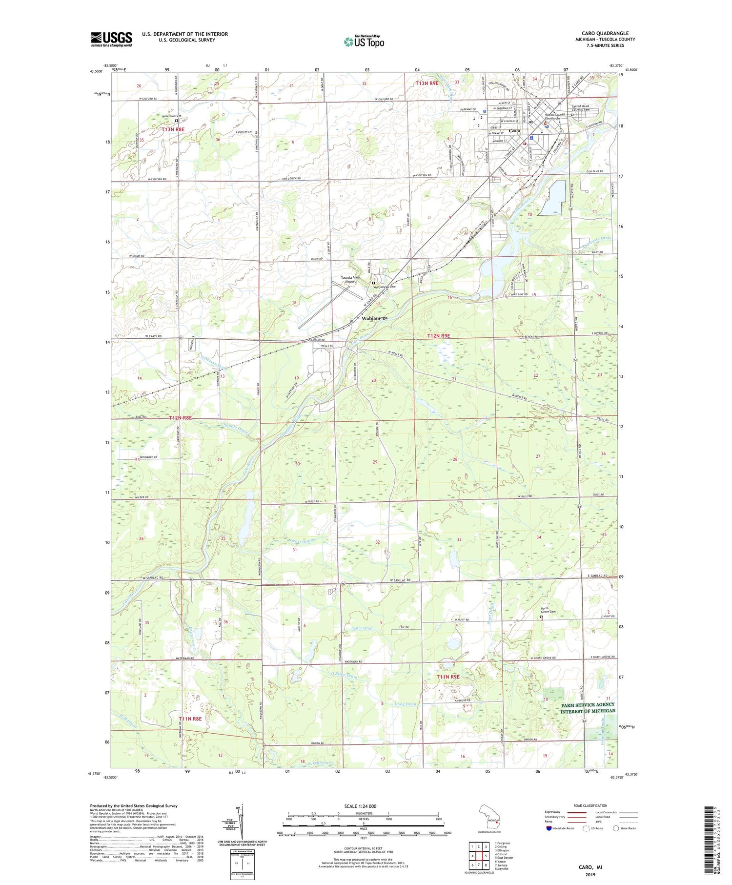
2019 topographic map quadrangle Caro in the state of Michigan. Scale: 1:24000. Based on the newly updated USGS 7.5' US Topo map series, this map is in the following counties: Tuscola. The map contains contour data, water features, and other items you are used to seeing on USGS maps, but also has updated roads and other features. This is the next generation of topographic maps. Printed on high-quality waterproof paper with UV fade-resistant inks.
Quads adjacent to this one:
West: Gilford
Northwest: Fairgrove
North: Colling
Northeast: Ellington
East: East Dayton
Southeast: Mayville
South: Juniata
Southwest: Vassar
Contains the following named places: Arrowhead Country Club, Assembly of God Church, Bader Drain, Barton School, Ben McComb Elementary School, Ber-Wa-Ga-Na Campgrounds, Bethesda Bible Church, Caro, Caro Area District Library, Caro Center, Caro Church of the Nazarene, Caro Family Physicians Clinic, Caro Fire Department, Caro Golf Club, Caro Junior-Senior High School, Caro Masonic Temple Historical Marker, Caro Medical Clinic, Caro Mobile Estates, Caro Mobile Medical Response, Caro Police Department, Caro Post Office, Caro United Methodist Church, Chambers Drain, Chapple Drain, Church of Christ, Church of Jesus Christ of Latter Day Saints, City of Caro, Coleman Drain, Conner School, Craig Drain, Cross Roads Community of Christ Church, Cutts Drain, Evergreen Creek, First Baptist Church, First Presbyterian Church of Caro Historical Marker, Frank E Schall Elementary School, Hutchinson Drain, Indianfields Cemetery, Indianfields Park, Indianfields Township Hall, Indianfields Township Police Department, Kingdom Hall of Jehovah's Witnesses, Lynn Drain, Mclaren Caro Region Hospital, Moreland Cemetery, New Creation Community Church, North Grove Cemetery, North Grove School, Northgrove Post Office, Northwest Drain, O'Brien Drain, Peninsular Sugar Refining Company Historical Marker, Presbyterian Church, Riverview Mobile Home Park, Rooster Flats Golf Center, Sacred Heart Catholic Cemetery, Sacred Heart Catholic Church, Saint Paul Lutheran Church, Schoener Drain, Scott Drain, Sucker Creek, Terry Allen Drain, Township of Indianfields, Trinity Episcopal Church Historical Marker, Tuscola Area Airport, Tuscola County, Tuscola County Advertiser Historical Marker, Tuscola County Courthouse, Tuscola County Courthouse Historical Marker, Tuscola County Fair Historical Marker, Tuscola County Fairgrounds, Tuscola County Sheriff's Office, Tuscola Medical Center, Tuscola State Game Area, Vaughn Village Mobile Home Park, Wahjamega, Wahjamega Cemetery, Wahjamega County Church, Wahjamega Post Office, Wahjamega Station, William H Carson House Historical Marker, WKYO-AM (Caro), ZIP Code: 48723


