MyTopo
Grand Haven Michigan US Topo Map
Couldn't load pickup availability
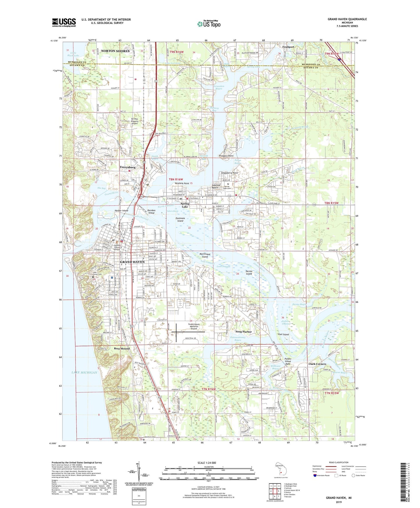
2023 topographic map quadrangle Grand Haven in the state of Michigan. Scale: 1:24000. Based on the newly updated USGS 7.5' US Topo map series, this map is in the following counties: Ottawa, Muskegon. The map contains contour data, water features, and other items you are used to seeing on USGS maps, but also has updated roads and other features. This is the next generation of topographic maps. Printed on high-quality waterproof paper with UV fade-resistant inks.
Quads adjacent to this one:
West: Grand Haven OE W
Northwest: Muskegon West
North: Muskegon East
Northeast: Sullivan
East: Nunica
Southeast: Borculo
South: Port Sheldon
This map covers the same area as the classic USGS quad with code o43086a2.
Contains the following named places: Aloys Bilz House Historical Marker, Beckwith Brook, Bicentennial Memorial Park, Bicentennial Park, Bignell School, Bolt Park, Bruce Bayou, Calvary Christian Fellowship, Central Park, Central School, Central School Historical Marker, Chinook Pier Park, Christ Community Church, Christian Junior High School, Christian School, Christian Science Church, Church of Christ, Church of God, Church of the Healing Christ, Church of the Nazarene, City of Ferrysburg, City of Grand Haven, Clark Corners, Coast Guard Park, Coast Guard Station Grand Haven, Corps of Engineers Boatyard, Country Estates Mobile Home Park, Covenant Life Church, Crockery Chapel, Cutters Boom, De Witt Property Airport, Dermo Bayou, Dermo Island, DeWitt School Historical Marker, Discovery Montessori School, Dornbos Island, Duncan Park, Dunewood Medical Center, Dunlevy Bay, Eastern Park, Eastmans Island, Elliott School, Fellowship Bible Church, Ferry School, Ferrysburg, Ferrysburg Church, Ferrysburg Fire Department, Ferrysburg Nature Preserve, Ferrysburg Post Office, Fire Barn Park, First Baptist Church, First Presbyterian Church, First Reformed Church, Fricke Marine Service, Fruitport District Library, Grand Haven, Grand Haven City Hall, Grand Haven Clinic, Grand Haven Department of Public Safety, Grand Haven Fire Department, Grand Haven High School, Grand Haven Loutit Library, Grand Haven Memorial Airpark, Grand Haven Municipal Marine, Grand Haven Police Department, Grand Haven Post Office, Grand Haven State Game Area, Grand Haven State Park, Grand Haven Station, Grand Haven Township Fire and Rescue, Grand Trunk Depot Historical Marker, Grand Valley Marina, Griffin School, Harbor Island, Hatton Park, Hidden Oaks Mobile Home Park, Highland Park Association Historical Marker, Hofma Park, Holmes School, Indian Channel, Jeffers School, Jerusalem Bayou, Johnston Park, Keenan Marine, Kelly Park, Khardomah Lodge Historical Marker, Kiert Island Park, Kingdom Hall of Jehovah's Witnesses, Klaver Park, Klempel Park, Lake Forest Cemetery, Lake Fran Campground, Lake Hills School, Lake Lorraine, Lakeshore Baptist Academy, Lakeshore Baptist Church, Lakeshore Cemetery, Lakeshore Lutheran Fellowship, Lakeshore Middle School, Lakeside Beach, Little Black Lake, Little Black Lake Park, Lloyd Bayou, Lost Channel, Martinique Island, Mercury Park, Mill Point Park, Millhouse Bayou, Minnie Skwarek Nature Reserve, Mulligans Hollow Park, Norfolk Bay, Norris Creek, North Channel, North Ottawa Community Hospital, North Shore Marina Incorporated, Nortonville Chapel, Nortonville Post Office, Old Kent Pond Park, Ottawa County Building, Ottawa County Youth Home, Peach Plains School, Pettys Bayou, Poel Island, Pomona Park, Potato Island Dyke, Pottamie Post Office, Pottawattomie Bayou, Pottawattomie Park, Prospect Point, Resurrection Life Church, River Bend Marina, River Haven Village Mobile Home Park, Riverside Nursing Center, Robinson Bayou, Robinson Park, Rosy Mound, Rosy Mound School, Saint John's Episcopal Church, Saint John's Lutheran Church, Saint Johns School, Saint Mary's Church, Saint Mary's School, Saint Matthew Church, Saint Patrick's Church, Saint Paul's United Church of Christ, Second Christian Reformed Church, Second Reformed Church, Seventh-Day Adventist Church, Shipwrecks and the Coast Guard Historical Marker, Shore Haven Nursing Home, Sluka Park, Smith Bayou, Snug Harbor, South Channel, Spring Lake, Spring Lake Cemetery, Spring Lake Christian Reformed Church, Spring Lake Country Club, Spring Lake High School, Spring Lake Junior High School, Spring Lake Police Department, Spring Lake Post Office, Spring Lake Presbyterian Church, Spring Lake Township Fire Department Station 1, Spring Lake Township Fire Department Station 2, Spring Lake Township Fire Department Station 3 Central, Spring Lake Wesleyan Church, Spring Lake Yacht Club, Stahl Bayou, State Police in Grand Haven, Stearns Bayou, Stevens Creek, Stone School, Strawberry Point, Sunnyside Park, Susan Hill Yerkes Historical Marker, Tanglewood Park, The Escanaba Historical Marker, The Sag, The Wharf Marina Incorporated, Township of Spring Lake, Tri Cities Historical Museum, Trinity Reformed Church, United Methodist Church, Verplank Point, Village Green Mobile Home Park, Village of Fruitport, Village of Spring Lake, Walden Green Montessori School, Warner Baird District Library, Water Tower Park, Watermark Church, Wayside Chapel, West Michigan Academy of Arts and Sciences, WGHN-AM (Grand Haven), WGHN-FM (Grand Haven), White Plains Middle School, White School, Wolffs Landing, Word of Hope Church, ZIP Codes: 49417, 49456