MyTopo
Holland West Michigan US Topo Map
Couldn't load pickup availability
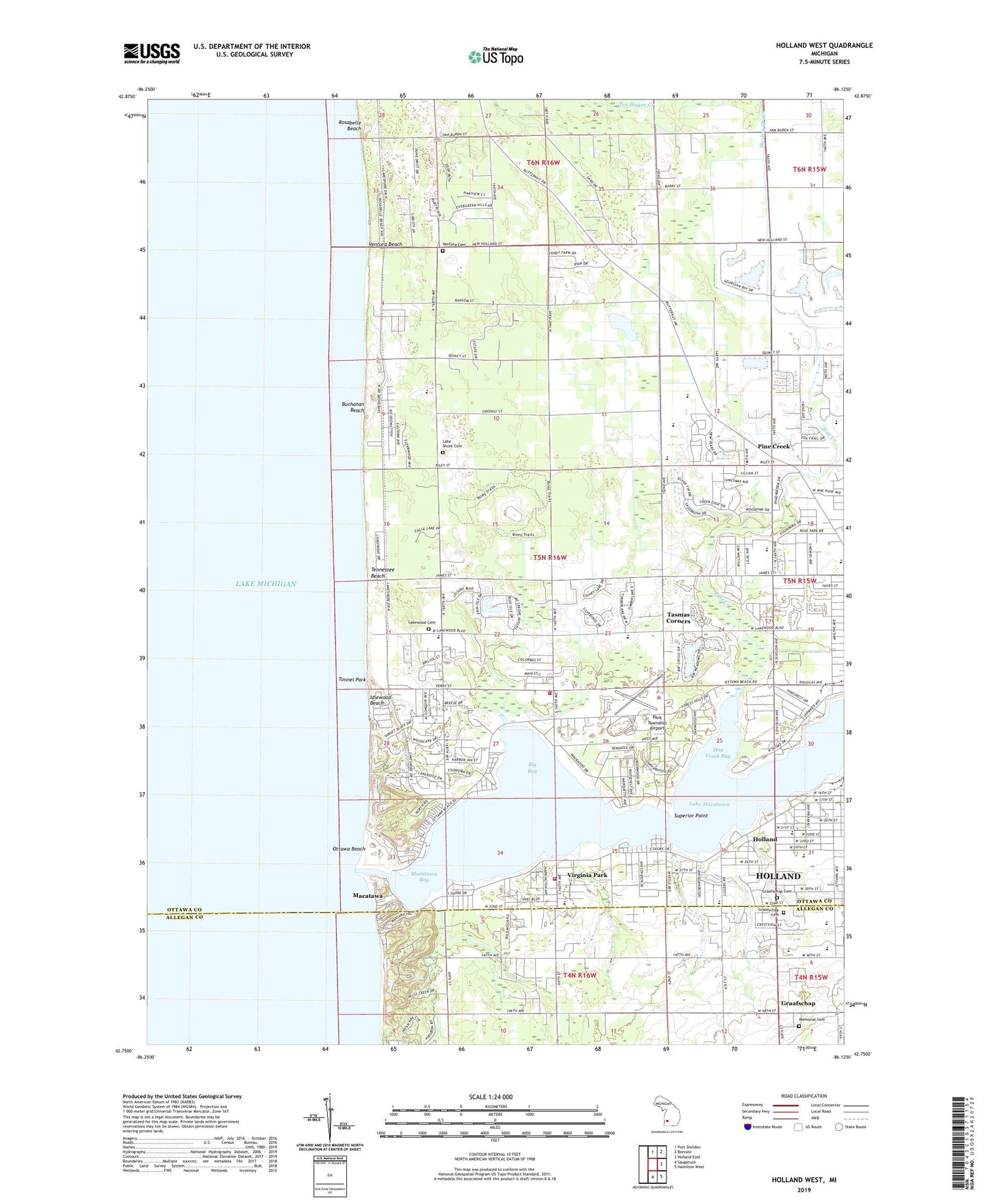
2023 topographic map quadrangle Holland West in the state of Michigan. Scale: 1:24000. Based on the newly updated USGS 7.5' US Topo map series, this map is in the following counties: Ottawa, Allegan. The map contains contour data, water features, and other items you are used to seeing on USGS maps, but also has updated roads and other features. This is the next generation of topographic maps. Printed on high-quality waterproof paper with UV fade-resistant inks.
Quads adjacent to this one:
North: Port Sheldon
Northeast: Borculo
East: Holland East
Southeast: Hamilton West
South: Saugatuck
This map covers the same area as the classic USGS quad with code o42086g2.
Contains the following named places: Anchorage Marina, Bayshore Marina, Bayshore Yacht Club, Beechwood, Beechwood Reformed Church, Big Bay, Buchanan Beach, Calvary Baptist Church, Central Park, Central Park Chapel Historical Marker, Central Park Reformed Church, Central Wesleyan Church, Christ Memorial Reformed Church, Christian Friendship Center, Christian High School, Church of the Nazarene, City of Wyoming Waterworks, Coast Guard Station Holland, Crosswinds Community Church, DeGraaf Nature Center, Fellowship Church, Graafschap, Graafschap Cemetery, Graafschap Christian Reformed Church Historical Marker, Graafschap Post Office, Graafschap Reformed Church, Great Lakes Elementary School, Harbor Lights Middle School, Harderwyk Church, Harlem Drain, Harrington School, Holiday West Village Mobile Home Park, Holland Christian High School, Holland Christian Middle School, Holland Fire Department Station 3, Holland Harbor Historical Marker, Holland Harbor Lighthouse Historical Marker, Holland State Park, Holland West Middle School, Idlewood Beach, Jenison Park, Lake Macatawa, Lake Macatawa Campground, Lake Michigan Campground, Lake Shore Cemetery, Lake Shore Elementary School, Lakeshore Church of Christ, Lakeview Early Childhood Center, Lakeview Park, Lakewood Cemetery, Lakewood School, Macatawa, Macatawa Bay, Macatawa Bay Middle School, Macatawa Bay Yacht Club, Macatawa Legends Golf and Country Club, Macatawa Park, Macatawa Post Office, Marigold Lodge Historical Marker, Memorial Cemetery, Middle Ground Light, Montello Park Christian Church, Montello Park School, North Breakwater Light, Northpoint Assembly of God Church, Oak Grove Resort Campground, Ottawa Beach, Ottawa Beach Historical Marker, Ottawa Beach Post Office, Ottawa County Fairgrounds, Our Lady of the Lake Parish, Park Christian Reformed Church, Park Township Airport, Park Township Fire Department Station 1, Park Township Fire Department Station 2, Parkside Bible Church, Parkside Marina, Peace Lutheran Church, Pine Creek, Pine Creek Bay, Pine Creek Christian Reformed Church, Pine Ridge Christian Elementary School, Quincy Park, Riley Park, Rosabelle Beach, Rose Park Baptist Church, Rose Park Reformed Church, South Pierh Light, South Shore Marina, Superior Point, Tasmas Corners, Tennessee Beach, Township of Park, Tunnel Park, Ventura Beach, Ventura Cemetery, Ventura Church, Ventura Post Office, Virginia Park, Waukazoo School, Waukazoo Woods Historical Marker, Wendt Park, West Ottawa Center School, Westside Christian School, Winstrom Park, Wolters Woods Park, Woodside School, ZIP Codes: 49424, 49434