MyTopo
Lowell Michigan US Topo Map
Couldn't load pickup availability
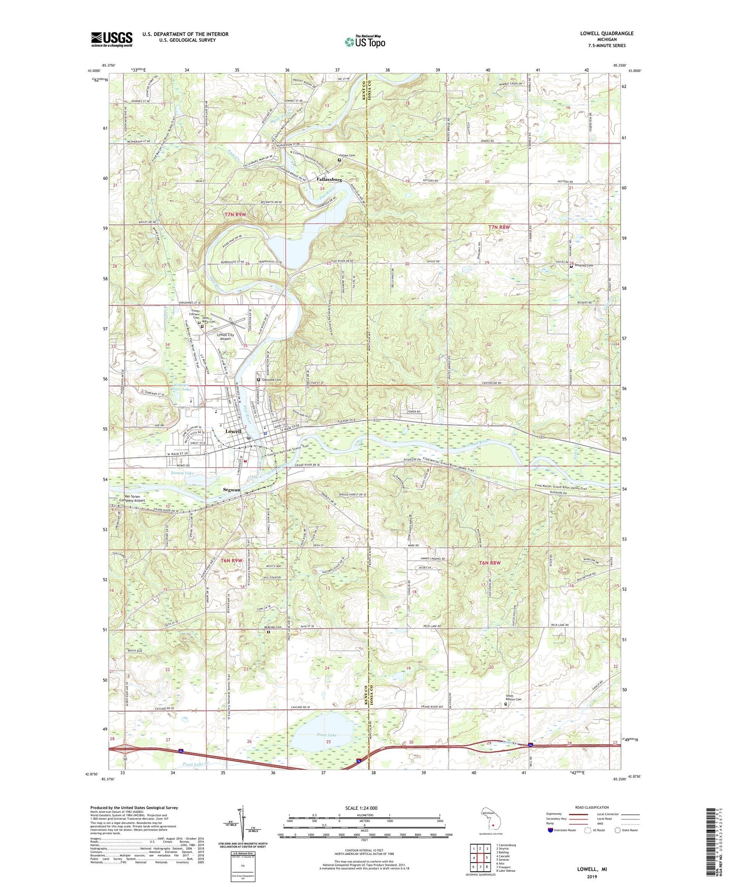
2019 topographic map quadrangle Lowell in the state of Michigan. Scale: 1:24000. Based on the newly updated USGS 7.5' US Topo map series, this map is in the following counties: Ionia, Kent. The map contains contour data, water features, and other items you are used to seeing on USGS maps, but also has updated roads and other features. This is the next generation of topographic maps. Printed on high-quality waterproof paper with UV fade-resistant inks.
Quads adjacent to this one:
West: Cascade
Northwest: Cannonsburg
North: Smyrna
Northeast: Belding
East: Saranac
Southeast: Lake Odessa
South: Freeport
Southwest: Alto
Contains the following named places: Apostolic Lighthouse Church, Avon Post Office, Bushnell Elementary School, Calvary Christian Reformed Church, Carr Drain, Charter Township of Lowell, Cherry Creek Elementary School, Church of the Nazarene, City of Lowell, Congregational Church, Cooper Woodland Preserve, Creekside Park, Dairy Farm Creek, Deer Run Golf Course, Englehardt Library, Fallasburg County Park, Fallasburg Covered Bridge Historical Marker, Fallasburg Pioneer Village Historical Marker, Fallass Cemetery, Fallassburg, Fallassburg Post Office, Flat River, Foxes Corners Cemetery, Free Baptist Church of Lowell, Good Shepherd Lutheran Church, Grand River Riverfront Park, Honey Creek Childrens Home, Impact of Wesleyan Church, John W Fallas Historical Marker, John Wesley Fallas House Historical Marker, Kingdom Hall of Jehovah's Witnesses, Kyser Pit, Lee Creek, Lowell, Lowell Area Fire Department - Look Memorial Fire Station, Lowell Area Historical Museum, Lowell City Airport, Lowell City Hall, Lowell Fairgrounds, Lowell Family Medical Center, Lowell First United Methodist Church, Lowell Middle School, Lowell Police Department, Lowell Post Office, Lowell Senior High School, Lowell State Game Area, Lowell Station, Lyons Baptist Church, McBride Cemetery, McMahen Park, Metro Health Lowell, Natures Place Lake, Oakwood Cemetery, Page Creek, Pinckney Cemetery, Pratt Lake, Pratt Lake Creek, Recreation Park, Richards Park, Robert W Graham Home Historical Marker, Rogers Field, Saint Mary Cemetery, Saint Mary Church, Segwun, South Boston Cemetery, South Boston Church, South Boston Post Office, Stoney Lake, Stoney Lakeside Park and Dog Park, Swan Ponds, Toles Creek, Township of Boston, Township of Keene, Township of Vergennes, Unity School, Upper Bridge Park, Valley Vista Mobile Home Park, ZIP Code: 49331