MyTopo
Ludington Michigan US Topo Map
Couldn't load pickup availability
Also explore the Ludington Forest Service Topo of this same quad for updated USFS data
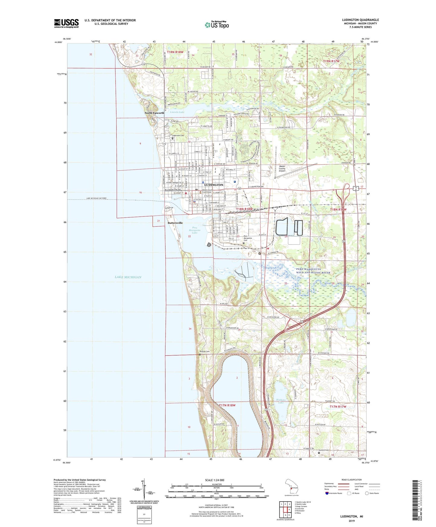
2023 topographic map quadrangle Ludington in the state of Michigan. Scale: 1:24000. Based on the newly updated USGS 7.5' US Topo map series, this map is in the following counties: Mason. The map contains contour data, water features, and other items you are used to seeing on USGS maps, but also has updated roads and other features. This is the next generation of topographic maps. Printed on high-quality waterproof paper with UV fade-resistant inks.
Quads adjacent to this one:
Northwest: Hamlin Lake OE W
North: Hamlin Lake
Northeast: Kings Corners
East: Scottville
Southeast: Wiley
South: Pentwater
This map covers the same area as the classic USGS quad with code o43086h4.
Contains the following named places: A Bygone Lumbering Town Historical Marker, Armistice Day Storm Historical Marker, Bethany Lutheran Church, Burr Creek, Buttersville, Buttersville Park, Buttersville Post Office, Buttersville Station, Calvary Baptist Church, Cartier Campgrounds, Cartier Park, Charter Township of Pere Marquette, City of Ludington, Coast Guard Station Ludington, Community Church, Copeyon Park, Cornerstone Baptist Church, Creator Life Church, Dejonge Junior High School, Dow Chemical Heliport, Emmanuel Lutheran Church, Epworth Assembly, Family Care Clinic, Father Marquette Memorial Cross, Father Marquette Park and Shrine, Foot and Ankle Clinic, Foster School, Franklin School, French School, Grace Episcopal Church, Harbor Light Fellowship Church, Harbor View Marina, Hemlock Golf Club, Heritage Hills Mobile Home Park, Hopkins Lake, James Street Clinic, Kistlers Corner, Kistlers Corners, Lakeside Chapel and Retreat Center, Lakeside Links Golf Course, Lakeside Women's Health Center, Lakeview Cemetery, Lakeview School, Life Emergency Medical Services of Mason County, Lighthouse Baptist Church, Lincoln, Lincoln Hills Golf Course, Lincoln Lake, Lincoln Post Office, Lincoln River, Living Word Church, Longfellow School, Ludington, Ludington Area Catholic School, Ludington Baptist Chapel, Ludington Car Ferries Historical Marker, Ludington City Park, Ludington Fire Department, Ludington High School, Ludington Hydroelectric Plant, Ludington Municipal Marina, Ludington Outboard Club, Ludington Police Department, Ludington Post Office, Ludington Seventh Day Adventist Church, Ludington Station, Ludington Woods Living Center, Ludington Yacht Club, Marquette's Death Historical Marker, Mason County Airport, Mason County Campground, Mason County Courthouse, Mason County Courthouse Historical Marker, Mason County District Library, Mason County Fairgrounds, Mason County Historical Marker, Mason County Sheriff's Office, Memorial Tree Park, Mosquito Creek, North Breakwater Light, North Epworth, North Pierhead Light, Oakview Medical Care Facility, Oriole Field, Peace Lutheran Church, People's Church, Pere Marquette Cemetery, Pere Marquette Charter Township Fire Department, Pere Marquette Lake, Pere Marquette River, Pere Marquette School, Phillips Cemetery, Pleasant View School, Poncho's Pond RV Park, Prayer and Praise Assembly of God Church, Ray Auto Marina, Resurrection Life of Ludington Church, Rose Hawley Museum, Saint Clair Creek, Saint Johns Lutheran Church, Saint Johns School, Saint Simon's Church, Saint Stanislaus School, South Breadwater Light, South Hamlin School, Spectrum Health Ludington Hospital, SS Badger Historical Marker, SS Pere Marquette 18 Historical Marker, Star Port Marina, Stearns Park, Summit Cemetery, Sutton Park, Swanson Creek, Swedish Lutheran Church Historical Marker, Tamarac Sport Fishing Dock, Tendercare of Ludington Nursing Home, Thompson Marina, Trinity Evangelical Free Church, United Methodist Church, United Pentacostal Church, Vacation Station RV Park, Waterfront Park, Wesley Post Office, White Pine Village, WKLA-AM (Ludington), WKLA-FM (Ludington), ZIP Code: 49431