MyTopo
Milford Michigan US Topo Map
Couldn't load pickup availability
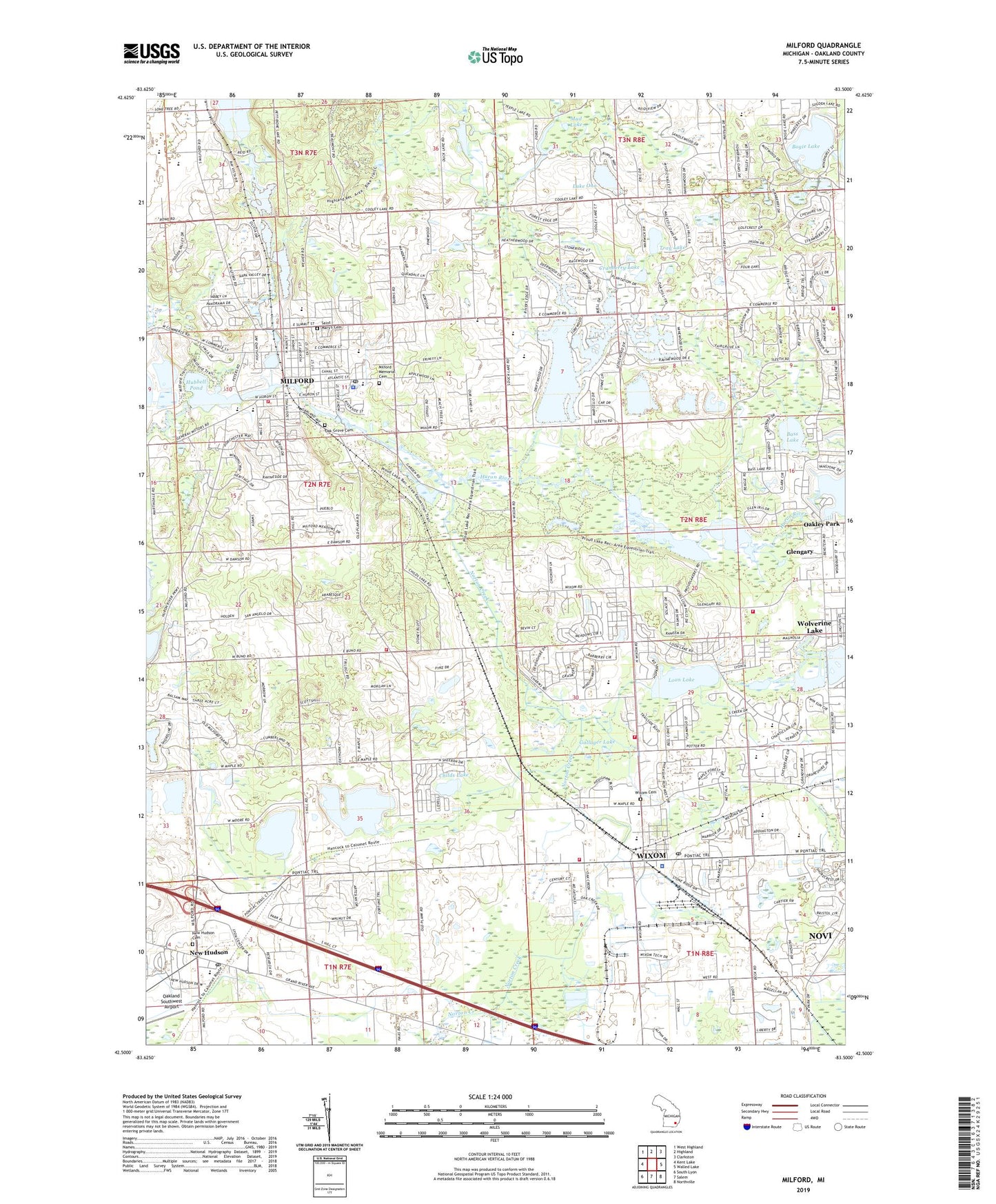
2023 topographic map quadrangle Milford in the state of Michigan. Scale: 1:24000. Based on the newly updated USGS 7.5' US Topo map series, this map is in the following counties: Oakland. The map contains contour data, water features, and other items you are used to seeing on USGS maps, but also has updated roads and other features. This is the next generation of topographic maps. Printed on high-quality waterproof paper with UV fade-resistant inks.
Quads adjacent to this one:
West: Kent Lake
Northwest: West Highland
North: Highland
Northeast: Clarkston
East: Walled Lake
Southeast: Northville
South: Salem
Southwest: South Lyon
This map covers the same area as the classic USGS quad with code o42083e5.
Contains the following named places: Ann L Dolsen Elementary School, Baker Elementary School, Bass Lake, Bogie Lake, Charter Township of Milford, Childs Lake, City of Wixom, Commerce Township Fire Department Station 1, Country Oaks Elementary School, Cranberry Lake, Detroit Finnish Co-operative Summer Camp Historical Marker, Gallager Lake, Glen Lore Golf Club, Glengary, Glengary Elementary School, Hibbard Tavern Historical Marker, Hickory Hill Golf Club, Highland Commons Shopping Center, Hubbell Pond, Hubbell Pond Park, Huron Valley Ambulance Milford, Johnson Elementary School, Kurtz Elementary School, Lake Ona, Lake Sherwood, Loon Lake, Loon Lake Elementary School, Lower Pettibone Lake, Lyon Oaks County Park, Lyon Oaks Golf Course, Milford, Milford Central Park, Milford Fire Department Station 1 Headquarters, Milford Fire Department Station 2, Milford High School, Milford Historical Museum, Milford Memorial Cemetery, Milford Police Dept, Milford Post Office, Moore Lake, Moss Lake, Mud Lake, Muir Middle School, New Hudson, New Hudson Cemetery, New Hudson Post Office, Norton Creek, Oak Grove Cemetery, Oak Grove Cemetery Historical Marker, Oak Valley Middle School, Oakland County Sheriff's Office Commerce Township Substation, Oakland Southwest Airport, Oakland Technical Center Southwest, Pettibone Creek, Prospect Hill Shopping Center, Proud Lake, Proud Lake State Recreation Area, Providence Medical Center - Milford, Saint Mary's Cemetery, Saint Marys Church, Sarah G Banks Middle School, Sherwood Creek, Spencer Field, T and M Companies Heliport, Tray Lake, Twin Sun Lakes, Village of Milford, Walled Lake Middle School, Walled Lake Western High School, Wixom, Wixom Cemetery, Wixom Cemetery Historical Marker, Wixom Charms Plaza Shopping Center, Wixom Christian School, Wixom Elementary School, Wixom Fire Department Station 1 Headquarters, Wixom Fire Department Station 2, Wixom Plaza Shopping Center, Wixom Police Department, Wixom Post Office, Wixom-Wire House Historical Marker, ZIP Codes: 48165, 48381, 48382, 48393