MyTopo
Montague Michigan US Topo Map
Couldn't load pickup availability
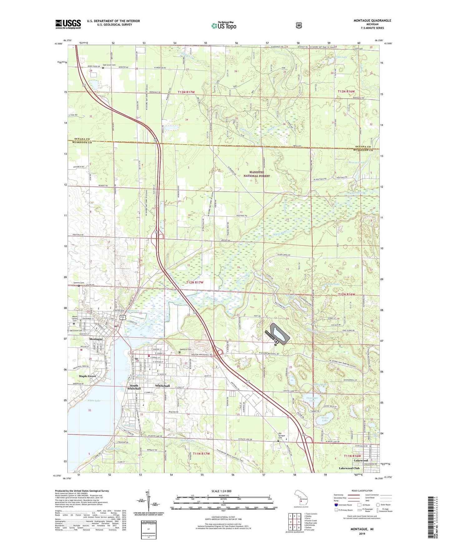
2019 topographic map quadrangle Montague in the state of Michigan. Scale: 1:24000. Based on the newly updated USGS 7.5' US Topo map series, this map is in the following counties: Muskegon, Oceana. The map contains contour data, water features, and other items you are used to seeing on USGS maps, but also has updated roads and other features. This is the next generation of topographic maps. Printed on high-quality waterproof paper with UV fade-resistant inks.
Quads adjacent to this one:
West: Flower Creek
Northwest: Town Corners
North: Shelby
Northeast: Ferry
East: Big Blue Lake
Southeast: Twin Lake
South: Dalton
Southwest: Michillinda
Contains the following named places: Austin Lake, Browns Pond, Bush Creek, Carleton Creek, Carlton Creek, Chisholm School, City of Montague, City of Whitehall, Covell Park, Crystal Downs Mobile Village, Cullen Field, Dalton Lake, Durham Road Playground, Ealy Elementary School, Ellenwood Park, Evangelical Covenant Church, Faith Lutheran Church, Ferry Memorial Reformed Church, Fogg Lake, Funnel Field, Gee Park, Goodrich Park, Grass Lake, Heartland Health Care Center, Hickory Knoll Golf Course, Hilt's Landing, Hiscuit Lake, Lebanon Lutheran Church, Lebanon Lutheran Church Historical Marker, Lions Park, Lumbering on White Lake Historical Marker, Maple Grove, Maple Grove Park, Mill Pond, Mill Pond Creek, Mill Pond Park, Montague, Montague City Hall, Montague City Museum, Montague City Public Library, Montague Fire District Authority, Montague High School, Montague Marina, Montague Police Department, Montague Post Office, Montague Station, Montague United Methodist Church, Mount Calvary Cemetery, Mud Creek, New Beginnings Assembly of God Church, Norman Park, Oak Grove Cemetery, Oakhurst Cemetery, Oehrli School, Old Sprague Cemetery, Ottiger Airport, Owasippe Lake, Rothbury Rest Area, Ruth Thompson Historical Marker, Saint James Catholic Church, Saint James Catholic School, Saint James Lutheran Church, Sammis Cemetery, Sand Creek, Schneider Lake, Shoreline Elementary School, Silver Creek, Silver Creek Pond, Slocum Park, South Whitehall, Staples and Covell Mill Historical Marker, Svensson Park, Sweets Station, Sweet's Station Post Office, Thomas Creek, Township of Montague, Township of Whitehall, Trailway Campground, Village of Lakewood Club, Wayside Mobile Court, White Lake Ambulance Authority, White Lake Congregational Church, White Lake Fire Authority, White Lake Golf Club, White Lake Wesleyan Church, White Lake Yacht Club Historical Marker, White River, White River Campground, Whitehall, Whitehall City Hall, Whitehall Community Library, Whitehall High School, Whitehall Middle School, Whitehall Police Department, Whitehall Post Office, Whitehall Township Hall, Whitehall United Methodist Church, Whitelake Church, Wildcat Creek, WPBK-AM (Whitehall), ZIP Code: 49461