MyTopo
Niles West Michigan US Topo Map
Couldn't load pickup availability
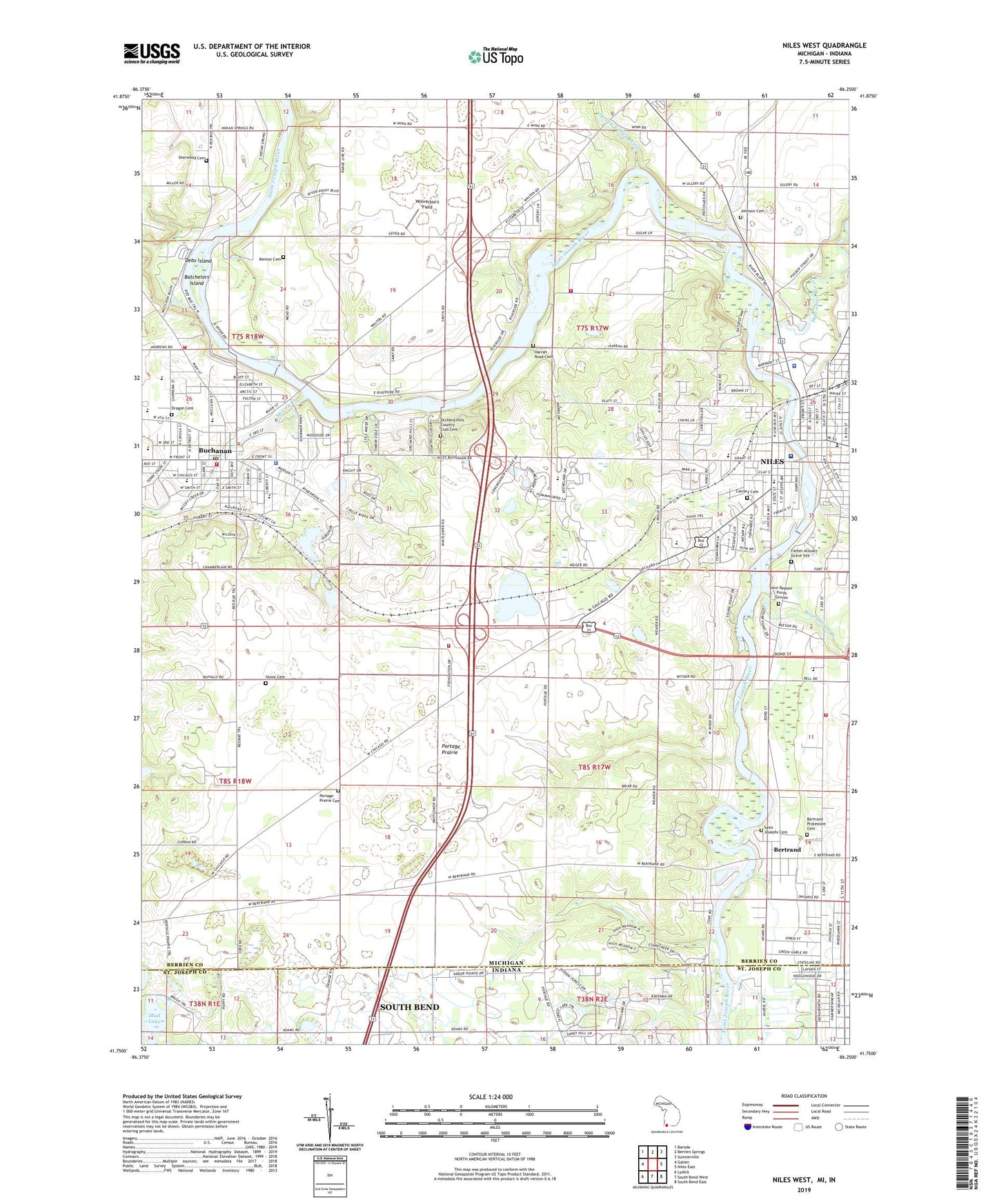
2019 topographic map quadrangle Niles West in the states of Michigan, Indiana. Scale: 1:24000. Based on the newly updated USGS 7.5' US Topo map series, this map is in the following counties: Berrien, St. Joseph. The map contains contour data, water features, and other items you are used to seeing on USGS maps, but also has updated roads and other features. This is the next generation of topographic maps. Printed on high-quality waterproof paper with UV fade-resistant inks.
Quads adjacent to this one:
West: Galien
Northwest: Baroda
North: Berrien Springs
Northeast: Sumnerville
East: Niles East
Southeast: South Bend East
South: South Bend West
Southwest: Lydick
Contains the following named places: Allouez Park, Ballard Junior High School, Batchelors Island, Beeson Mausoleum, Benton Cemetery, Berrien County Sheriff's Office Niles Substation, Bertrand, Bertrand Bible Church, Bertrand Historical Marker, Bertrand Post Office, Bertrand Protestant Cemetery, Bertrand Township Fire Department Station 2, Bethel Apostolic Tabernacle Church, Brandywine Creek, Brookwood Golf Course, Buchanan, Buchanan Cemetery, Buchanan Church of Christ, Buchanan City Hall, Buchanan Dam, Buchanan District Library, Buchanan Family Medical Center, Buchanan Fire Department, Buchanan High School, Buchanan Middle School, Buchanan Police Department, Buchanan Post Office, Buchanan Township Fire Department, Calvary Cemetery, Carnegie Library, Cedar Lane School, Central School, Church of God Full Gospel, Church of Jesus Christ of Latter-Day Saints, City of Buchanan, Clevenger Park, Community Evangelical Free Church, Country Acres Mobile Home Park, Crescent Lake, Debs Island, Dowagiac River, Dragoo Cemetery, Dreamwold Heights, Dutch Corners, E B Clark Park, Eagle Street Park, Emmanuel Baptist Bible Church, Fairland Christian Church, Faith United Methodist Church, Father Allouez Grave Site, Fernwood Botanical Gardens and Nature Preserve, Ferry Street Historical Marker, Firehouse Park, First Presbyterian Church, First United Methodist Church, FOP Park, Fort Saint Joseph Historical Marker, Fort Saint Joseph Museum, Fort Saint Joseph Park, Four Flags Hotel Historical Marker, Free Methodist Church, French Field, Grace United Methodist Church, Harrah Road Cemetery, Henry Austin Chapin Historical Marker, Howe Cemetery, Howe School, Island Park, Jehovah's Witnesses, John and Horace Dodge Historical Marker, Johnson Cemetery, Johnson Cemetery Historical Marker, Kathryn Park, Kiell Pit, Lake Michigan College-Bertrand Crossing Campus, Lakeland Community Hospital Niles, Lakeland Women's Health Center, Lively Stone Community Church, Madeline Bertrand County Park, McCoy Creek, McCoy Creek Recreation Area, McCoy Pond Park, Memorial Field, Moccasin Bluff Historical Marker, Moccasin School, Morris Volunteer Fire Department, Mount Calvary Baptist Church, Mount Zion Church of God, Mud Lake, Nelson Airport, New Bell School, New Good Hope Baptist Church, Niles, Niles Charter Township Fire Department South Station, Niles City Hall, Niles Community Library, Niles Railroad Depot, Niles Station, Nub Lake Campground, Orchard Hill Country Club, Orchard Hills Country Club Cemetery, Ottowa Elementary School, Parc Aux Vaches-Madeline Bertrand Park Historical Marker, Plym Park, Plym Park Golf Course, Portage Prairie, Portage Prairie Cemetery, Portage Prairie Church, Portage Prairie United Methodist Church, Portage Road General Baptist Church, Ravish Park, Redbud Riverfront Park, Redbud Trail Church Camp, Ring Lardner Historical Marker, Riverfront Park, Riverside Church Camp, Riverside Mobile Home Estates, Saint Anthony Catholic Church, Saint John's United Church of Christ, Saint Josephs Cemetery, Saint Joseph's Mission Historical Marker, Saint Mary's Catholic Church, Saint Mary's Historical Marker, Saint Marys School, Saint Matthews Baptist Church, Saint Paul's Lutheran Church, Samson Park, Second Baptist Church Historical Marker, Seventh Day Adventist School, Seventh-Day Adventist Church, Sherwood Cemetery, Signal Point Country Club, Silverbrook Manor, Smith Park, Southwestern Michigan Community Ambulance Services, Spring Valley Drain, Stafford Woods Park, Stark School, State Line, The Chapin House Historical Marker, The Dodge Brothers Historical Marker, Tot Lot, Township of Bertrand, Township of Niles, Trinity Church Historical Marker, Trinity Episcopal Church, WAOR-FM (Niles), Wesley United Methodist Church, Wesley United Methodist Church Historical Marker, Westside School, Westside Seventh Day Adventist Church, WNIL-AM (Niles), Wolverton's Field