MyTopo
Niles East Michigan US Topo Map
Couldn't load pickup availability
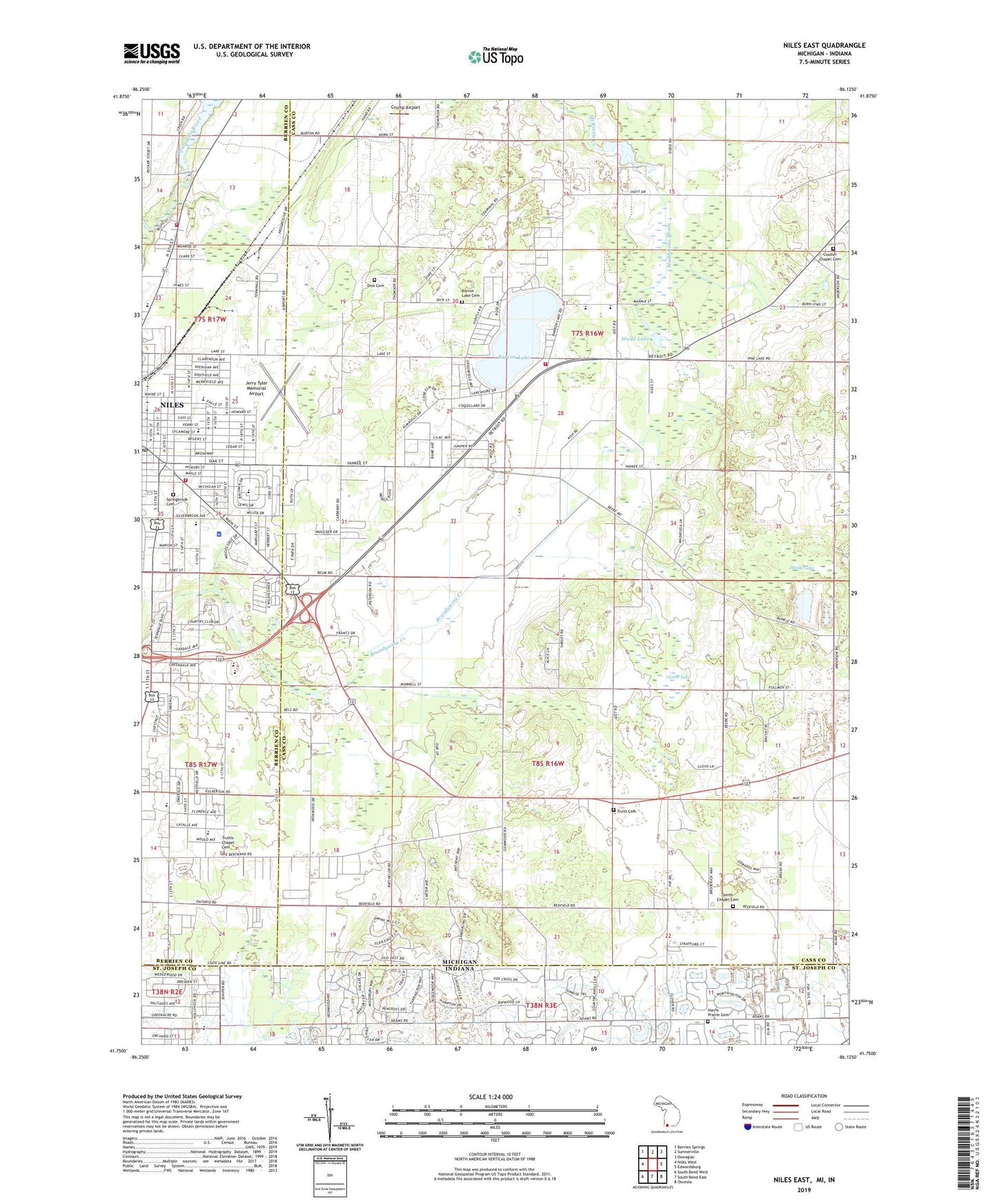
2023 topographic map quadrangle Niles East in the states of Michigan, Indiana. Scale: 1:24000. Based on the newly updated USGS 7.5' US Topo map series, this map is in the following counties: Cass, Berrien, St. Joseph. The map contains contour data, water features, and other items you are used to seeing on USGS maps, but also has updated roads and other features. This is the next generation of topographic maps. Printed on high-quality waterproof paper with UV fade-resistant inks.
Quads adjacent to this one:
West: Niles West
Northwest: Berrien Springs
North: Sumnerville
Northeast: Dowagiac
East: Edwardsburg
Southeast: Osceola
South: South Bend East
Southwest: South Bend West
This map covers the same area as the classic USGS quad with code o41086g2.
Contains the following named places: Apostolic Christian Tabernacle Church, Barron Lake, Barron Lake Cemetery, Barron Lake Post Office, Barron Lake Station, Beacon Baptist Church, Bernhandt School, Bethel Baptist Church, Bethel Tabernacle, Bethlehem Baptist Church, Birch Crest Estates, Birkholm Park, Brandywine High School, Brandywine Junior High School, Brick School, Christ Center Church, Church of Christ, Church of Jesus Christ, City of Niles, Coulter Chapel, Coulter Chapel Cemetery, Coulter School, Crump Airport, Dibble Lake, Dick Cemetery, Eastside Park, Eastside School, Edward Eggleston Elementary School, Electric Light School, Ellis School, First Assembly of God Church, First Baptist Church, First Church of Christ, First Church of God, First Missionary Church, Franklin Woods Mobile Home Park, Fulkerson Park, Fulkerson Park Baptist Church, Goose Lake, Harris Prairie Cemetery, Holy Trinity Lutheran Church, Hope Community Church, Howard Branch Library, Howard School, Howard Township Police Department, Howard Township Volunteer Fire Department, Huntly Memorial Baptist Church, Jehovah's Witnesses, Jerry Tyler Memorial Airport, Merritt School, Michiana Christian Embassy, Michigan State Police District 5 Niles Post 53, Mount Olive Baptist Church, Mudd Lake, Mudd Lake Drain, Mudd Lake Extension Drain, New Harvest Church of God, Niles Charter Township Fire Department North Station, Niles Fire Department, Niles Grace Brethren Church, Niles Pines Mobile Estates, Niles Police Department, Niles Post Office, Niles Senior High School, Niles Township Police Department, North Niles, Northside School, Oak Manor School, Ontario Place Mobile Home Park, Pepper Martin Park, Philadelphia Seventh Day Church, Rentz Ultralight Airport, Ring Lardner Junior High School, Rosewarne School, Saathoff Park, Saint Mark Catholic Church, Saint Marks School, Saint Paul's Lutheran Church, Silverbrook Cemetery, Smith Chapel, Smith's Chapel Cemetery, Smith's Chapel Historical Marker, South Side School, Southside Park, Southside School, Southwestern Medical Clinic, Spaulding Lake Campground, Spiritual Vision Church, Thompson School, Tot Park, Township of Howard, Township of Milton, Trinity United Methodist Church, Troost Park, Truitt Cemetery, Truitts Chapel Cemetery, Truitts Post Office, Truitts Station, Van Ness School, Westminster Presbyterian Church, Winkler School, Yankee Street School, ZIP Code: 49120