MyTopo
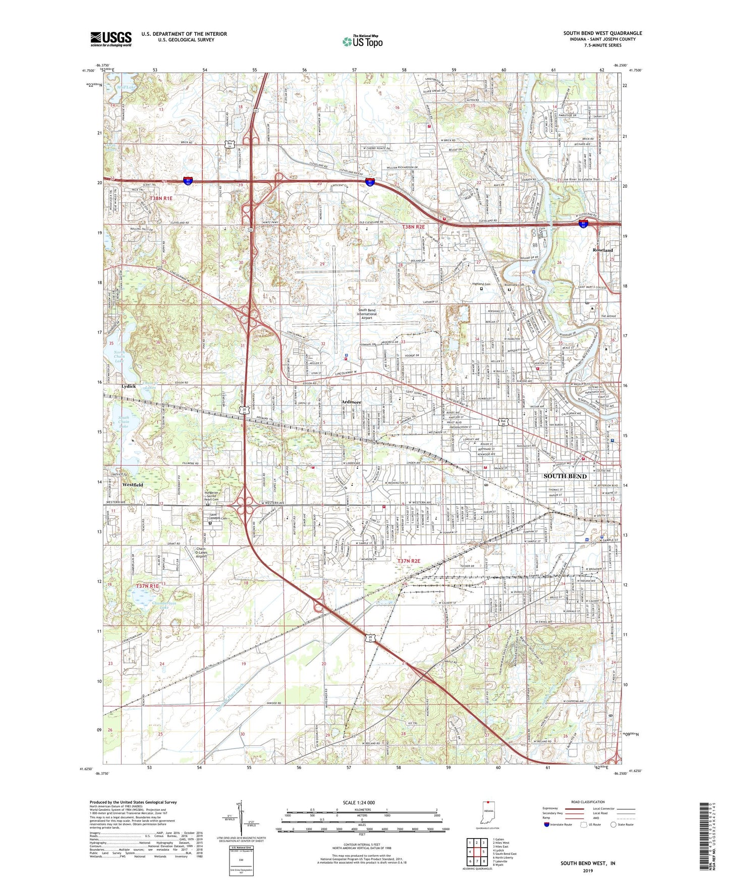
South Bend West Indiana US Topo Map
Couldn't load pickup availability
2022 topographic map quadrangle South Bend West in the state of Indiana. Scale: 1:24000. Based on the newly updated USGS 7.5' US Topo map series, this map is in the following counties: St. Joseph. The map contains contour data, water features, and other items you are used to seeing on USGS maps, but also has updated roads and other features. This is the next generation of topographic maps. Printed on high-quality waterproof paper with UV fade-resistant inks.
Quads adjacent to this one:
West: Lydick
Northwest: Galien
North: Niles West
Northeast: Niles East
East: South Bend East
Southeast: Wyatt
South: Lakeville
Southwest: North Liberty
This map covers the same area as the classic USGS quad with code o41086f3.
Contains the following named places: Alexis Coquillard Elementary School, Ardmore, Belleville Gardens Playground, Bendix Park, Brown School, Central High School, Chain O' Lakes, Chain-O-Lakes Airport, Chamberlain Lake, Chippewa Post Office, City of South Bend, Clay Fire Territory Station 23, Colfax School, Corpus Christi School, First Presbyterian Church, First United Methodist Church, German Township Volunteer Fire Department Station 2, Hansel Neighborhood Center, Harrison Park, Harrison Primary Center School, Healthwin Hospital, Highland Cemetery, Holy Cross College, Holy Cross Elementary School, Holy Family School, Hungarian Sacred Heart Cemetery, Immanuel Church, Indiana Emergency Service, Indiana Vocational Technical School, James Madison Elementary School, Judy Creek, Kaiser Park, Kaley School, Keller Park, La Salle Park, Lafayette Elementary School, Lake Chapel, Lasalle High School, Leeper Park, Linden School, Marquette Elementary School, McClures Airport, Memorial Hospital of South Bend, Monson Chapel, Morris Performing Arts Center, Mount Pleasant Church, Muessel Grove Park, Muessel Primary Center, Navarre Park, North Chain Lake, Olive Street Post Office, Oliver School, Our Lady of Hungary Catholic School, Pierre Navarre Middle School, Pinhook Lake, Pinhook Park, Portage Chapel, Portage Township Volunteer Fire Department, Riverview Cemetery, Roseland, Rum Village Park, Sacred Heart School, Saint Adalbert School, Saint Casimirs School, Saint John the Baptist Elementary School, Saint Joseph County Airport Authority Department of Public Safety Fire Station, Saint Joseph County Sheriff's Office, Saint Joseph High School, Saint Josephs Cemetery, Saint Mary of the Assumption School, Saint Mary's College, Saint Marys College Post Office, Saint Patrick School, Saint Pauls School, Saint Stanislawa School, Saint Stephens School, South Bend, South Bend City Waterworks, South Bend Civic Theatre, South Bend Country Club, South Bend Fire Department Station 11, South Bend Fire Department Station 2, South Bend Fire Department Station 4, South Bend Fire Department Station 5, South Bend Fire Department Station 6, South Bend Fire Department Station 7, South Bend International Airport, South Bend Motor Speedway, South Bend Plaza, South Bend Police Department, South Bend Sand and Gravel Pit, South Bend Wastewater Treatment Plant, South Chain Lake, Tower Building, Town of Roseland, Township of German, Township of Portage, Varga's Nursery, Voorde Park, Walker Field, Washington High School, Westhaven Park, Woodrow Wilson School, ZIP Codes: 46556, 46601, 46613, 46616, 46619, 46628