
MyTopo
Excelsior Springs Missouri US Topo Map
Couldn't load pickup availability
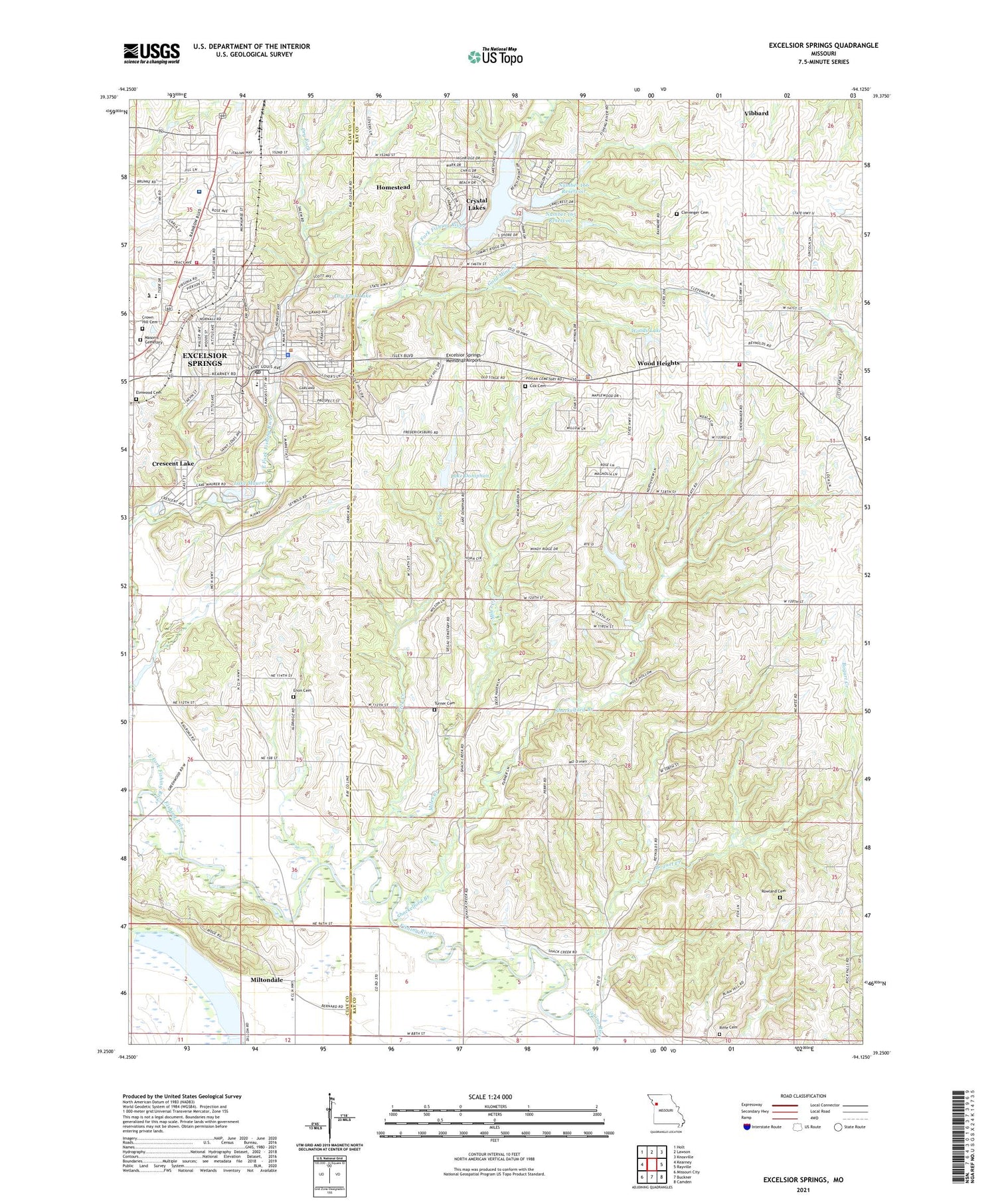
2021 topographic map quadrangle Excelsior Springs in the state of Missouri. Scale: 1:24000. Based on the newly updated USGS 7.5' US Topo map series, this map is in the following counties: Ray, Clay. The map contains contour data, water features, and other items you are used to seeing on USGS maps, but also has updated roads and other features. This is the next generation of topographic maps. Printed on high-quality waterproof paper with UV fade-resistant inks.
Quads adjacent to this one:
West: Kearney
Northwest: Holt
North: Lawson
Northeast: Knoxville
East: Rayville
Southeast: Camden
South: Buckner
Southwest: Missouri City
Contains the following named places: Bogart Creek, Chick, City of Crystal Lakes, City of Excelsior Springs, City of Wood Heights, Clevenger Cemetery, Clevenger School, Coopers, Cox Cemetery, Crescent Lake, Crescent Lake Christian Academy, Crown Hill Cemetery, Crystal Lakes, Crystal Lakes Section 31 Dam, Dry Fork, Dry Fork Lake, East Fork Fishing River, Elmwood Cemetery, Enon Cemetery, Excelsior Institute, Excelsior Springs, Excelsior Springs Career Center, Excelsior Springs Fire Department, Excelsior Springs High School, Excelsior Springs Hospital, Excelsior Springs Memorial Airport, Excelsior Springs Police Department, Excelsior Springs Post Office, Excelsior Springs Technology High School, Excelsior Springs Waterworks, Gold Mine Creek, Golf Hill, Greenwood School, Hall School, Harris, Hedges Lake Dam, Homestead, Isley School, Keeney Creek, KEXS-AM (Excelsior Springs), KLTY-FM (Liberty), Lake Arrowhead Dam, Lake Doniphan, Lake Doniphan Dam-Lower Dam, Lake Maurer, Lewis Elementary School, Lick Creek, Maurer Lake Dam, Miles Creek, Miltondale, Moore School, New Garden, New Garden Church, New Garden School, Number 165 Dam, Number 165 Reservoir, Number 166 Reservoir, Number 172 Reservoir, Odell Church, Old New Garden Church, Pisgah Church, Red Brush School, Riffe Cemetery, Rowland Cemetery, Saint Stephens Lake Dam, Shackelford Branch, Siloam Park, Sunnyside Park, Sunnyside School, Three Springs Farm Lake Dam, Timber Lake Dam, Township of Fishing River, Turner Cemetery, Union School, Upper Doniphan Dam, Village of Homestead, Wallace School, Westview Elementary School, Wood Heights, Wood Heights Fire Protection District, Wood Heights Police Department, Woods Lake, Wyman School, ZIP Code: 64024


