MyTopo
Joplin West Missouri US Topo Map
Couldn't load pickup availability
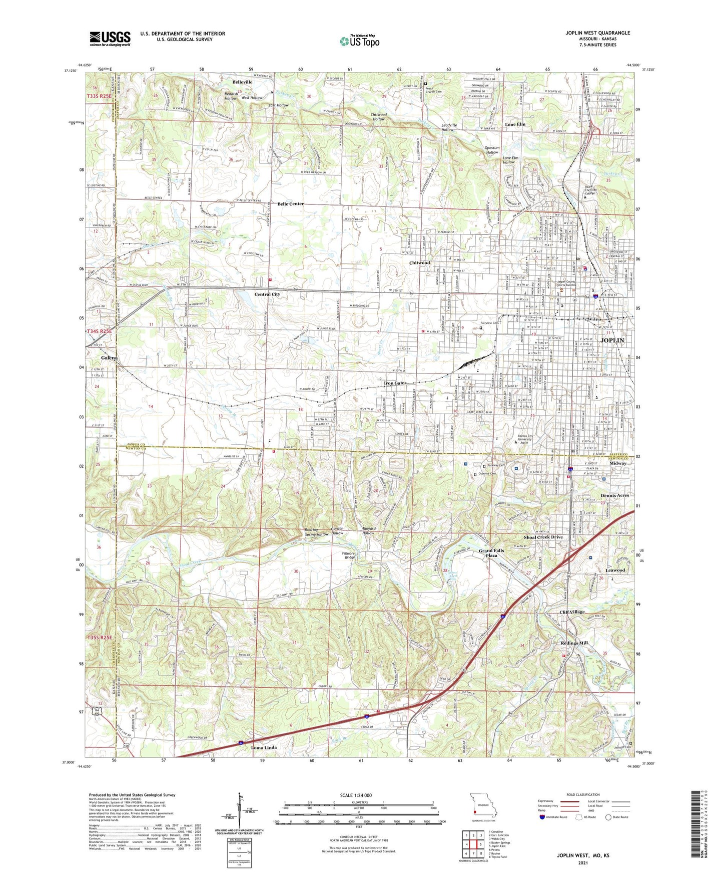
2021 topographic map quadrangle Joplin West in the states of Missouri, Kansas. Scale: 1:24000. Based on the newly updated USGS 7.5' US Topo map series, this map is in the following counties: Jasper, Newton, Cherokee. The map contains contour data, water features, and other items you are used to seeing on USGS maps, but also has updated roads and other features. This is the next generation of topographic maps. Printed on high-quality waterproof paper with UV fade-resistant inks.
Quads adjacent to this one:
West: Baxter Springs
Northwest: Crestline
North: Carl Junction
Northeast: Webb City
East: Joplin East
Southeast: Tipton Ford
South: Racine
Southwest: Peoria
Contains the following named places: Alcott School, Beef Branch, Beef Branch Church, Belle Center, Belleville, Blendville, Carl Junction Fire Protection District Station 2, Carl Junction Satellite School, Cecil Floyd Elementary School, Central City, Central City School, Chitwood, Chitwood Hollow, City of Joplin, Cliff Village, Columbia Elementary School, Cottonwood Springs, Cunningham Park, Dennis Acres, East Hollow, Emerson Elementary School, Fairview Cemetery, Fairview School, Fillmore Bridge, Franklin School, Franklin Technology Center, Freeman Hospital East, Freeman Hospital West, Galena Assembly of God Church, Garvin Park, Gordon Hollow, Grand Falls, Grand Falls Dam, Grand Falls Plaza, Greenwood Church, Greenwood School, Gregg, Gregg School, Iron Gates, Irving Elementary School, Jackson, Jacobs Branch, Jefferson Elementary School, Joplin, Joplin Creek, Joplin Fire Department Station 1, Joplin Fire Department Station 2, Joplin Fire Department Station 4, Joplin High School, Joplin Police Department, Joplin Post Office, Joplin Station A Post Office, Joplin Water Supply Lake, Jungo Stadium, Kelsey Norman Elementary School, KFSB-AM (Joplin), KKUZ-FM (Joplin), KOBC-FM (Joplin), KODE-TV (Joplin), KOZJ-TV (Joplin), KQYX-AM (Joplin), KSNF-TV (Joplin), KSSC-AM (Joplin), KSYN-FM (Joplin), LaFayette School, Landmark Hospital of Joplin, Landreth Park, Leadville Hollow, Lone Elm, Lone Elm Church, Lone Elm Hollow, Longfellow School, Maiden Lane Shops, McAuley High School, McClelland Park, McClelland School, Memorial Middle School, Mercy Hospital Joplin, Midway, Missouri Department of Conservation Forestry Southwest Regional Field Fire Office Joplin, North Middle School, Opossum Hollow, Osborne Cemetery, Ozark Bible College, Parkway Cemetery, Peace Church Cemetery, Rainey Lake Dam, Reddish Hollow, Redings Mill, Redings Mill Fire Protection District Station 1 Headquarters, Redings Mill Fire Protection District Station 5, Redings Mill School, Roaring Spring Hollow, Saint John's Regional Medical Center, Saint Marys Elementary School, Saint Peters Middle School, Schifferdecker Park, Shoal Creek Drive, Shoal Creek Falls, Silver Creek, South Middle School, Spiva Park, Spring Branch, Spring Creek, Stapleton Elementary School, Tanyard Hollow, Town of Grand Falls Plaza, Township of Galena, Township of Shoal Creek, Twin Hills Country Club, Village of Cliff Village, Village of Dennis Acres, Village of Leawood, Village of Redings Mill, Village of Shoal Creek Drive, Washington Education Center, West Central Elementary School, West Hollow, West Joplin, WMBH-AM (Joplin), Woodvine School, ZIP Code: 64804