MyTopo
Springfield Missouri US Topo Map
Couldn't load pickup availability
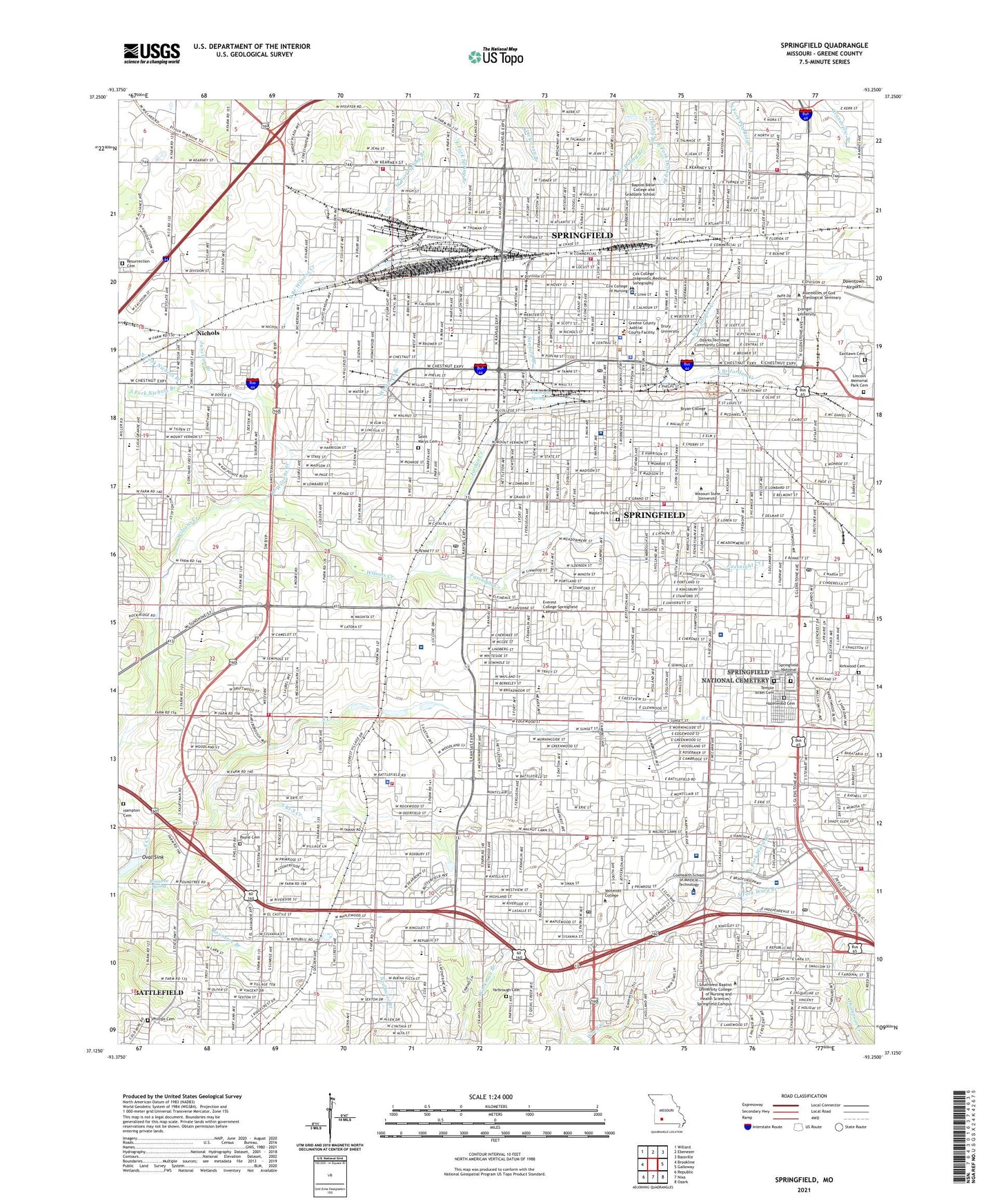
2021 topographic map quadrangle Springfield in the state of Missouri. Scale: 1:24000. Based on the newly updated USGS 7.5' US Topo map series, this map is in the following counties: Greene. The map contains contour data, water features, and other items you are used to seeing on USGS maps, but also has updated roads and other features. This is the next generation of topographic maps. Printed on high-quality waterproof paper with UV fade-resistant inks.
Quads adjacent to this one:
West: Brookline
Northwest: Willard
North: Ebenezer
Northeast: Bassville
East: Galloway
Southeast: Ozark
South: Nixa
Southwest: Republic
Contains the following named places: Bailey School, Battlefield, Battlefield Fire Protection District Station 3, Battlefield Mall Shopping Center, Battlefield Plaza, Bell Victory School, Berry School, Bethany Church, Bingham School, Bisset School, Bissett School, Bluff School, Bowerman School, Boyd School, Campbell School, Carr Park, Central High School, Chadwick Junction, City of Springfield, Cowden School, Cox Medical Centers Meyer Orthopedic and Rehabilitation Hospital, Cox Medical Centers North Hospital, Cox Medical Centers South Hospital, Crenshaw School, Delaware School, Disney School, Doctors Hospital of Springfield, Doling Park, Doling School, Drury University, Durst Park, East Fork Doling Branch, East Fork Spring Branch, Eastlawn Cemetery, Eastwood Junior High School, Eugene Field School, Evangel University of the Assemblies of God, Fairbanks School, Fassnight Creek, Fassnight Park, Fremont Center, Fremont School, Fulbright Spring, Glenstone Post Office, Grant Beach Park, Grant Park, Greene County Alms House, Greene County Sheriff's Office, Haseltine Branch, Hazelwood Cemetery, Holland School, Horace Mann Elementary School, Hulston Cancer Center, Immaculate Conception School, Jarrett Middle School, Jordan Creek, Junction Branch, KGBX-AM (Springfield), KICK-AM (Springfield), Kickapoo High School, Kickapoo School, Kirkwood Cemetery, Kirkwood Park, KLFJ-AM (Springfield), KSMU-FM (Springfield), KTOZ-AM (Springfield), Ktts Heliport, KWFC-FM (Springfield), KWTO-AM (Springfield), KXUS-FM (Springfield), Ky-3 Heliport, Lafayette Park, Lakeland Behavioral Health System, Lakeview School, Lester E Cox Medical Center North Heliport, Lester E Cox Medical Center South Heliport, Lincoln Memorial Park Cemetery, Maple Park Cemetery, Mark Twain School, McDaniel School, McGregor School, Meador Park, Mercy Hospital Springfield, Missouri State University, Nichols, Nichols Branch, Nichols Park, North Branch Jordan Creek, North Branch Wilsons Creek, North Fork Nichols Branch, North Fork Ward Branch, North Town Mall, Oval Sink, Park Central Square, Parkcrest Village Shopping Center, Parkview High School, Payne Cemetery, Pepperdine School, Phelps Gifted Center, Phelps Grove Park, Phillips Cemetery, Pipkin Junior High School, Pleasant Springs Church, Portland School, Reed Junior High School, Robberson School, Roundtree School, Rountree School, Rountree Spring, Saint Agnes High School, Saint Agnes School, Saint De Chantel Academy, Saint Johns Regional Health Center Heliport, Saint Joseph School, Saint Marys Cemetery, Sanford Branch, Select Specialty Hospital - Springfield, Sherwood School, Smith Golf Course, Smith Park, South Branch Jordan Creek, South Branch South Creek, South Creek, South Fork Nichols Branch, South Fork Ward Branch, South Junction, Southern Hills Shopping Center, Southgate Shopping Center, SPFD James River Postal Store Post Office, Springfield, Springfield Community Hospital Heliport, Springfield Fire Department Station 1, Springfield Fire Department Station 10, Springfield Fire Department Station 2, Springfield Fire Department Station 4, Springfield Fire Department Station 5, Springfield Fire Department Station 6, Springfield Fire Department Station 7, Springfield Fire Department Station 8, Springfield Fire Department Station 9, Springfield National Cemetery, Springfield Police Department, Springfield Post Office, Study School, Sunshine School, Teft School, Temple Israel Cemetery, Tom Watkins Park, Town and Country Plaza, Township of Campbell Number 2, Township of Campbell Number 2A, Township of Campbell Number 2B, Township of Campbell Number 2C, Township of Springfield, Township of Wilson, Township of Wilson A, Twin Oaks Country Club, United State Medical Center for Federal Prisoners, Washington Park, Watkins School, Weaver School, Wedgewood Shopping Center, Weller School, West Fork Doling Branch, West Fork Spring Branch, Westport Branch, Westport Park, Westport School, Westport Shopping Center, Wheeler Heart Center, Williams School, Yarbrough Cemetery, York School, ZIP Codes: 65802, 65804, 65806, 65807