MyTopo
Forks Ranch Montana US Topo Map
Couldn't load pickup availability
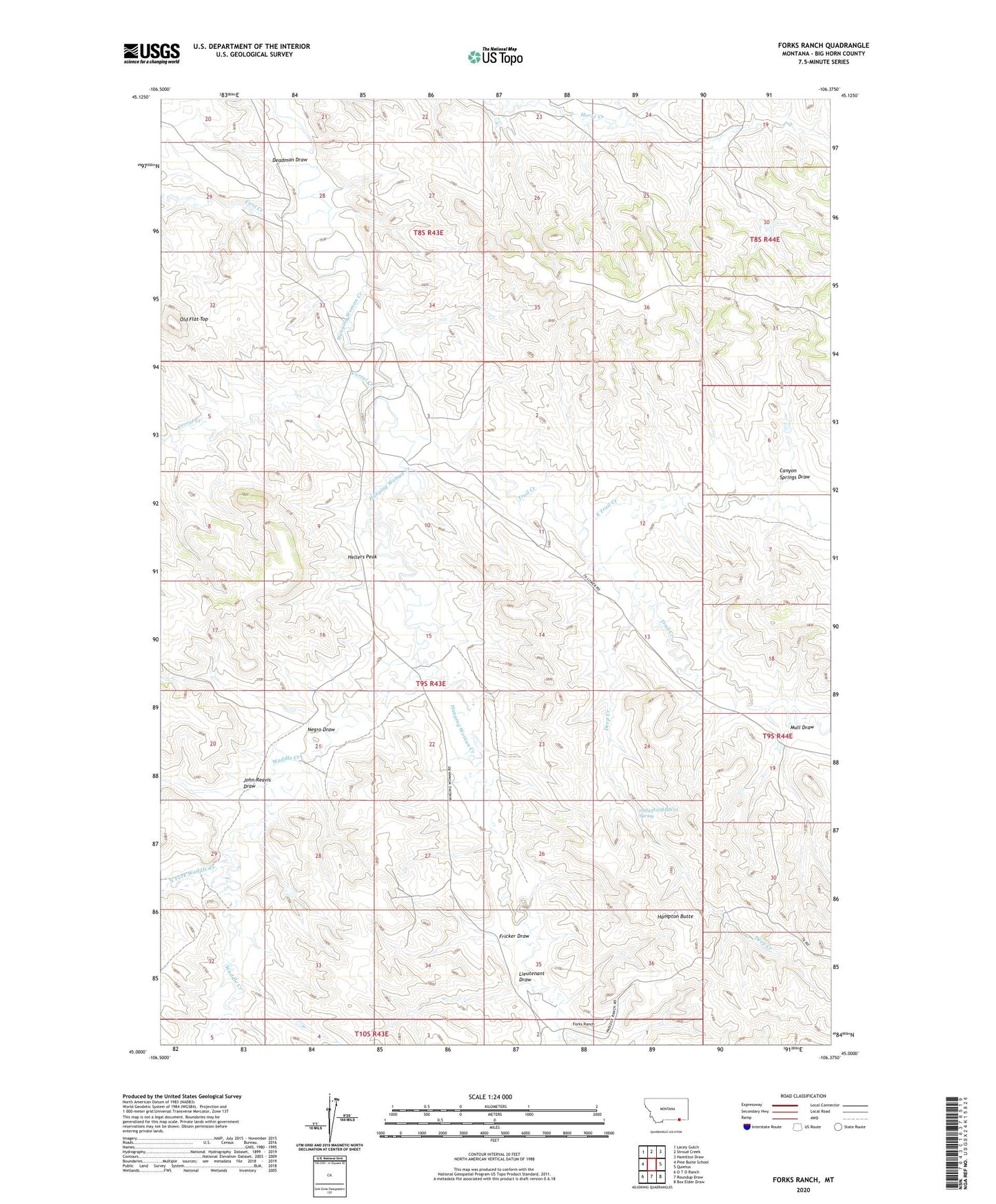
2024 topographic map quadrangle Forks Ranch in the state of Montana. Scale: 1:24000. Based on the newly updated USGS 7.5' US Topo map series, this map is in the following counties: Big Horn. The map contains contour data, water features, and other items you are used to seeing on USGS maps, but also has updated roads and other features. This is the next generation of topographic maps. Printed on high-quality waterproof paper with UV fade-resistant inks.
Quads adjacent to this one:
West: Pine Butte School
Northwest: Lacey Gulch
North: Stroud Creek
Northeast: Hamilton Draw
East: Quietus
Southeast: Box Elder Draw
South: Roundup Draw
Southwest: O T O Ranch
This map covers the same area as the classic USGS quad with code o45106a4.
Contains the following named places: 08S43E20DABA01 Well, 08S43E23CABD01 Well, 08S43E23CABD02 Well, 08S43E23CACA01 Well, 08S43E23CACA02 Well, 08S43E23CACA03 Well, 08S43E23CDAA01 Well, 08S43E23CDAA02 Well, 08S43E23DBCC01 Well, 08S43E23DBDB01 Well, 08S43E25DBBB01 Well, 08S43E25DBBB02 Well, 08S43E28CACD01 Well, 08S43E29DABC01 Well, 08S43E32BBDA01 Well, 08S44E19CBBB01 Well, 08S44E19CBBB02 Well, 08S44E19CBBD01 Well, 08S44E19CBCB01 Well, 08S44E19CBCB02 Well, 08S44E19CBCB03 Well, 08S44E19CBCC01 Well, 09S43E02BBBB01 Well, 09S43E02BBBB02 Well, 09S43E03CBCD01 Well, 09S43E03CBCD02 Well, 09S43E04ABCA01 Well, 09S43E04ABDB01 Well, 09S43E04ABDD01 Well, 09S43E04ABDD02 Well, 09S43E04ABDD03 Well, 09S43E04ACAA01 Well, 09S43E04CBAB01 Well, 09S43E04CBAB02 Well, 09S43E10BBAD01 Well, 09S43E12AACC01 Well, 09S43E12AACC02 Well, 09S43E12ADBB01 Well, 09S43E12ADBB02 Well, 09S43E12ADBD01 Well, 09S43E13BCAA01 Well, 09S43E13CAAA01 Well, 09S43E13CAAA02 Well, 09S43E14DDBB01 Well, 09S43E15CDAB01 Well, 09S43E15DABC01 Well, 09S43E21AADA01 Well, 09S43E21BADA01 Well, 09S43E21BADA02 Well, 09S43E22ACCA01 Well, 09S43E25BADC01 Spring, 09S43E27AAAC01 Well, 09S43E27CDCA01 Well, 09S43E27DABB01 Well, 09S43E29DBAB01 Well, 09S43E35BBCD01 Well, 09S43E35CADC01 Well, 09S44E06BBBB01 Well, 09S44E06BBBB02 Well, 09S44E07BBCC01 Well, 09S44E07BBCC02 Well, 09S44E07BBCC03 Well, 09S44E07BBCC04 Well, 10S43E02AABA01 Well, 10S43E02AABD01 Well, 10S43E02AACB01 Well, 10S43E02ABDA01 Well, 10S43E02ACDA01 Well, 10S43E02ACDC01 Well, 10S43E02BAAA01 Well, Canyon Springs Draw, Corral Creek, Deadman Draw, Deep Creek, East Trail Creek, First Creek, Forks Ranch, Fricker Draw, Hampton Butte, Hellers Peak, John Reavis Draw, Lieutenant Draw, Mull Draw, Negro Draw, North Fork Waddle Creek, Old Flat Top, Trail Creek, Waddle Creek, West Prong Hanging Woman Creek