MyTopo
Hamilton Draw Montana US Topo Map
Couldn't load pickup availability
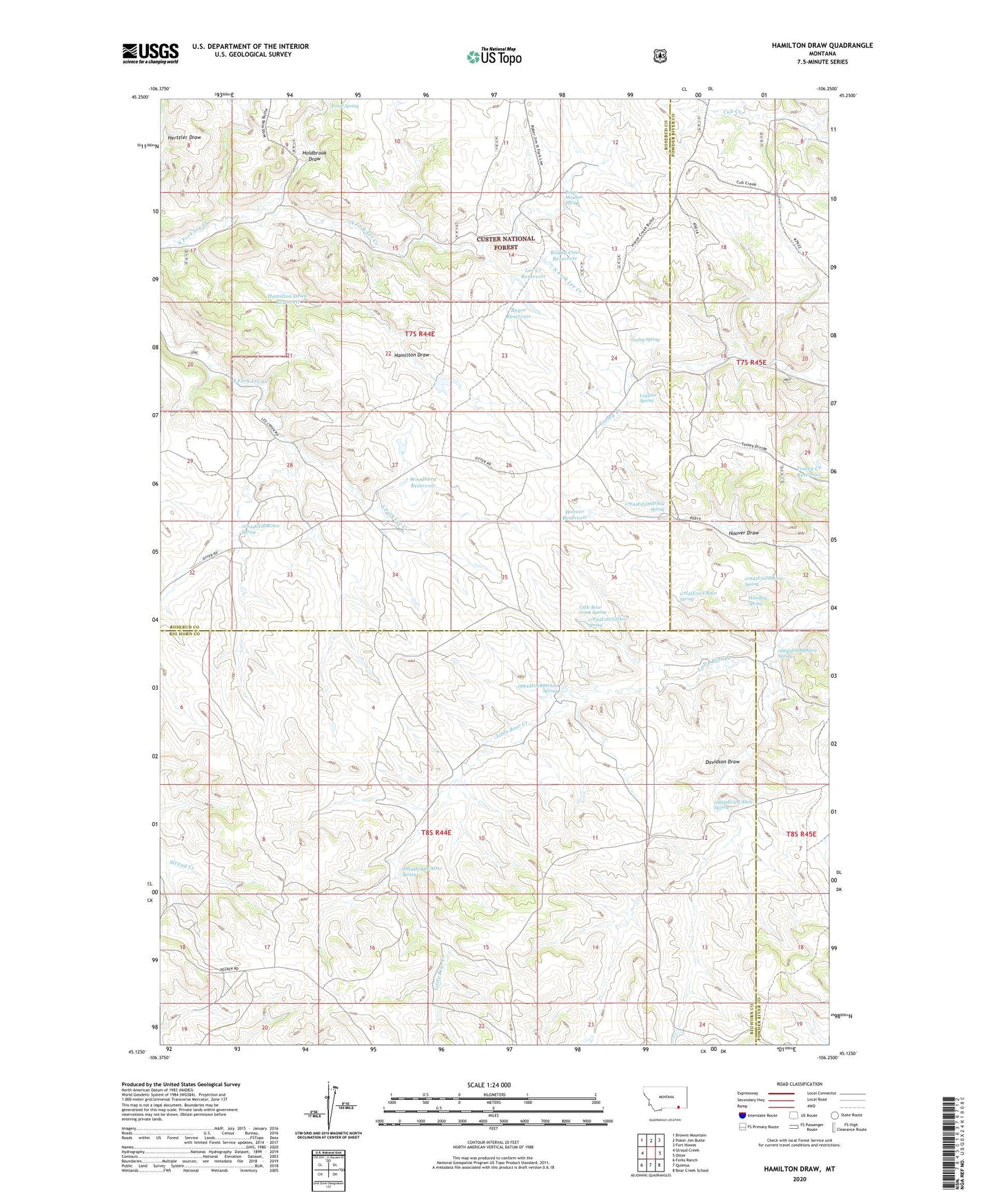
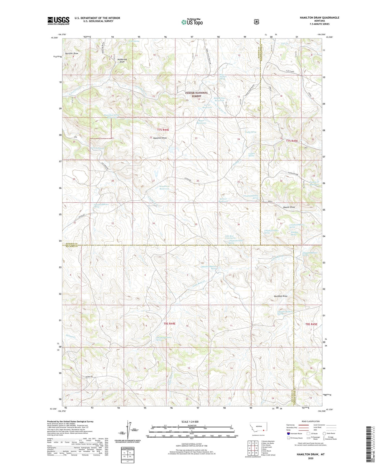
2020 topographic map quadrangle Hamilton Draw in the state of Montana. Scale: 1:24000. Based on the newly updated USGS 7.5' US Topo map series, this map is in the following counties: Rosebud, Big Horn, Powder River. The map contains contour data, water features, and other items you are used to seeing on USGS maps, but also has updated roads and other features. This is the next generation of topographic maps. Printed on high-quality waterproof paper with UV fade-resistant inks.
Quads adjacent to this one:
West: Stroud Creek
Northwest: Browns Mountain
North: Poker Jim Butte
Northeast: Fort Howes
East: Otter
Southeast: Bear Creek School
South: Quietus
Southwest: Forks Ranch
Contains the following named places: 07S44E25DDDA01 Well, 07S44E25DDDA02 Spring, 07S44E26CDDC01 Well, 07S44E33BBCA01 Spring, 07S44E34BAAD01 Well, 07S44E34BAAD02 Well, 07S44E35DCCA01 Well, 07S44E35DCCA02 Well, 07S44E36CCDA01 Spring, 07S44E36DADB01 Well, 07S44E36DADB02 Well, 07S45E19CAAA01 Well, 07S45E31CCBA01 Spring, 07S45E31DBDA01 Spring, 07S45E32BDAB01 Well, 07S45E32BDAD01 Well, 07S45E32BDAD02 Well, 07S45E32CADD01 Well, 07S45E32CADD02 Well, 08S44E02AADC01 Well, 08S44E02ADAB01 Well, 08S44E02BACA01 Well, 08S44E02BACA02 Well, 08S44E02BACD01 Well, 08S44E02BACD02 Well, 08S44E02BACD03 Well, 08S44E02BACD04 Well, 08S44E02BBDA01 Spring, 08S44E02BDAB01 Well, 08S44E03ADDB01 Well, 08S44E03ADDB02 Well, 08S44E03ADDC01 Well, 08S44E03ADDC02 Well, 08S44E03CBBD01 Well, 08S44E03CBBD02 Well, 08S44E05BABB01 Well, 08S44E09DABB01 Well, 08S44E09DABC02 Well, 08S44E09DCAD01 Spring, 08S44E12ACAA01 Spring, 08S44E12ACDC01 Well, 08S44E12ACDC02 Well, 08S44E12ADBC02 Well, 08S44E12ADBD01 Well, 08S44E12ADCA01 Well, 08S44E14AACC01 Well, 08S44E14ABAB01 Well, 08S44E14ABAB02 Well, 08S44E14ABAB03 Well, 08S44E15BCCA01 Well, 08S44E15BCDC01 Well, 08S44E15BCDC02 Well, 08S44E18ABAC01 Well, 08S44E18ABDB01 Well, 08S45E06BBAA01 Spring, 08S45E06BCDA01 Well, 08S45E06BCDB01 Well, Boyce Meadow Spring, Boyce Reservoir, Davidson Draw, Fossil Spring, Gopher, Gopher Post Office, Gopher School, Hamilton Draw, Hamilton Draw Reservoir, Handley Spring, Holdbrook Draw, Hoover Reservoir, Lee Creek Reservoir, Little Bear Creek Spring, Loggins Spring, Round Cow Reservoir, Stevens Number 1 Dam, Tooley Creek Reservoir, Tooley Spring, Woodbury Reservoir