
MyTopo
King Mountain Montana US Topo Map
Couldn't load pickup availability
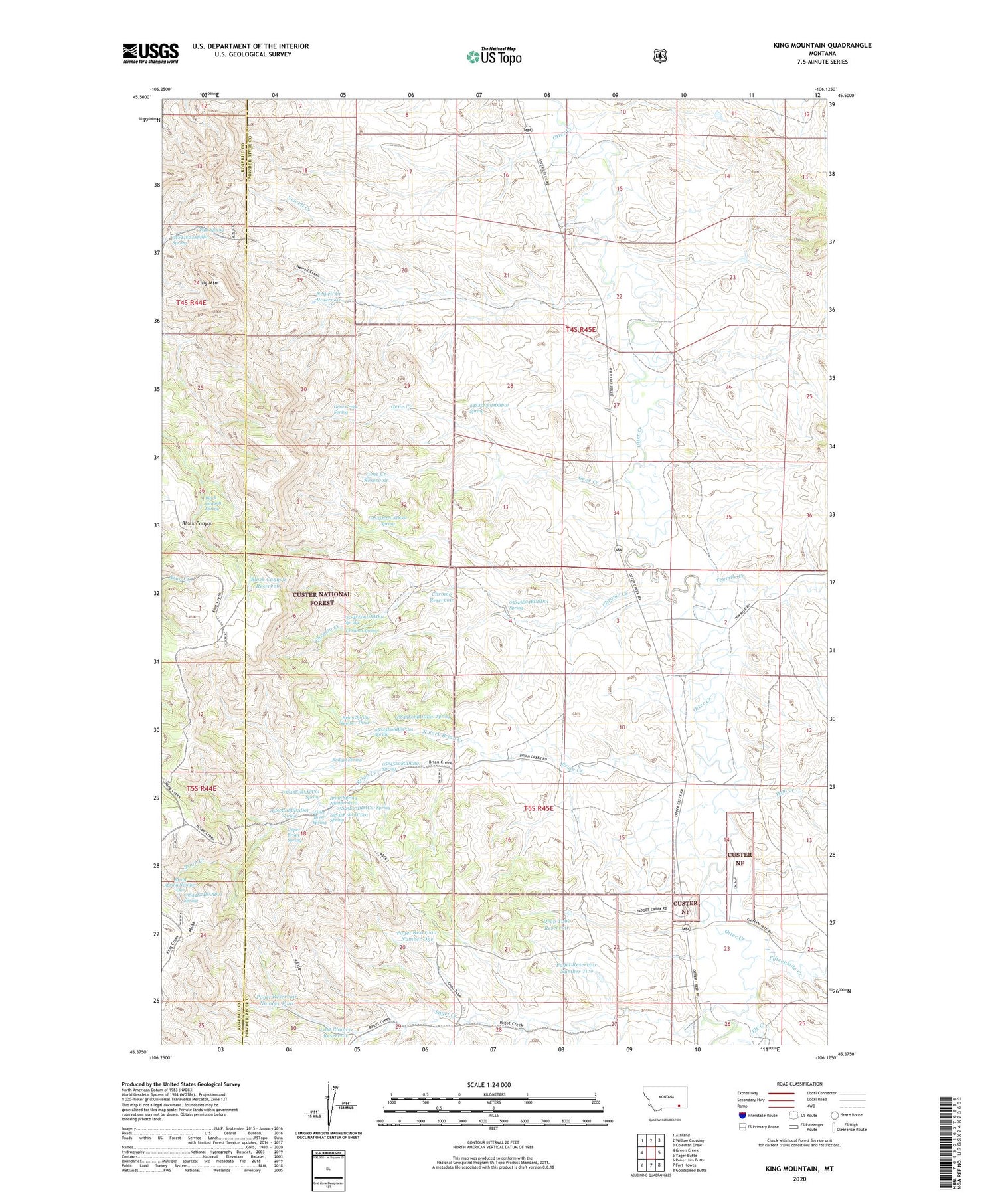
2020 topographic map quadrangle King Mountain in the state of Montana. Scale: 1:24000. Based on the newly updated USGS 7.5' US Topo map series, this map is in the following counties: Powder River, Rosebud. The map contains contour data, water features, and other items you are used to seeing on USGS maps, but also has updated roads and other features. This is the next generation of topographic maps. Printed on high-quality waterproof paper with UV fade-resistant inks.
Quads adjacent to this one:
West: Green Creek
Northwest: Ashland
North: Willow Crossing
Northeast: Coleman Draw
East: Yager Butte
Southeast: Goodspeed Butte
South: Fort Howes
Southwest: Poker Jim Butte
Contains the following named places: 04S44E24ABBB01 Spring, 04S45E09DCAA01 Well, 04S45E09DDAC01 Well, 04S45E09DDBA01 Well, 04S45E10CCBC01 Well, 04S45E14CDCC01 Well, 04S45E15BCDD01 Well, 04S45E15CCAA01 Well, 04S45E15CCAD01 Well, 04S45E15CCBA01 Well, 04S45E15CCDD01 Well, 04S45E15CDCC01 Well, 04S45E15DBBC01 Well, 04S45E16CDAC01 Well, 04S45E17CCDC01 Well, 04S45E19DADC01 Well, 04S45E20CCAD01 Well, 04S45E21CCCA01 Well, 04S45E22ADCC01 Well, 04S45E22BBCC01 Well, 04S45E22CBDC01 Well, 04S45E22CDDD01 Well, 04S45E22DCDB01 Well, 04S45E23CCCB01 Well, 04S45E26AAAA01 Well, 04S45E26BDCA01 Well, 04S45E27ACCD01 Well, 04S45E27DBAB01 Well, 04S45E27DBBA01 Well, 04S45E27DBBA02 Well, 04S45E28AAAB01 Well, 04S45E28ADDA01 Well, 04S45E28BDDD01 Well, 04S45E30DDBB01 Spring, 04S45E32CADC01 Spring, 05S44E24BAAB01 Spring, 05S45E02ACCA01 Well, 05S45E02ACCA02 Well, 05S45E03ACBA01 Well, 05S45E03ACBB01 Well, 05S45E04ABCC01 Well, 05S45E04BBDD01 Well, 05S45E04BDDD01 Spring, 05S45E05AAAB01 Well, 05S45E06DAAD01 Spring, 05S45E07DDAC01 Spring, 05S45E08BBCC01 Well, 05S45E08BDCC01 Spring, 05S45E08BDDD01 Spring, 05S45E08CDCB01 Spring, 05S45E09DDAA01 Well, 05S45E10DDCD01 Well, 05S45E11BBAC01 Well, 05S45E11CDCD01 Well, 05S45E12BDBA01 Well, 05S45E14AAAD01 Well, 05S45E14ACCD01 Well, 05S45E15ADDD01 Well, 05S45E16ADDD01 Well, 05S45E16DBCB01 Well, 05S45E18AACC01 Spring, 05S45E18AACD01 Spring, 05S45E18ADBA01 Well, 05S45E18BDAD01 Spring, 05S45E23ABCA01 Well, 05S45E23ABCA02 Well, 05S45E23ABCB01 Well, 05S45E23ABCB02 Well, 05S45E23ABDA01 Well, 05S45E23ABDA02 Well, 05S45E23ABDA03 Well, 05S45E23BBAA01 Well, 05S45E23BBAA02 Well, 05S45E23BBAA03 Well, 05S45E23BBAA04 Well, 05S45E23CBAC01 Well, 05S45E26BABB01 Well, 05S45E26BCAC01 Well, 05S45E28BBBA01 Well, 05S46E20CBCC01 Well, 59003, Badget Spring, Black Canyon Reservoir, Black Canyon Spring, Brain Spring Number One, Brian Creek, Brian Spring Number Three, Brian Spring Number Two, Brian Well, Chromo Creek, Chromo Reservoir, Chromo Spring, Chromo Well, Dam Creek, Drop Tube Reservoir, Elk Creek, Fifteenmile Creek, Gene Creek, Gene Creek Reservoir, Gene Creek Spring, King Mountain, Last Chance Reservoir, Little Brian Spring, Newell Creek, Newell Creek Reservoir, Newell Creek Well, North Fork Brian Creek, Paget Creek, Paget Reservoir Number Four, Paget Reservoir Number One, Paget Reservoir Number Two, Pass Spring, Tenmile Creek, Upper Brian Spring, Upper Paget Well


