MyTopo
Coleman Draw Montana US Topo Map
Couldn't load pickup availability
Also explore the Coleman Draw Forest Service Topo of this same quad for updated USFS data
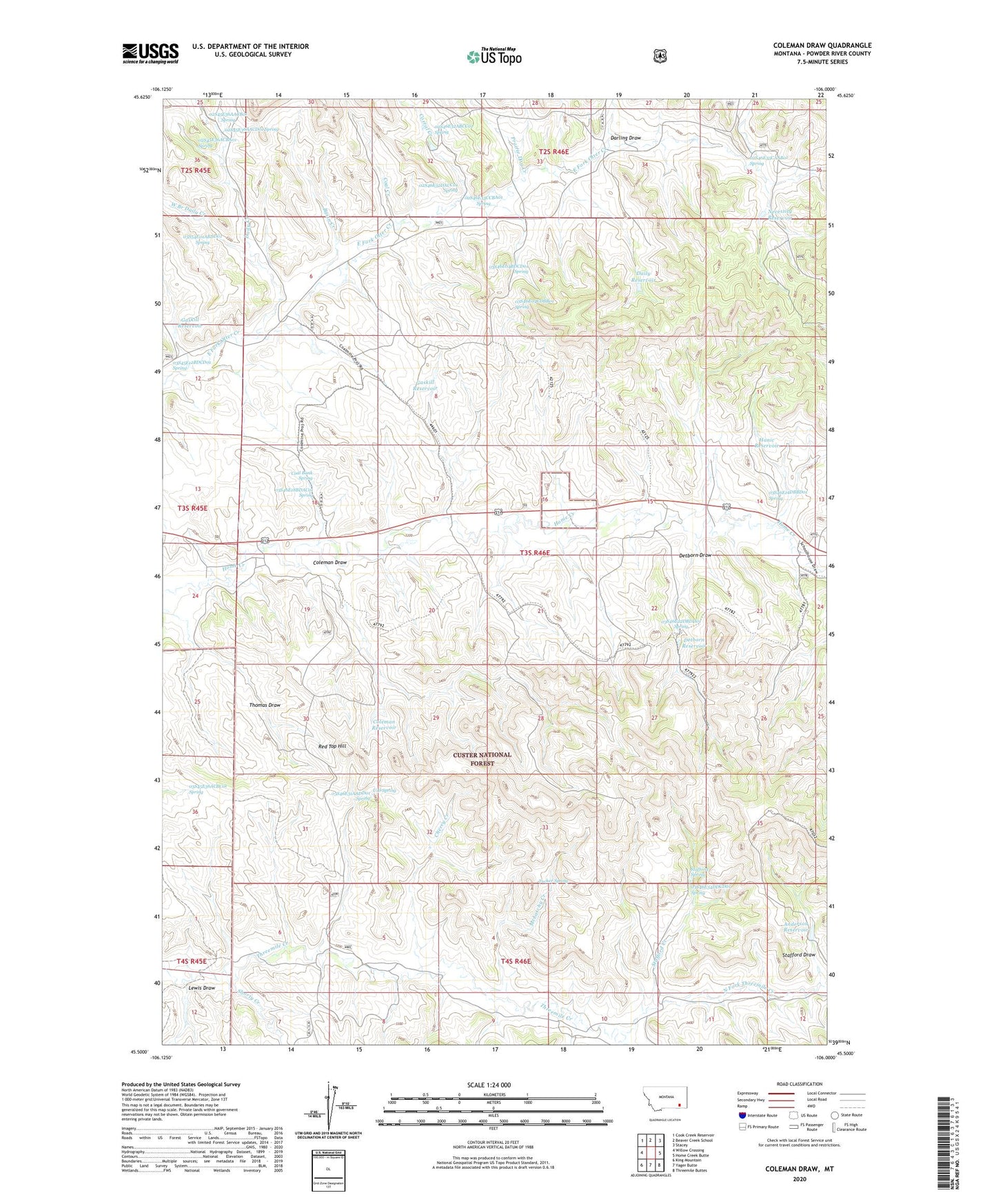
2024 topographic map quadrangle Coleman Draw in the state of Montana. Scale: 1:24000. Based on the newly updated USGS 7.5' US Topo map series, this map is in the following counties: Powder River. The map contains contour data, water features, and other items you are used to seeing on USGS maps, but also has updated roads and other features. This is the next generation of topographic maps. Printed on high-quality waterproof paper with UV fade-resistant inks.
Quads adjacent to this one:
West: Willow Crossing
Northwest: Cook Creek Reservoir
North: Beaver Creek School
Northeast: Stacey
East: Home Creek Butte
Southeast: Threemile Buttes
South: Yager Butte
Southwest: King Mountain
This map covers the same area as the classic USGS quad with code o45106e1.
Contains the following named places: 02S45E36AACB01 Spring, 02S45E36AACD01 Spring, 02S45E36ACBA01 Spring, 02S46E27CCDB01 Well, 02S46E32ABCC01 Spring, 02S46E32DACC01 Spring, 02S46E32DDCD01 Well, 02S46E33CCAB01 Well, 02S46E33CCBA01 Spring, 02S46E33DBAD01 Well, 02S46E34AAAB01 Well, 02S46E34BCAC01 Well, 02S46E34BCCB01 Well, 02S46E35BDDD01 Well, 02S46E35CAAB01 Spring, 02S46E36BCCC01 Well, 02S46E36CBBB01 Well, 03S41E16ADCC01 Well, 03S45E01CDCC01 Well, 03S45E12BDCB01 Well, 03S45E12BDCB02 Well, 03S45E12BDCC01 Well, 03S45E12BDCD01 Spring, 03S45E12BDDB01 Well, 03S45E13DCBC01 Well, 03S45E24ACDA01 Well, 03S45E36ACBC01 Spring, 03S46E04BBBB01 Well, 03S46E04BDCD01 Spring, 03S46E04CDBB01 Spring, 03S46E05AABB01 Well, 03S46E05AABB02 Well, 03S46E05BBCB01 Well, 03S46E06AADB01 Well, 03S46E06AADD01 Well, 03S46E06CCBD01 Well, 03S46E07ADBB01 Well, 03S46E08BDDC01 Well, 03S46E14CBCD01 Well, 03S46E14CBCD02 Well, 03S46E14DBBD01 Spring, 03S46E15CAAA01 Well, 03S46E16ADCC01 Well, 03S46E17ADBC01 Well, 03S46E17DBDC01 Well, 03S46E17DCAA01 Well, 03S46E18BDAC01 Spring, 03S46E18CCCC01 Well, 03S46E18CCCC02 Well, 03S46E19ACBA01 Well, 03S46E19BBAB01 Well, 03S46E19BBBB01 Well, 03S46E20DBAB01 Well, 03S46E21CDBA01 Well, 03S46E22AACB01 Well, 03S46E22CACA01 Well, 03S46E22CBBA01 Well, 03S46E22DBDD01 Spring, 03S46E23AABD01 Well, 03S46E30BCCC01 Well, 03S46E31AADD01 Spring, 03S46E31CBCB01 Well, 03S46E32CDBD01 Well, 03S46E34DDCD01 Spring, 03S46E35ACBA01 Well, 03S54E01ABDD01 Spring, 03S54E25BCBD01 Well, 04S45E01DCD_01 Well, 04S45E12ABBC01 Well, 04S46E04DACA01 Well, 04S46E04DCDC01 Well, 04S46E05BCBC01 Well, 04S46E05CCAA01 Well, 04S46E09BBCA01 Well, 04S46E10BCBA01 Well, 04S46E11BBBA01 Well, Anderson Reservoir, Basin Creek, Bryan Mine, Cherry Creek, Coal Bank Spring, Coal Creek, Coal Mine Project Well, Coleman Draw, Coleman Reservoir, Corral Creek, Daily Creek, Daily Reservoir, Darling Draw, Detborn Draw, Detborn Reservoir, East Pasture Well, Gaskill Reservoir, Hanic Reservoir, Home Creek School, Home Creek Well, Lewis Draw, McLatchy Creek, McLatchy Well, Middle Pasture Well, Necessity Reservoir, North Fork Threemile Creek, Prairie Dog Creek, Red Top Hill, Sheep Wagon Well, Shorty Creek, South Fork Threemile Creek, Stafford Creek, Stafford Draw, Stafford Spring, Stafford Well, Thomas Draw Well, Threemile Well, Tucker Spring, U D Spring, West Branch Daily Creek, Wiechman Well