
MyTopo
Poplar Montana US Topo Map
Couldn't load pickup availability
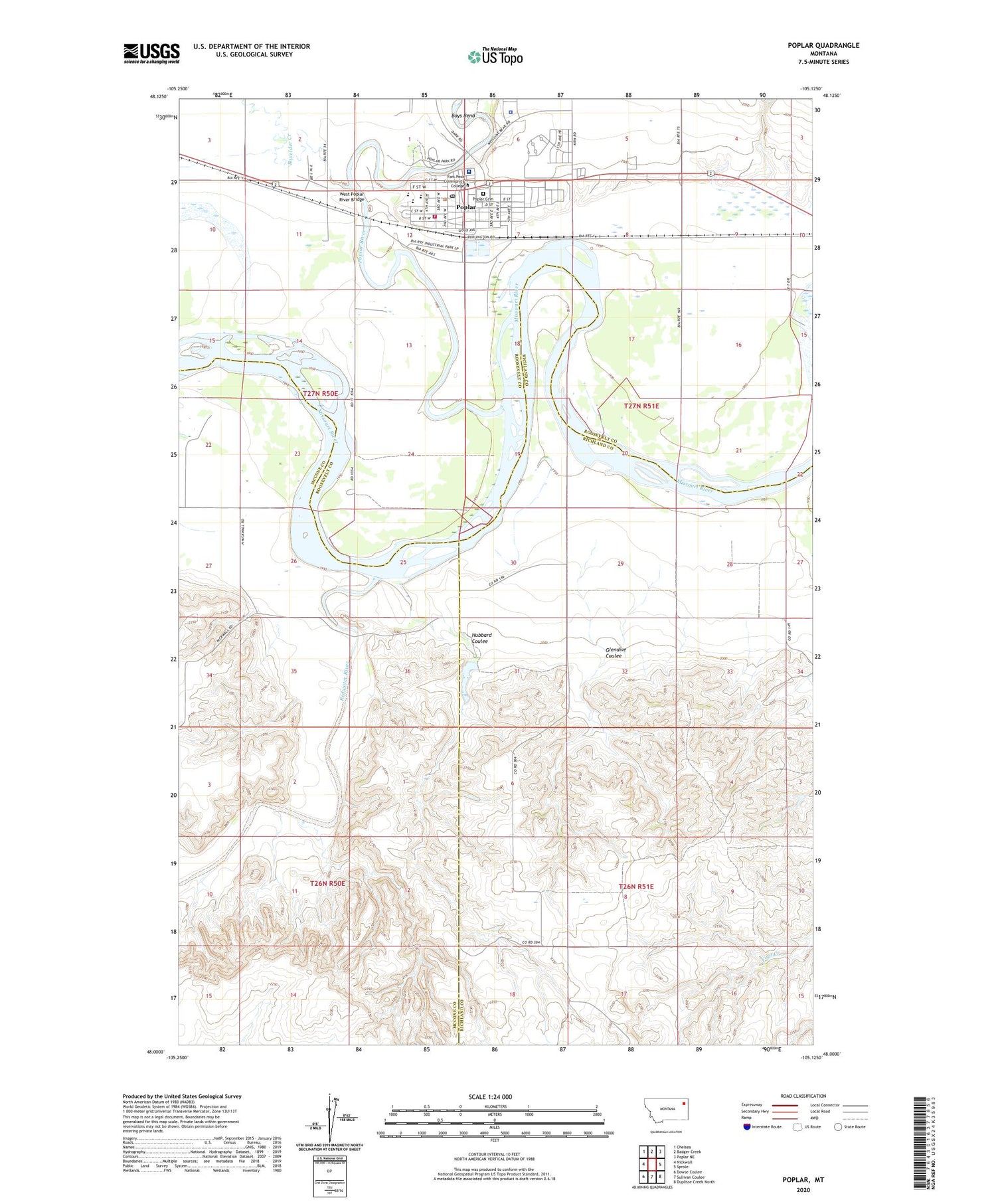
2020 topographic map quadrangle Poplar in the state of Montana. Scale: 1:24000. Based on the newly updated USGS 7.5' US Topo map series, this map is in the following counties: Richland, Roosevelt, McCone. The map contains contour data, water features, and other items you are used to seeing on USGS maps, but also has updated roads and other features. This is the next generation of topographic maps. Printed on high-quality waterproof paper with UV fade-resistant inks.
Quads adjacent to this one:
West: Nickwall
Northwest: Chelsea
North: Badger Creek
Northeast: Poplar NE
East: Sprole
Southeast: Duplisse Creek North
South: Sullivan Coulee
Southwest: Dowse Coulee
Contains the following named places: 27N50E01DC__01 Well, 27N50E01DD__01 Well, 27N50E02CB__01 Well, 27N50E02DC__01 Well, 27N50E02DC__02 Well, 27N50E03DB__01 Well, 27N50E10AB__01 Well, 27N50E11AA__01 Well, 27N50E11AB__01 Well, 27N50E11BB__01 Well, 27N50E11BB__02 Well, 27N50E11DA__01 Well, 27N50E11DB__01 Well, 27N50E11DD__01 Well, 27N50E12AB__01 Well, 27N50E12AB__02 Well, 27N50E12AC__01 Well, 27N50E12AD__01 Well, 27N50E12AD__02 Well, 27N50E12BB__01 Well, 27N50E12CCBC01 Well, 27N50E13BD__01 Well, 27N50E14DDAA01 Well, 27N50E22AC__01 Well, 27N50E23CD__01 Well, 27N50E23DD__01 Well, 27N50E24BC__01 Well, 27N50E24BC__02 Well, 27N50E24BC__03 Well, 27N50E25BD__01 Well, 27N50E25BD__02 Well, 27N50E25DC__01 Well, 27N50E26BA__01 Well, 27N50E27AB__01 Well, 27N50E27AB__02 Well, 27N50E35BA__01 Well, 27N51E04BC__01 Well, 27N51E04CCAA01 Well, 27N51E04CDDD01 Well, 27N51E05CC__01 Well, 27N51E05DB__01 Well, 27N51E07AD__01 Well, 27N51E07BD__01 Well, 27N51E07BD__02 Well, 27N51E07BD__05 Well, 27N51E07DB__03 Well, 27N51E07DB__04 Well, 27N51E08CA__01 Well, 27N51E08CA__02 Well, 27N51E08CA__03 Well, 27N51E08CA__04 Well, 27N51E08DDD_01 Well, 27N51E09CA__01 Well, 27N51E09CC__01 Well, 27N51E10BC__01 Well, 27N51E15BB__01 Well, 27N51E16CD__01 Well, 27N51E16CD__02 Well, 27N51E17DC__01 Well, 27N51E17DC__02 Well, 27N51E18BC__01 Well, 27N51E18BC__02 Well, 27N51E19AD__01 Well, 27N51E21BB__01 Well, 27N51E27BC__01 Well, 27N51E27CB__01 Well, 27N51E27CBBB01 Well, 27N51E28CA__01 Well, 27N51E28DB__01 Well, 27N51E28DB__02 Well, 27N51E28DB__03 Well, 27N51E29AB__01 Well, 27N51E29BB__01 Well, 27N51E29BBCB01 Well, 27N51E29BC__01 Well, 27N51E29BD__01 Well, 27N51E30AC__01 Well, 27N51E30AD__01 Well, 27N51E30AD__02 Well, 27N51E32BA__01 Well, American Legion Park, Arthur, Arthur Post Office, Arthur School, Assembly of God Church, Assiniboine and Sioux Fort Peck Tribal Police, Boxelder Creek, Boys Bend, Brethren Church, Camp Poplar River, Chief Drive In, Church of the Nazarene, City of Poplar, Columbia Grain International Incorporated Elevator, Dale Hospital, Farmers Elevator Company Elevator, First Baptist Church, First Presbyterian Church, Fort Jackson, Fort Peck Community College, Fort Peck Indian Reservation Historical Marker, Fort Peck Tribal Museum, Fort Poplar, Glendive Coulee, Hubbard Coulee, Indian Health Hospital, Indian Mission - Church of America, Lindsey Memorial Presbyterian Church, Malcolm Clarks Fort, Native American Educational Services College, Northeast Montana Health Services - Poplar Community Hospital, Our Lady of Lourdes Church, Peavey Company Elevator, Pentecostal Church of God Full Gospel Church, Poplar, Poplar Cemetery, Poplar City Hospital, Poplar City Library, Poplar Community Nursing Home, Poplar Elementary School, Poplar Elevator, Poplar Museum, Poplar Police Department, Poplar Post Office, Poplar River, Poplar Sewage Disposal Pond Dam, Poplar Volunteer Fire Department, Redwater River, Riverside Family Clinic, Roosevelt County Sheriff's Office Substation, Saint Johns Lutheran Church, Smiths Mobile Park, The Church of Jesus Christ of Latter Day Saints, United Grain Corporation Elevator, Voorhees Dam, West Poplar River Bridge, Winter Truesdal-Dirks Company Elevator


