MyTopo
Stevensville Montana US Topo Map
Couldn't load pickup availability
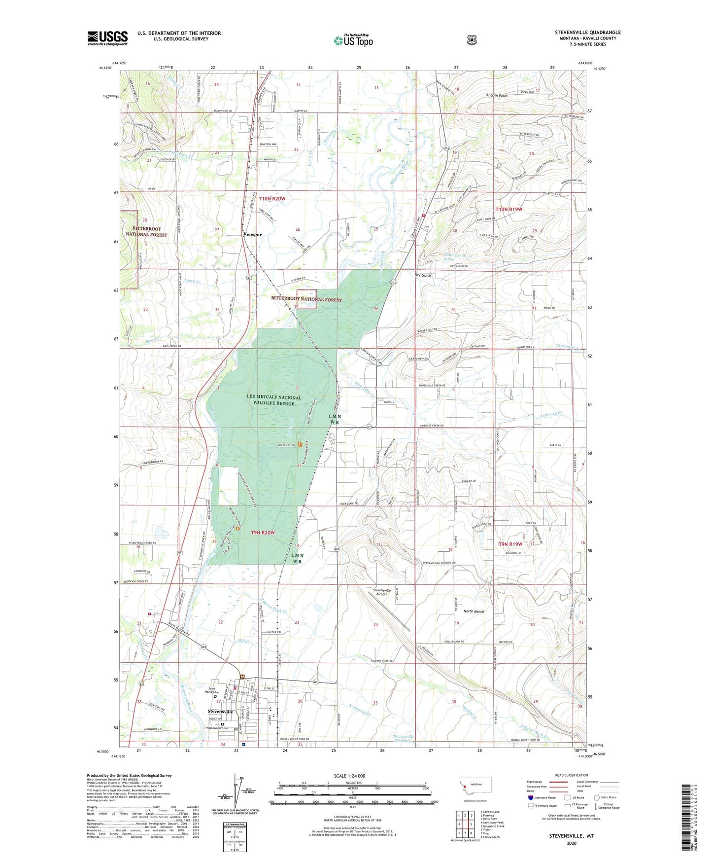
2020 topographic map quadrangle Stevensville in the state of Montana. Scale: 1:24000. Based on the newly updated USGS 7.5' US Topo map series, this map is in the following counties: Ravalli. The map contains contour data, water features, and other items you are used to seeing on USGS maps, but also has updated roads and other features. This is the next generation of topographic maps. Printed on high-quality waterproof paper with UV fade-resistant inks.
Quads adjacent to this one:
West: Saint Mary Peak
Northwest: Carlton Lake
North: Florence
Northeast: Davis Point
East: Grayhorse Creek
Southeast: Corley Gulch
South: Bing
Southwest: Victor
Contains the following named places: 09N19W05AD__01 Well, 09N19W05CA__01 Well, 09N19W06CA__01 Well, 09N19W29CC__01 Well, 09N19W30CC__01 Well, 09N20W01AC__01 Well, 09N20W01DA__01 Well, 09N20W04AB__01 Well, 09N20W10AD__02 Well, 09N20W10BC__01 Well, 09N20W11ABCC01 Well, 09N20W12BBBB01 Well, 09N20W12CB__01 Well, 09N20W15CA__02 Well, 09N20W15DD__01 Well, 09N20W16DC__01 Well, 09N20W21AD__01 Well, 09N20W21ADB_01 Well, 09N20W21ADB_02 Well, 09N20W23AD__01 Well, 09N20W23DA__01 Well, 09N20W25BB__01 Well, 09N20W26BA__01 Well, 09N20W26BA__03 Well, 09N20W26BA__04 Well, 09N20W26BACC01 Well, 09N20W26BACC02 Well, 09N20W27AACC01 Well, 09N20W27ABCC01 Well, 09N20W27CD__01 Well, 09N20W27DBCD01 Well, 09N20W27DCBA01 Well, 09N20W27DCBB01 Well, 09N20W27DDBA01 Well, 09N20W28BD__01 Well, 09N20W28DB__01 Well, 10N19W17DBCA01 Well, 10N19W18CA__01 Well, 10N19W29CC__01 Well, 10N19W30CD__01 Spring, 10N20W13CC__01 Well, 10N20W15DC__01 Well, 10N20W22BC__01 Well, 10N20W22CC__01 Well, 10N20W23CB__01 Well, 10N20W26AB__01 Well, 10N20W27AD__01 Well, 10N20W34CD__01 Well, 10N20W35BB__01 Well, 59870, Ambrose Creek, Antrim Lookout, Antrim Point, Apple Blossom Court, Auriga Dam, Back to Health Chiropractic Clinic, Bass, Bass Creek, Bass Creek Fishing Access Site, Bass School, Bitter Root, Bitter Root Post Office, Bitterroot Court, Bitterroot Valley Special Education Cooperative, Brooks Creek, Ckye Field, Community Baptist Church, Dry Gulch, Erickson, First Baptist Church of Stevensville, Fort Owen, Fort Owen Historical Marker, Fort Owen Post Office, Fort Owen State Park, Haolden, Historic Saint Marys Mission, Iron Cap Creek, Jehovah Witnesses Kingdom Hall, Jesus Community Church, Kenspur, Kootenai Creek, Larry Creek, Lee Metcalf National Wildlife Refuge, Lee Metcalf National Wildlife Refuge Airport, Lewis and Clark Park, LIght of the Valley Assembly of God Church, Maplewood Cemetery, McCalla Creek, McKeen, McNulty Chiropractic Clinic, Miles, Mill Creek, North Bench, North Burnt Fork Creek, North Swamp Creek, North Valley Church of Christ, North Valley Nursing Home, North Valley Public Library, Poker Joe Sportsman Access, Ravalli County Sheriff's Office Substation, Ravalli Medical Clinic, Saint Mary Mission, Saint Marys Cemetery, Saint Marys Church, Saint Stephens Episcopal Church, Sharrott Creek, South Swamp Creek, Spring Creek, Stevensville, Stevensville Airport, Stevensville Ambulance, Stevensville City Fire District - Burnt Fork Station, Stevensville Division, Stevensville Medical Clinic, Stevensville Museum, Stevensville Police Department, Stevensville Post Office, Stevensville Public Schools, Stevensville Reservoir, Stevensville Rural Fire District - West Side Station, Stevensville Sewage Lagoon Dam, Stevensville United Methodist Church, Stevensvillers Ranger Station, Supply Ditch, Sweeney Creek, The Church of Jesus Christ of Latter Day Saints, Three Mile Fire District Station 2, Threemile Creek, Town of Stevensville, Whitetail Golf Course