MyTopo
White Sulphur Springs Montana US Topo Map
Couldn't load pickup availability
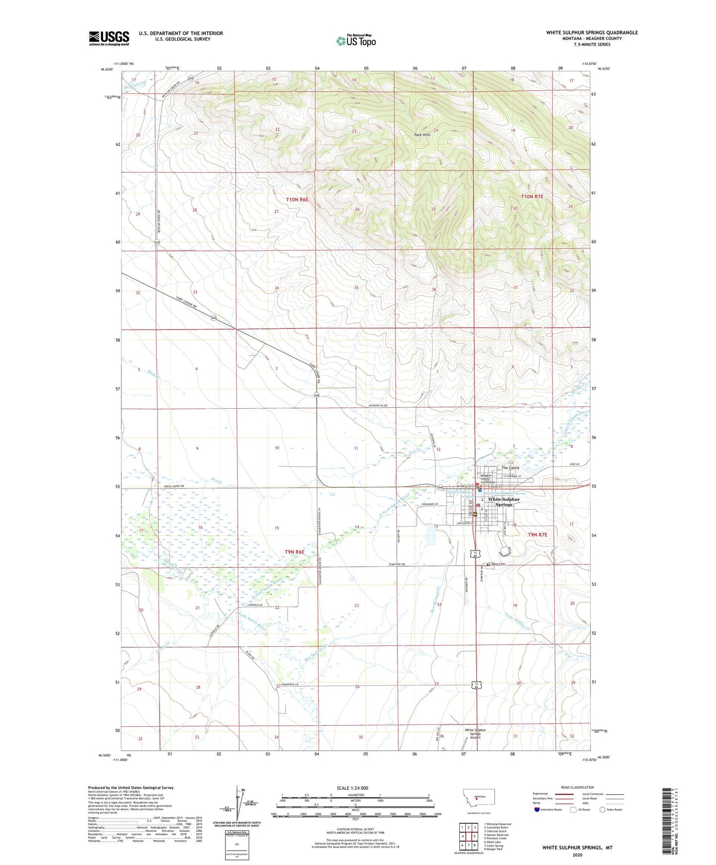
2020 topographic map quadrangle White Sulphur Springs in the state of Montana. Scale: 1:24000. Based on the newly updated USGS 7.5' US Topo map series, this map is in the following counties: Meagher. The map contains contour data, water features, and other items you are used to seeing on USGS maps, but also has updated roads and other features. This is the next generation of topographic maps. Printed on high-quality waterproof paper with UV fade-resistant inks.
Quads adjacent to this one:
West: Hanson Reservoir
Northwest: Whitetail Reservoir
North: Coxcombe Butte
Northeast: Charcoal Gulch
East: Pinchout Creek
Southeast: Manger Park
South: Catlin Spring
Southwest: Alkali Lake
Contains the following named places: 09N06E02AC__01 Well, 09N06E02D___01 Well, 09N06E05AC__01 Well, 09N06E09CD__01 Well, 09N06E09D___01 Well, 09N06E10A___01 Well, 09N06E10D___01 Well, 09N06E12ACC_01 Well, 09N06E12CA__01 Well, 09N06E13AAA_01 Well, 09N06E13D___01 Well, 09N06E14B___01 Well, 09N06E14BB__01 Well, 09N06E14DA__01 Well, 09N06E17A___01 Well, 09N06E21C___01 Well, 09N06E22BD__01 Well, 09N06E22CB__01 Well, 09N06E24B___01 Well, 09N06E24BB__01 Well, 09N06E24BB__02 Well, 09N06E24DA__01 Well, 09N06E25BA__01 Well, 09N06E25DA__01 Well, 09N06E25DC__01 Well, 09N06E26DC__01 Well, 09N06E28AA__01 Well, 09N06E28CA__01 Well, 09N07E07CA__01 Well, 09N07E07CD__01 Well, 09N07E08C___01 Well, 09N07E18BBB_01 Spring, 09N07E18BBBD01 Spring, 09N07E19C___01 Well, 09N07E19C___02 Well, 10N06E17DC__01 Well, 10N06E22C___01 Well, 10N06E28C___01 Well, American Lutheran Church, Arrowhead Meadows, Christian and Missionary Alliance Church, City of White Sulphur Springs, Conestoga Campground, Cooks Creek, Doak Trailer Court, Douglas Studs, First Presbyterian Church, Hot Springs Creek, Jehovahs Witnesses, Jerry Mallo Trailer Court, Kaldor Park, Lone Willow Creek, Mayn Cemetery, Meagher County, Meagher County Courthouse, Meagher County Office of Sheriff, Meagher County Rural Fire Department, Meagher County-City Library, Medical Arts of White Sulphur Springs, Mikesell Trailer Court, Mill Siding, Mountain View Clinic, Mountain View Memorial Nursing Home, Mountainview Baptist Church, Mountainview Medical Center, North Fork Smith River, Park Hills, Rader Park, Richards Trailer Court, Saint Bartholomews Catholic Church, Seventh Day Adventist Church, South Fork Smith River, Spring Creek, Springs Campground, The Castle, White Sulphur Springs, White Sulphur Springs Airport, White Sulphur Springs City Park, White Sulphur Springs Elementary School, White Sulphur Springs Emergency Medical Services, White Sulphur Springs Fire Department, White Sulphur Springs High School, White Sulphur Springs Post Office, White Sulphur Springs Ranger Station Heliport