MyTopo
Kearney Nebraska US Topo Map
Couldn't load pickup availability
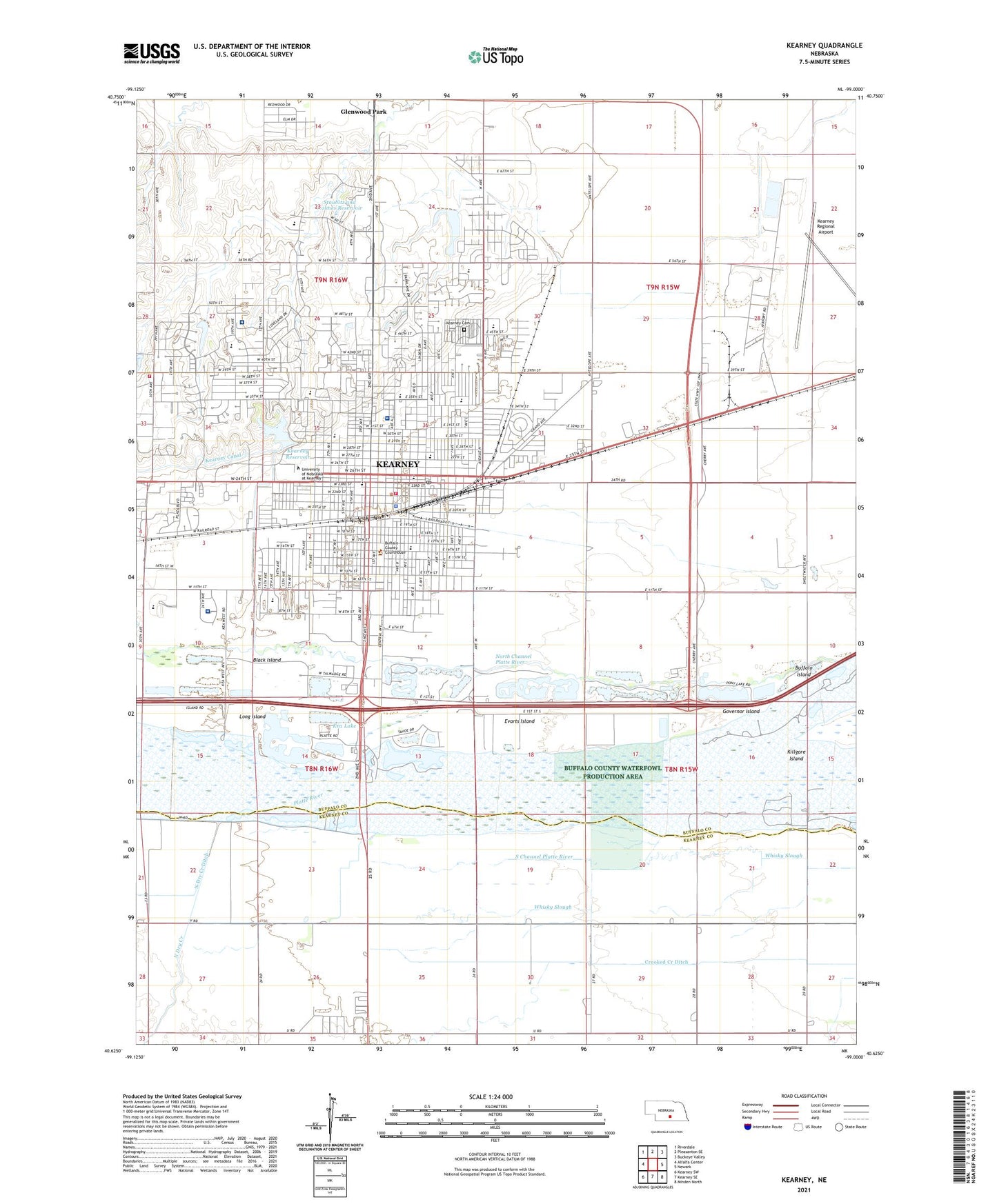
2021 topographic map quadrangle Kearney in the state of Nebraska. Scale: 1:24000. Based on the newly updated USGS 7.5' US Topo map series, this map is in the following counties: Buffalo, Kearney. The map contains contour data, water features, and other items you are used to seeing on USGS maps, but also has updated roads and other features. This is the next generation of topographic maps. Printed on high-quality waterproof paper with UV fade-resistant inks.
Quads adjacent to this one:
West: Alfalfa Center
Northwest: Riverdale
North: Pleasanton SE
Northeast: Buckeye Valley
East: Newark
Southeast: Minden North
South: Kearney SE
Southwest: Kearney SW
Contains the following named places: Apollo Park, Art Annex, Black Island, Bruner Hall, Bryant School, Budget Motel and Campground, Buffalo County Courthouse, Buffalo County Fairgrounds, Buffalo County Sheriff Department, Buffalo County Waterfowl Production Area, Buffalo Island, Buffalo Ridge Golf Course, Calvary Baptist Church, Calvin T Ryan Library, Cambridge Court, Campus Lutheran Ministry, Case Hall, Centennial Park, Centennial Towers East, Centennial Towers West, Central Community College - Practical Nursing, Central Elementary School, Church of Christ, Church of the Nazarene, City of Kearney, Collins Park, Communications Center Building, Conrad Hall, Contemporary Obstetrics and Gynecology, Copeland Hall, Cornhusker Trailer Court, Countryside Christian Church, Countryside Mobile Park, Crooked Creek, Crooked Creek Ditch, Cushing Colosseum, Dobytown Historical Marker, Dryden Park, East Lawn Mobile Home Estates, Education Center, Election Precinct 1, Election Precinct 10, Election Precinct 11, Election Precinct 12, Election Precinct 13, Election Precinct 14, Election Precinct 2, Election Precinct 27, Election Precinct 29, Election Precinct 3, Election Precinct 4, Election Precinct 5, Election Precinct 6, Election Precinct 7, Election Precinct 8, Election Precinct 9, Emerson School, Evangelical Free Church, Evarts Island, Faith United Methodist Church, Family of Christ Lutheran Church, Family Practice Association Building, Fine Arts Building, First Baptist Church, First Christian Church, First Church of Christ Scientist, First Church of God, First Lutheran Church, First Presbyterian Church, First United Methodist Church, Fort Kearney, Fort Kearney Historical Marker, Fort Kearney State Historical Park, Fort Kearney Trail, Foster Field, Founders Hall, Frank House, Glenwood Mobile Home Park, Glenwood Park, Glenwood Post Office, Good Samaritan Heliport, Good Samaritan Hospital, Good Shepherd Lutheran Church, Governor Island, Grace Fellowship Church, Great Platte River Road Historical Marker, Harmon Park, Harvey Park, Health and Sports Center, Heartland Chiropractic Clinic, Hilltop Mall, Historic Kearney Historical Marker, Holy Cross Lutheran Church, Horizon Middle School, Ihle Chiropractic Center, Immanuel Baptist Church, Jaycees Park, Jehovahs Witnesses Kingdom Hall, Kea Lake, KEAA-FM (Kearney), Kearney, Kearney Area Childrens Museum, Kearney Army Air Field, Kearney Auto Raceway Park, Kearney Baptist Church, Kearney Bone and Joint Clinic, Kearney Catholic High School, Kearney Cemetery, Kearney Christian School, Kearney City, Kearney City Post Office, Kearney Clinic, Kearney Country Club, Kearney Dam, Kearney Drive-In Theater, Kearney Eye Institute, Kearney Foot Clinic, Kearney Orthopedic and Fracture Clinic, Kearney Police Department, Kearney Post Office, Kearney Public Library, Kearney Regional Airport, Kearney Regional Medical Center, Kearney Reservoir, Kearney Rest Area - Westbound, Kearney Senior High School, Kearney Urology Center, Kearney Volunteer Fire Department Station 1, Kearney Volunteer Fire Department Station 2, Kearney Volunteer Fire Department Training Site, Kenwood School, KGFW-AM (Kearney), KRNY-FM (Kearney), KSCV-FM (Kearney), Lake Kearney, Ludden Hall, Mantor Hall, Martin Hall, Meadowlark Elementary School, Memorial Diamond Park, Mens Dorm, Mid-Nebraska Ear Nose and Throat Associates, Mother Hull Home, Mount Carmel Home, Museum of Nebraska Art, Nebraska Wind Sculpture, Nebraskan Student Union, New Life Assembly of God Church, Newman Center, North Dry Creek, North Dry Creek Ditch, Northeast School, Ockinga Center, Open Bible Church, Otto Olsen Building, Park School, Pentecostal Church of Kearney, Pioneer Park, Platte Valley Foot Clinic, Platte Valley Medical Group, Prairie View Elementary School, Prairie View Estates, Prince of Peace Church, Randall Hall, Richard Young Hospital, Riverside Mobile Home Court, R-Villa Courts, Saint George Orthodox Church, Saint James Catholic Church, Saint Johns Good Samaritan Center, Saint Lukes Episcopal Church, Saint Lukes Good Samaritan Village, Salvation Army, Seventh Day Adventist Church, Southeast Park, Staubitz and Holmes Dam, Staubitz and Holmes Reservoir, Stone Public School, Stout Hall, Student Affairs Building, Sunrise Middle School, Ted Baldwin Park, The Church of Jesus Christ of Latter Day Saints, The Great Plains Historical Marker, Thomas Hall, Township of Center, Trails and Rails Museum, Trails West Sports Medicine Center, Trinity Presbyterian Church, University of Nebraska at Kearney, University of Nebraska at Kearney Historical Marker, University Residence North, University Residence South, Valley View Trailer Court, Victory Foursquare Church, Vietnam Memorial, Walker Channel, Welch Hall, West Center Building, West Lincolnway Park, Whittier School Junior High School, Windy Hills Elementary School, Yanney-Peterson Memorial Carillon Bell Tower, Zion Lutheran Church, Zion Lutheran Church School, ZIP Code: 68849