
MyTopo
Yankee Blade Nevada US Topo Map
Couldn't load pickup availability
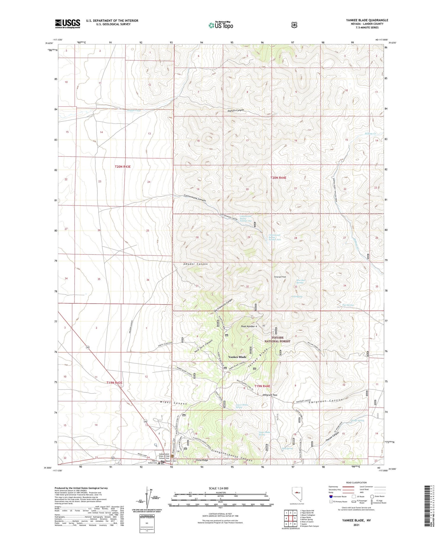
2021 topographic map quadrangle Yankee Blade in the state of Nevada. Scale: 1:24000. Based on the newly updated USGS 7.5' US Topo map series, this map is in the following counties: Lander. The map contains contour data, water features, and other items you are used to seeing on USGS maps, but also has updated roads and other features. This is the next generation of topographic maps. Printed on high-quality waterproof paper with UV fade-resistant inks.
Quads adjacent to this one:
West: Vigus Butte
Northwest: Vigus Butte NW
North: Vigus Butte NE
Northeast: Mount Callaghan
East: Barton Spring
Southeast: Simpson Park Canyon
South: Austin
Southwest: West of Austin
Contains the following named places: 1862 Overland, Amador, Amador Canyon, Amador Mine, Amador Post Office, Amazonia Mine, American Silver Mine, Aurora West Mine, Austin Elementary School, Austin High School, Austin Indian Cemetery, Austin Junior High School, Baldy Mine, Barclay and Smith Mine, Beiss Mine, Black Eagle Mine, Blind Ledge Mine, Blue Jacket Mine, Bonanza Little Mine, Boston and Nevada Mine, Boulder Mine, Bright Star Mine, Bull Dog Mine, Burtons Ranch, Butte Mill, Calvary Cemetery, Cambrian and New York Mine, Cameron Mine, Castle Mountain Mine, Chase Tunnel, Chicago Mine, Cold Spring, Collins Mine, Columbia Mine, Confidence Hoisting Works, Confidence Mine, Cooper Mine, Cottonwood Canyon, Cottonwood Spring Number One, Cottonwood Spring Number Two, Crow Canyon Mine, Cullin Mine, Daisy Mine, Detroit Mine, Double H Mine, Eathan Allen Mine, Elkhorn Canyon, Emigrant Canyon, Emigrant Pass, Engineer Tunnel, Engstrom Mine, Esperanza Mine, Esther Mine, Farrell Mine, Flora Mine, Florida West Mine, Freehold Mine, Gault Mine, Girard Mine, Gold Hill Mine, Gold Park Mine, Good Hope Mine, Govich and Clark Mine, Green Stone Mine, Grimes Mine, Grove Mine, Groves Mine, Hamlet Mine, Harnett Lane Mine, Hatfield Mine, Hatfield Tunnel Mine, Hattie Mill, Hercules Austin Mine, Homestake Mine, Homeward Bound Mine, Hope Mine, Hubbard Mine, Idora Mine, Independent Order of Odd Fellows Cemetery, Jenkins Mine, Jewett Mine, Keystone Mill, Keystone Mine, Kihock Mine, Kilborn Tunnel, Kling and Ford Mine, Kling and Kelly Mine, Klondike Mine, Lady Adams Mine, Laurium Mine, Lee and Lund Mine, Lemaire Mine, Limelight Mine, Lindsay and Shepard Mine, Lombardie Mine, Lone Star Mine, Lower Midas Spring, Luna Mine, Maggie Mine, Mahoney Mine, Maple Leaf Mine, Maricopa Mine, Masonic Cemetery, Maximillian Mine, McCall Mine, McCann and Patrick Mine, McFee Mine, Merced Mine, Merritt Mine, Mettacom Mill, Midas Canyon, Midas Mine, Morning Star Mine, Morris and Caple Tunnel, Mud Spring, Mullin Mine, Naid Queen Mine, Nevada Boy Mine, New Strike Mine, New York Canyon, Niagra Mine, Nicklas Mine, North River Mine, North Silver King Mine, Occidental Mine, O'Kane Mine, O'Neil Mine, Ontario Mine, Orr Mine, Patriot Tunnels, Peak Number 4, Phoenix Mine, Pipe Springs, Ravenswood Station, Red Mine, Reed and Wilbur Mine, Reese River Mining District, Revenue Mine, Ribo Mine, Roberts Mine, Roosevelt Mine, Rose Bud Springs, Ryan Mine, Sam Brannan Mine, San Francisco Canyon, San Francisco Mine, San Lorenzo Mine, Saybrook Mine, Schoof Mine, Sherman Hoisting Work, Silver Belt Ledge Mine, Silver Eagle Shaft, Silver Moon Mine, Sinnott and Casey Mine, Slaughterhouse Canyon, Sonoma Gold and Silver Mine, Sonora Mine, Southall and O'Kane Mine, Star of Nevada Tunnel, Switzerland Mine, Telegraph Peak, Thompson Mine, Thorpe Canyon, Thorpe Spring, Toulumne Mine, Trask and Woods Mine, True Blue Tunnel, Turner Mine, Upper Midas Spring, Walsh and Gayhart Mine, Watt Shaft, West Point Mine, Whitlach Yankee Blade Mine, Willard and Osborne Mine, Williams Mine, Yankee Blade, Yankee Blade Mine, Yates and Yandel Mine


