MyTopo
Mount Washington New Hampshire US Topo Map
Couldn't load pickup availability
Also explore the Mount Washington Forest Service Topo of this same quad for updated USFS data
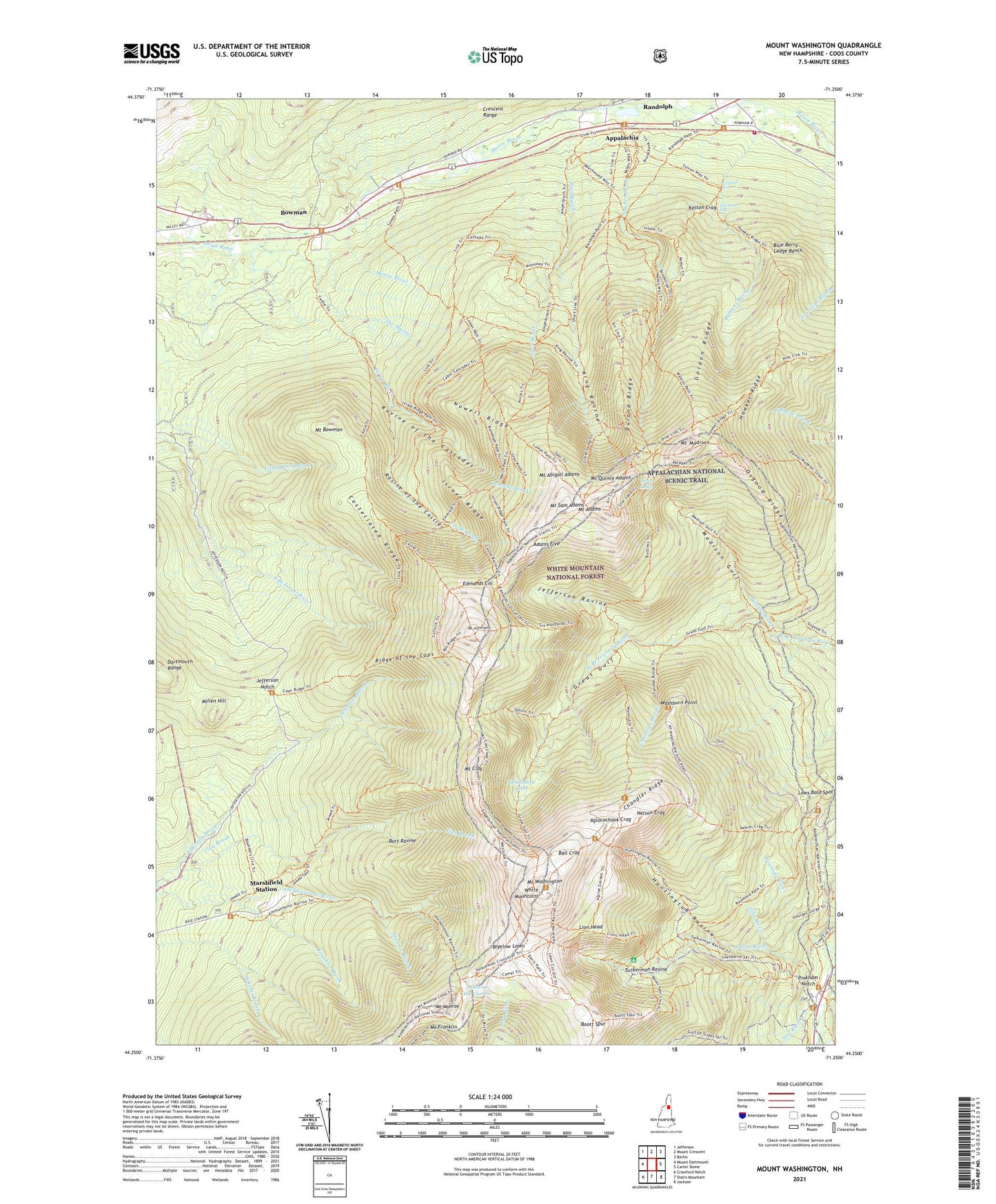
2024 topographic map quadrangle Mount Washington in the state of New Hampshire. Scale: 1:24000. Based on the newly updated USGS 7.5' US Topo map series, this map is in the following counties: Coos. The map contains contour data, water features, and other items you are used to seeing on USGS maps, but also has updated roads and other features. This is the next generation of topographic maps. Printed on high-quality waterproof paper with UV fade-resistant inks.
Quads adjacent to this one:
West: Mount Dartmouth
Northwest: Jefferson
North: Mount Crescent
Northeast: Berlin
East: Carter Dome
Southeast: Jackson
South: Stairs Mountain
Southwest: Crawford Notch
This map covers the same area as the classic USGS quad with code o44071c3.
Contains the following named places: Adams Five, Adams Slide Trail, Agiocochook Crag, Air Line, Alpine Garden Trail, Alpine Gardens, Appalachia, Ball Crag, Bigelow Lawn, Blue Berry Ledge Bench, Boott Spur, Boott Spur Trail, Bowman, Bowman Bose Camp, Bumpus Brook, Burt Ravine, Buttress Trail, Carlton Brook, Cascade Brook, Castellated Ridge, Castle Brook, Castle Path, Chandler Brook, Chandler Ridge, Chandlers Purchase, Clay Brook, Cold Brook, Coosauk Fall, Cutler River, Davis Path, Durand Ridge, Edmands Col, Franklin Brook, Gordon Ridge, Great Gulf, Great Gulf Shelter, Great Gulf Wilderness, Gulfside Trail, Hermit Lake, Hitchcock Falls, Howker Ridge, Howker Ridge Path, Huntington Ravine, Israel Ridge, Jefferson Notch, Jefferson Ravine, Jewell Trail, Kelton Crag, King Ravine, Lakes of the Clouds, Lion Head, Low and Burbanks Grant, Lowes Path, Lows Bald Spot, Madison Gulf, Marshfield Station, Millen Hill, Monroe Brook, Mount Abigail Adams, Mount Adams, Mount Bowman, Mount Clay, Mount Franklin, Mount Jefferson, Mount Madison, Mount Monroe, Mount Quincy Adams, Mount Sam Adams, Mount Washington, Nelson Crag, Nelson Crag Trail, New River, Nowell Ridge, Old Jackson Road, Osgood Ridge, Osgood Trail, Parapet Brook, Pinkham Notch, Pinkham Notch Camp, Pinkham Notch Scenic Area, Pinkham Notch Visitor Center, Randolph Fire Department, Randolph Springs Wayside ARea, Randolph Station, Randolph Trail, Ravine of the Cascades, Ravine of the Castles, Ravine Path, Raymond Path, Ridge of the Caps, Short Line, Six Husbands Trail, Snyder Brook, Spaulding Lake, Sphinx Trail, Spur Brook, Spur Path, Star Lake, Summit House, Sylvan Way Trail, The Link, The Mystic, Thompson and Meserves Purchase, Tip-Top House, Tuckerman Ravine, Valley Way, Wamsutta Trail, Washburn Point, Watson Path, Westside Trail, White Mountains, WHOM-FM (Mount Washington), WZPK-FM (Berlin), ZIP Code: 03593