MyTopo
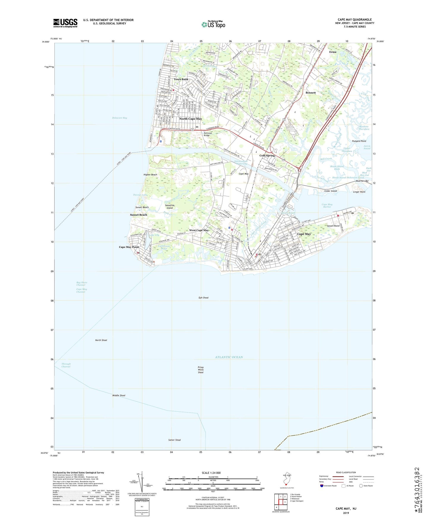
Cape May New Jersey US Topo Map
Couldn't load pickup availability
2019 topographic map quadrangle Cape May in the state of New Jersey. Scale: 1:24000. Based on the newly updated USGS 7.5' US Topo map series, this map is in the following counties: Cape May. The map contains contour data, water features, and other items you are used to seeing on USGS maps, but also has updated roads and other features. This is the next generation of topographic maps. Printed on high-quality waterproof paper with UV fade-resistant inks.
Quads adjacent to this one:
North: Rio Grande
Northeast: Stone Harbor
East: Wildwood
Southwest: Cape Henlopen
Contains the following named places: Bay Shore Channel, Bennett, Bennett Creek, Borough of Cape May Point, Borough of West Cape May, Bradley Run, Buck Landing, Cape Island Creek, Cape Island Marina, Cape May, Cape May Beach Patrol, Cape May Canal, Cape May Channel, Cape May City Elementary School, Cape May County Gas Heliport, Cape May Fire Department, Cape May Fire Department Fire Chief, Cape May Harbor, Cape May Point, Cape May Point Post Office, Cape May Point Volunteer Fire Company, Cape May Police Department, Cape May Post Office, Carl T Mitnick Elementary School, Cedar Creek, Cedar Island, City of Cape May, Coast Guard Base Post Office, Coast Guard Fire Department, Coast Guard Training Center Cape May, Cold Spring, Cold Spring Church, Cox Hall Creek, Daveys Lake, Devils Reach, Dickenson Creek, Eph Shoal, Erma, Erma Census Designated Place, Fishing Creek Church, Ford Creek, Hall Creek, Higbee Beach, Lake Lily, Lido Pond, Lighthouse Pond, Linger Point, Little Cedar Creek, Little Mill Creek, Lower Cape May Regional High School, Lower Township Rescue Squad, Maud H Abrams Elementary School, Mickels Run, Middle Shoal, Mill Creek, Mud Hen Bar, Mud Hen Gut, Naval Air Station Cape May, North Cape May, North Cape May Census Designated Place, North Cape May Post Office, North Jetty Light, North Shoal, Our Lady Star of the Sea School, Petticoat Bridge, Pond Creek, Prissy Wicks Shoal, Punyard Creek, Punyard Point, Richard M Teitelman Middle School, Sandman Consolidated Elementary School, Sassafras Island, Schellenger Creek, Schellenger Landing, Sea View Park, Sewell Point, Skunk Sound, Skunk Sound Ditch, Somer Shoal, South Jetty Light, Southwest Cove, Spicer Creek, Sunset Beach, Tabernacle, Through Channel, Town Bank, Town Bank Volunteer Fire Company, Township of Lower, Upper Thorofare, Warren Creek, Weeks Landing, West Cape May, West Cape May Elementary School, West Cape May Police Department, West Cape May Volunteer Fire Company, ZIP Codes: 08204, 08212