MyTopo
Chester New Jersey US Topo Map
Couldn't load pickup availability
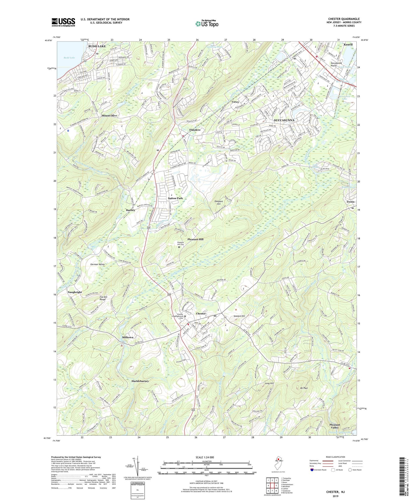
2019 topographic map quadrangle Chester in the state of New Jersey. Scale: 1:24000. Based on the newly updated USGS 7.5' US Topo map series, this map is in the following counties: Morris. The map contains contour data, water features, and other items you are used to seeing on USGS maps, but also has updated roads and other features. This is the next generation of topographic maps. Printed on high-quality waterproof paper with UV fade-resistant inks.
Quads adjacent to this one:
West: Hackettstown
Northwest: Tranquility
North: Stanhope
Northeast: Dover
East: Mendham
Southeast: Bernardsville
South: Gladstone
Southwest: Califon
Contains the following named places: Alstede Farms, Ashley Turkey Farm, Bartley, Bethany Chapel, Black River Middle School, Black River Pond, Black River Wildlife Management Area, Borough of Chester, Bragg Elementary School, Bryant Pond, Budd Lake, Budd Lake Census Designated Place, Budd Lake Post Office, Burnett Brook, Carey, Chester, Chester Borough Police Department, Chester Congregational Cemetery, Chester First Aid Squad, Chester M Stevens Elementary School, Chester Post Office, Chester Township Police Department, Chester Volunteer Fire Company, Conkling Pond, Cooper Grist Mill, Dawsons Brook, Dickerson Elementary School, Drakes Brook, Eisenhower Middle School, Excellence Invalid Coach Services, First Congregational Church, Flanders, Flanders Census Designated Place, Flanders Fire and Rescue Squad, Flanders Mall Shopping Center, Flanders Post Office, Flanders United Methodist Church, Flanders Valley Airport, Flanders Valley County Golf Course, Four Bridges, Franklin Elementary School, German Valley, Hacklebarney, Hacklebarney Farm, Hillside Church, Horseshoe Lake, Ironia, Ironia Post Office, Jayne Valley Farms, Jefferson Elementary School, Kay Environmental Education Center, Kennedy Elementary School, Kessler Institute For Rehabilitation, Kiddie Academy School of Chester, Lake Lillian, Ledgewood Mall Shopping Center, Lincoln-Roosevelt Elementary School, Long Hill, Milltown, Mount Olive, Mount Olive High School, Mount Olive Township Police Department, Mount Paul, Mount Paul Memorial Park, Mountain View Elementary School, Naughright, Pleasant Hill, Pleasant Hill Cemetery, Pleasant Hill Church, Ralston, Ralston Engine Company 1, Riamede Farm, Roxbury High School, Roxbury Mall Shopping Center, Roxbury Township Fire Department Number 1, Serenity Farm, Seward Hill, Suburban Hills School, Succasunna, Succasunna Brook, Succasunna Census Designated Place, Succasunna Plains, Succasunna Post Office, Succasunna-Kenvil Census Designated Place, Sutton Park, Tanners Brook, Tiger Brook Park, Tinc Road Elementary School, Township of Chester, Township of Mount Olive, Tranquility Farm, Triple Lakes, Turkey Brook, West Morris Central High School, Westmont Montessori School, Woodside Farm, ZIP Codes: 07836, 07876, 07930