MyTopo
Hackettstown New Jersey US Topo Map
Couldn't load pickup availability
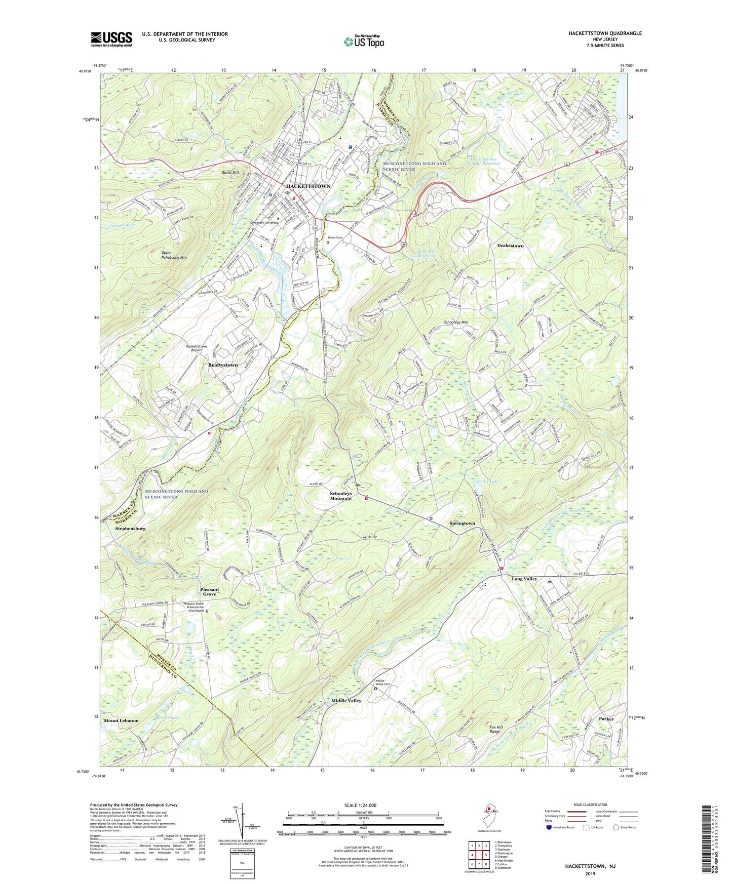
2023 topographic map quadrangle Hackettstown in the state of New Jersey. Scale: 1:24000. Based on the newly updated USGS 7.5' US Topo map series, this map is in the following counties: Morris, Warren, Hunterdon. The map contains contour data, water features, and other items you are used to seeing on USGS maps, but also has updated roads and other features. This is the next generation of topographic maps. Printed on high-quality waterproof paper with UV fade-resistant inks.
Quads adjacent to this one:
West: Washington
Northwest: Blairstown
North: Tranquility
Northeast: Stanhope
East: Chester
Southeast: Gladstone
South: Califon
Southwest: High Bridge
This map covers the same area as the classic USGS quad with code o40074g7.
Contains the following named places: Anderson Hall, Beattystown, Beattystown Census Designated Place, Beisler Lake, Benedict A Cucinella Elementary School, Blue Crest Farms, Brotherton Hall, Bucks Hill, Budd Lake Airport, Budd Lake First Aid Squad, Budd Lake Volunteer Fire Department, Camp Beisler, Camp Beisler Dam, Camp Morris, Camp Washington, Centenary College, Church of the Assumption, Deerfield Farm, Donaldson Farms, Drakestown, Drakestown Methodist Church, Electric Brook, Ferry Building, First Presbyterian Church, Flocktown Kossman Elementary School, Fox Hill Range, George Lake, George Lake Dam, Gruendyke Mill Dam, Hackettstown, Hackettstown Airport, Hackettstown Community Hospital Heliport, Hackettstown Fire Department Moore Street Fire House, Hackettstown First Aid, Hackettstown Fish Hatchery, Hackettstown High School, Hackettstown Medical Center, Hackettstown Middle School, Hackettstown Police Department, Hackettstown Post Office, Hackettstown Storage Reservoir, Hackettstown Storage Reservoir Dam, Hances Brook, Hatchery Brook, Hatchery Hill Elementary School, Highview Farms, Lake George, Long Valley, Long Valley Census Designated Place, Long Valley Fire Company, Long Valley First Aid Squad, Long Valley Middle School, Long Valley Post Office, Long Valley School, Lotte Hall, Mansfield Emergency Medical Services, Middle Valley, Middle Valley Cemetery, Middle Valley School, Mine Brook, Mine Hill Reservoir, Mine Hill Reservoir Dam, Mount Lebanon, Musconetcong Country Club, New York Catholic Summer Camp, Old Farmers Road Elementary School, Parker, Pleasant Grove, Pleasant Grove Presbyterian Church, Pleasant Grove Presbyterian Churchyard, Reeves Hall, Reeves Student Center, Rockport Game Farm, Saint James Episcopal Church, Saint Josephs Church, Saint Mary's Parochial School, Scheller Airport, Schooleys Mountain, Schooleys Mountain Fire Company, Schooleys Mountain Park, Schooleys Mountain Post Office, Schooley's Mountain Presbyterian Church, Scrappy Corner, Seay Administration Building, Smith Hall, Springtown, Stephens State Park, Stephensburg, Stephensburg Brook, Stony Brook, Taylor Memorial Learning Resource Center, Town of Hackettstown, Township of Washington, Trevorrow Hall, Tri - County Volunteer Fire Company, Trinity United Methodist Church, Trout Brook, Union Cemetery, Upper Pohatcong Mountain, Valley Brook Country Day School, Van Winkle Dormitory, Washabaugh Hall, Washington Township Police Department, Willow Grove Elementary School, WRNJ Heliport, WRNJ-AM (Hackettstown), Zion Lutheran Church, ZIP Codes: 07840, 07853, 07870