
MyTopo
Frenchtown New Jersey US Topo Map
Couldn't load pickup availability
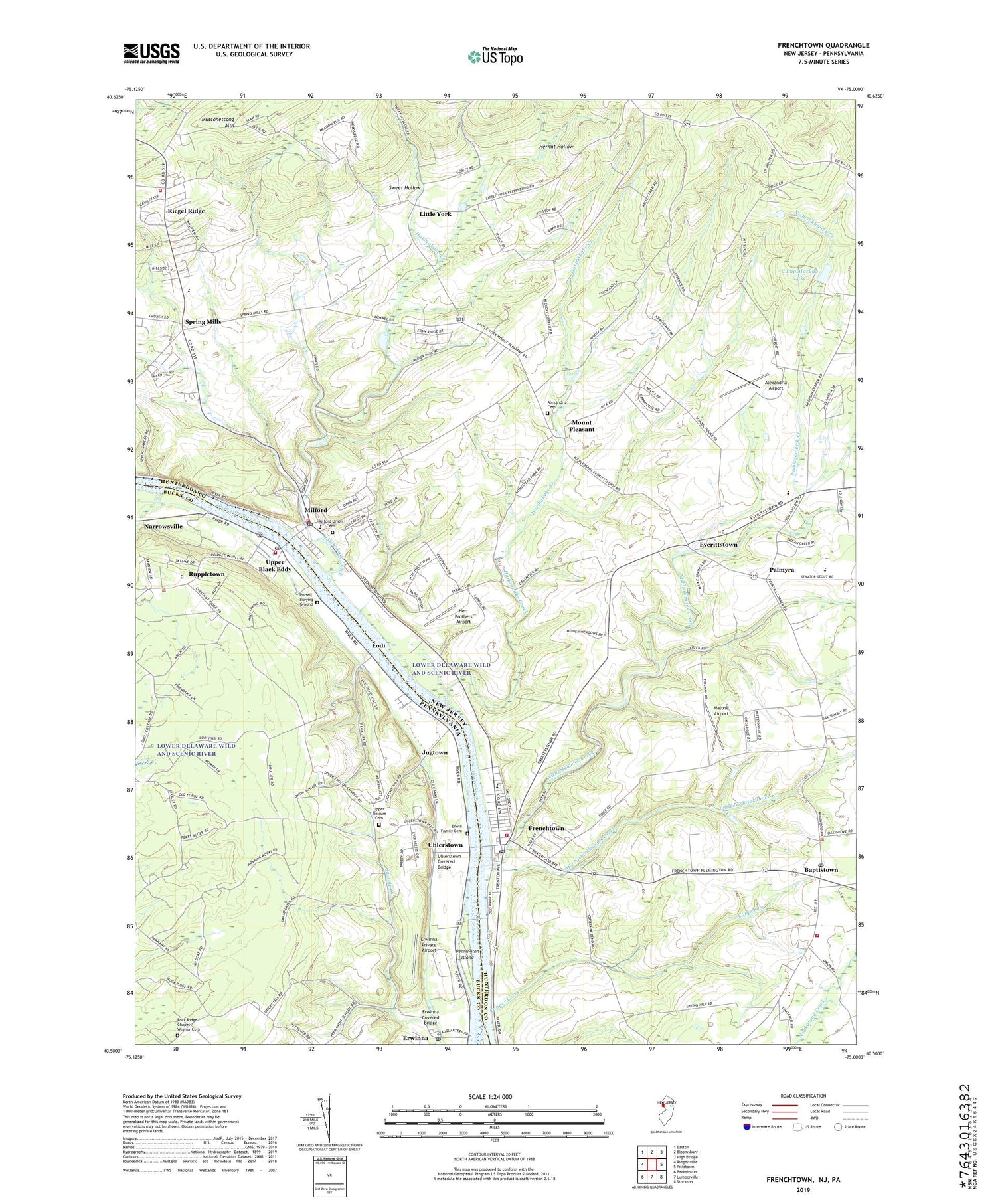
2019 topographic map quadrangle Frenchtown in the states of New Jersey, Pennsylvania. Scale: 1:24000. Based on the newly updated USGS 7.5' US Topo map series, this map is in the following counties: Hunterdon, Bucks. The map contains contour data, water features, and other items you are used to seeing on USGS maps, but also has updated roads and other features. This is the next generation of topographic maps. Printed on high-quality waterproof paper with UV fade-resistant inks.
Quads adjacent to this one:
West: Riegelsville
Northwest: Easton
North: Bloomsbury
Northeast: High Bridge
East: Pittstown
Southeast: Stockton
South: Lumberville
Southwest: Bedminster
Contains the following named places: Alexandria Airport, Alexandria Cemetery, Alexandria Middle School, Baptistown, Baptistown Post Office, Borough of Frenchtown, Borough of Milford, Bridgeton Township Elementary School, Camp Marudy, Camp Marudy Lake, Chestnut Ridge Acres, Chestnut Ridge School, Clay Ridge, Copper Creek, Cumulus Ridge, Delaware Canal State Park, Delaware Valley Regional High School, Edith Ort Thomas Elementary School, Erkes Airport, Erwin Family Cemetery, Erwinna, Erwinna Covered Bridge, Erwinna Post Office, Erwinna Private Airport, Erwinna School, Everbreeze Plateau, Everittstown, Frenchtown, Frenchtown Fire Department, Frenchtown Post Office, Game, Golden Acres Estates, Hakihokake Creek, Harihokake Creek, Hermit Hollow, Herr Brothers Airport, Holland Township Elementary School, Holland Township Middle School, Holland Township Volunteer Fire Company, Jugtown, Kingwood Township Elementary School, Kingwood Township First Aid and Rescue Squad, Kingwood Township Rescue Squad, Kingwood Township Volunteer Fire Department, Lester D Wilson Elementary School, Little Nishisakawick Creek, Little York, Lodi, Malone Airport, Milford, Milford - Holland Rescue Squad, Milford Elementary School, Milford Fire Company, Milford Post Office, Milford Union Cemetery, Mount Pleasant, New Union School, Nishisakawick Creek, Nishisakawick Creek Dam, Palmyra, Pennington Island, Pursell Burying Ground, Riegel Ridge, Rock Ridge Chapel, Rock Ridge Chapel Cemetery, Rock Ridge School, Ruppletown, Spring Mills, Stover House, Sullivan Airport, Swamp Creek, Sweet Hollow, Tinicum County Park, Tinicum Farms Heliport, Township of Alexandria, Township of Bridgeton, Township of Holland, Uhlerstown, Uhlerstown Covered Bridge, Union School, Upper Black Eddy, Upper Black Eddy Fire Company Station 47, Upper Black Eddy Post Office, Upper Tinicum Cemetery, Upper Tinicum Union Church, ZIP Codes: 08825, 08848, 18972


