MyTopo
Bedminster Pennsylvania US Topo Map
Couldn't load pickup availability
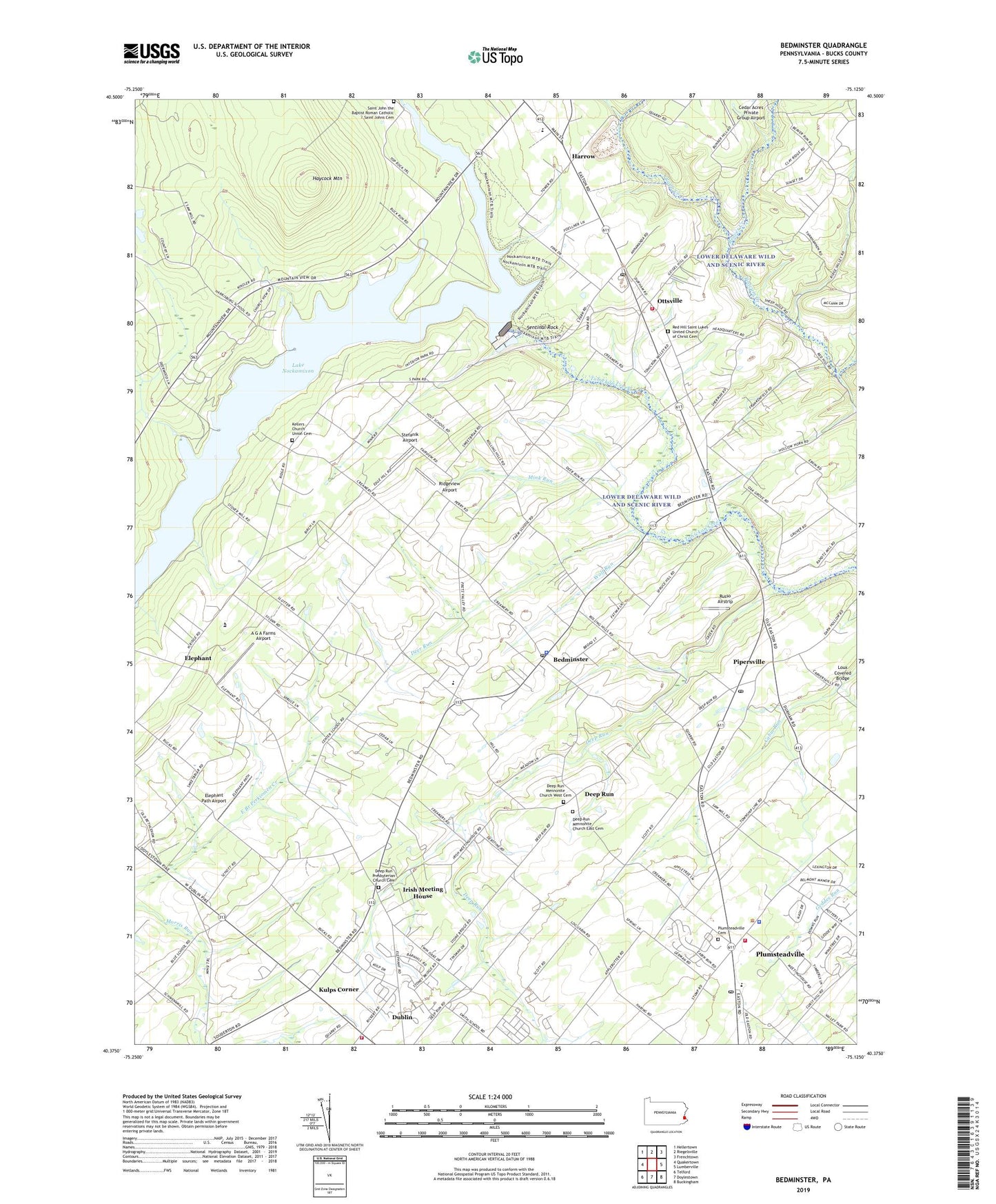
2023 topographic map quadrangle Bedminster in the state of Pennsylvania. Scale: 1:24000. Based on the newly updated USGS 7.5' US Topo map series, this map is in the following counties: Bucks. The map contains contour data, water features, and other items you are used to seeing on USGS maps, but also has updated roads and other features. This is the next generation of topographic maps. Printed on high-quality waterproof paper with UV fade-resistant inks.
Quads adjacent to this one:
West: Quakertown
Northwest: Hellertown
North: Riegelsville
Northeast: Frenchtown
East: Lumberville
Southeast: Buckingham
South: Doylestown
Southwest: Telford
This map covers the same area as the classic USGS quad with code o40075d2.
Contains the following named places: A G A Farms Airport, Beaver Creek, Bedminster, Bedminster Elementary School, Bedminster Post Office, Bedminster Township Municipal Building, Bedminster Township Police Department, Blueberry, Camp Terry Dam, Cedar Acres Private Group Airport, Clay Ridge School, Clearview Estates, Curly Hill Acres, Deep Run, Deep Run East Mennonite Church, Deep Run Mennonite Church East Cemetery, Deep Run Mennonite Church West Cemetery, Deep Run Presbyterian Church, Deep Run Presbyterian Church Cemetery, Deep Run West Mennonite Church, Deer Run, Dublin Acres, Dublin Volunteer Fire Company Station 23, Elephant, Elephant Path Airport, Emergency Spillway of Nockamixon Dam, Grace Gospel Chapel, Harrow, Haycock Mountain, Haycock Township Municipal Building, Irish Meeting House, Kellers Church, Kellers Church Union Cemetery, Kulps Corner, Lake Nockamixon, Loux Covered Bridge, Meadow Lane Homes, Mink Run, Nesbes Estates, Nockamixon State Park Dam, Ottsville, Ottsville Post Office, Ottsville Volunteer Fire Company Station 49, Peace Lutheran Church, Pipersville, Pipersville Library, Pipersville Post Office, Plummstead Township Police Department, Plumstead Christian School, Plumstead Township Municipal Building, Plumstead Township Police Department, Plumsteadville, Plumsteadville Cemetery, Plumsteadville Census Designated Place, Plumsteadville Industrial Park, Plumsteadville Post Office, Plumsteadville School, Plumsteadville Shopping Center, Plumsteadville Volunteer Fire Company Station 24, Point Pleasant - Plumsteadville Emergency Medical Services, Ranots Mill Dam, Rapp Creek, Red Hill Saint Lukes United Church of Christ, Red Hill Saint Lukes United Church of Christ Cemetery, Ridgeview Airport, Russo Airstrip, Saint John the Baptist Catholic Church, Saint John the Baptist Catholic School, Saint John the Baptist Roman Catholic Cemetery, Saint Luke Lutheran Church, Saint Matthews Evangelical Lutheran Church, Sentinal Rock, Smith School, Solomons United Church of Christ, Spruce Hill Acres, State Game Lands Number 157, Stefanik Airport, Sterling Close, Stewarts Village Shopping Center, Stonebridge, Talley Estates, Tohickon Mill Dam, Township of Bedminster, Traugers Park, Upper Bucks County Area Vocational Technical School, Valley Park School, Wolf Run, ZIP Codes: 18917, 18942, 18944