MyTopo
Point Pleasant New Jersey US Topo Map
Couldn't load pickup availability
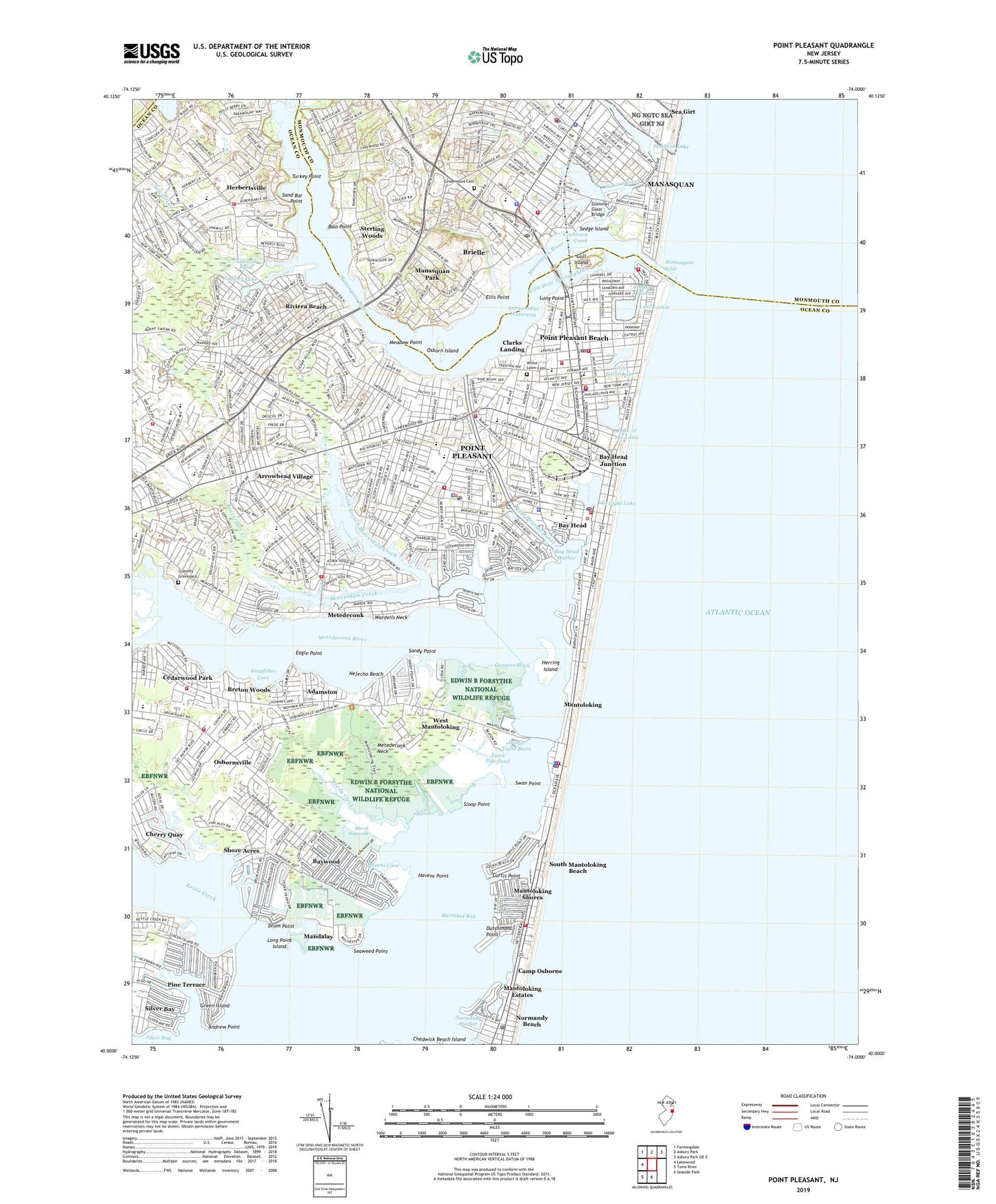
2023 topographic map quadrangle Point Pleasant in the state of New Jersey. Scale: 1:24000. Based on the newly updated USGS 7.5' US Topo map series, this map is in the following counties: Ocean, Monmouth. The map contains contour data, water features, and other items you are used to seeing on USGS maps, but also has updated roads and other features. This is the next generation of topographic maps. Printed on high-quality waterproof paper with UV fade-resistant inks.
Quads adjacent to this one:
West: Lakewood
Northwest: Farmingdale
North: Asbury Park
Northeast: Asbury Park OE E
South: Seaside Park
Southwest: Toms River
This map covers the same area as the classic USGS quad with code o40074a1.
Contains the following named places: Adamston, Adamston County Airport, All Saints Episcopal Church, Andrew Point, Arrowhead Village, Bass Point, Bay Head, Bay Head Elementary School, Bay Head Fire Company 1, Bay Head Harbor, Bay Head Junction, Bay Head Police Department, Bay Head Post Office, Bay Head Reading Center, Baywood, Beaver Hill Farm, Beaverdam Creek, Blodgett Landing, Borough of Bay Head, Borough of Brielle, Borough of Brielle Fire Department, Borough of Manasquan, Borough of Mantoloking, Borough of Point Pleasant, Borough of Point Pleasant Beach, Breton Woods, Brick Township Bureau of Fire Safety, Brick Township Fire Department Breton Woods Fire Company Station 21, Brick Township Fire Department Fire Training Center, Brick Township Fire Department Laurelton Fire Company 1 Substation 23 - 1, Brick Township Fire Department Laurelton Fire Company 1 Substation 23 - 2, Brick Township Fire Department Pioneer Hose Fire Company Station 22 - 1, Brielle, Brielle Circle, Brielle Elementary School, Brielle Fire Inspector, Brielle First Aid Squad, Brielle Police Department, Brielle Post Office, Camp Chadbourne, Camp Osborne, Cedar Bridge Branch, Central United Methodist Church, Cherry Quay, Clarks Landing, Coast Guard Station Manasquan Beach, Community First Aid Squad, Cooks Creek, Crabtown Creek, Curtis Point, Debbies Creek, Deep Creek, Drum Point, Dutchmans Point, Eagle Point, Ellis Point, Faith Bible Presbyterian Church, First Assembly of God Church, First Baptist Church, Fisherman Cove Conservation Area, Fresh Pond, G Harold Antrim Elementary School, Glimmer Glass Bridge, Godfrey Lake, Good Shepherd Lutheran Church, Gravelly Graveyard, Green Island, Greenwood Cemetery, Gull Island, Gunners Ditch, Harvey Memorial Methodist Church, Havens Cove, Havens Point, Hebertsville Elementary School, Herbertsville, Herbertsville Fire Company 1 Station 24, Herbertsville First Aid Squad, Herring Island, Jones Tide Pond, Judas Creek, Kettle Creek, Kingdom Hall of Jehovahs Witnesses, Kingfisher Cove, Lake Louise, Lake of the Lilies, Laurelton School, Laurelton Yacht Basin, Little Silver Lake, Long Island Cove, Long Point, Long Point Island, Manasquan Fire District 1 Manasquan Hook and Ladder 1, Manasquan Inlet, Manasquan Park, Manasquan Police Department, Manasquan Post Office, Manasquan River, Manasquan River Golf Club, Mandalay, Mantoloking, Mantoloking Borough Fire Company 1 Station 35, Mantoloking Estates, Mantoloking Police Department, Mantoloking Post Office, Mantoloking Shores, Marsh Baywood, Meadow Point, Memorial Middle School, Metedeconk, Metedeconk Neck, Metedeconk River, Middle Sedge Island Heliport, Midstreams Elementary School, Midstreams Park, Nejecho Beach, Nellie F Bennett Elementary School, New Jersey National Guard Sea Girt Unit, Normandy Beach, Normandy Beach Post Office, Normandy Harbor, North Branch Beaverdam Creek, Northern Water Pollution Control Facility, Ocean Fire Company 1 Station 42, Ocean Road Elementary School, Osborn Island, Osbornsville, Osbornsville Baptist Church, Osbornsville Elementary School, Pine Terrace, Pioneer Hose Fire Company 1 Station 22, Point Borough First Aid Squad, Point Pleasant, Point Pleasant Beach, Point Pleasant Beach Fire Company 2, Point Pleasant Beach Fire Department, Point Pleasant Beach First Aid and Emergency Squad, Point Pleasant Beach High School, Point Pleasant Beach Police Department, Point Pleasant Beach Post Office, Point Pleasant Boro Post Office, Point Pleasant Canal, Point Pleasant Fire Department Station 75, Point Pleasant Fire Department Station 75 - 1, Point Pleasant Golf Club, Point Pleasant High School, Point Pleasant Hospital, Point Pleasant Police Department, Point Pleasant Presbyterian Church, Point Pleasant State Marina, Reedy Creek, Riviera Beach, Riviera Beach Yacht Club, Roberts Swamp Brook, Saint Denis Elementary School, Saint Dominic's Roman Catholic Church, Saint Dominics School, Saint Mary's by the Sea Episcopal Church, Saint Paul Church, Saint Paul's Christian School, Saint Peter's Church, Saint Peter's School, Saint Simon by the Sea Church, Sand Bar Point, Sandy Point, Sarah Switzers Rest Camp, Sawmill Creek, Sawmill Pond, Seaweed Point, Sedge Island, Shore Acres, Silver Bay, Sloop Point, South Mantoloking Beach, Sterling Woods, Stockton Lake, Swamp Cove, Swan Point, Swan Point State Natural Area, Temple Beth Or, The Glimmerglass, Tide Creek, Township of Brick, Turkey Point, Twilight Lake, United States Coast Guard Manasquan Inlet Station, Veteran's Memorial Elementary School, Veteran's Memorial Middle School, Visitation Roman Catholic Church, Wall Community First Aid Squad, Wardells Neck, Watson Creek, West Mantoloking, West Osbornsville, West Point Pleasant, Whisman, White Lawn Cemetery, Wills Hole Thoroughfare, Winding River Village, Windward Beach Park, Winter Yacht Basin, ZIP Codes: 08723, 08724, 08730, 08736, 08738, 08742