MyTopo
Isleta New Mexico US Topo Map
Couldn't load pickup availability
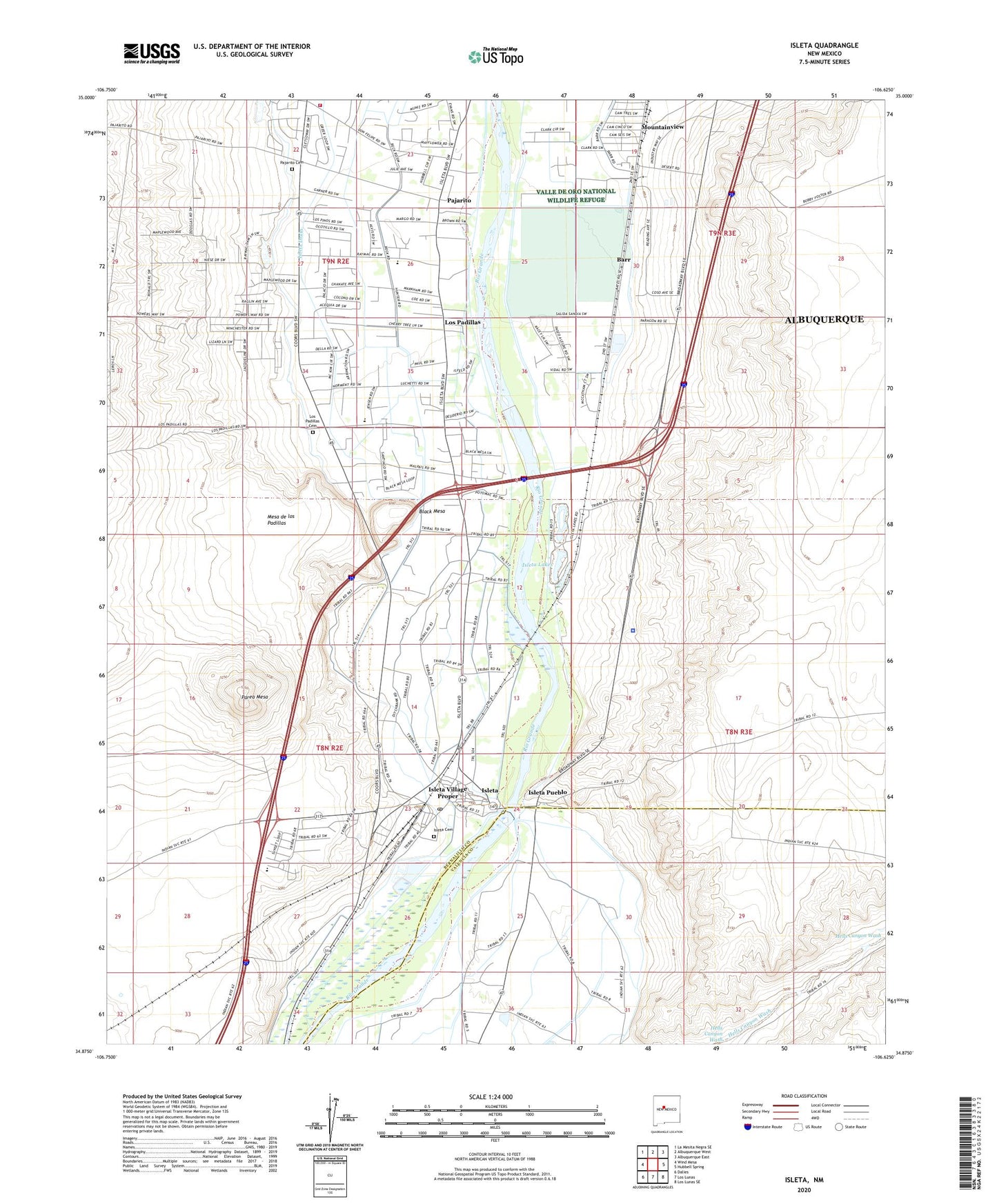
2020 topographic map quadrangle Isleta in the state of New Mexico. Scale: 1:24000. Based on the newly updated USGS 7.5' US Topo map series, this map is in the following counties: Bernalillo, Valencia. The map contains contour data, water features, and other items you are used to seeing on USGS maps, but also has updated roads and other features. This is the next generation of topographic maps. Printed on high-quality waterproof paper with UV fade-resistant inks.
Quads adjacent to this one:
West: Wind Mesa
Northwest: La Mesita Negra SE
North: Albuquerque West
Northeast: Albuquerque East
East: Hubbell Spring
Southeast: Los Lunas SE
South: Los Lunas
Southwest: Dalies
Contains the following named places: 10001 Water Well, 10002 Water Well, 10010 Water Well, 10011 Water Well, 10012 Water Well, 10013 Water Well, 10062 Water Well, 10063 Water Well, 87022, Barr, Barr Interior Drain, Bernalillo County Fire and Rescue Station 4, Black Mesa, Butte Lateral, Chava Water Well, Egg Farm Test Water Well, Hubbell House Historic Site, Indian Lateral, Isleta, Isleta Casino and Resort, Isleta Cemetery, Isleta Census Designated Place, Isleta Diversion Dam, Isleta Drain, Isleta Emergency Medical Services, Isleta Indian Drain, Isleta Indian Lateral, Isleta Lakes, Isleta Lateral, Isleta Police Department, Isleta Post Office, Isleta Pueblo, Isleta Pueblo Division, Isleta Pueblo Grant, Isleta Pueblo Library Resource Center, Isleta Riverside Drain, Isleta Tribal Police Department, KMBA-AM (Los Ranchos de Albuquerque), Los Padillas, Los Padillas Acequia, Los Padillas Cemetery, Los Padillas Drain, Los Padillas Elementary School, Los Padillas Historical Marker, Mc Elroy Pit, Mesa de los Padillas, Mountainview, Mountainview Mission, Padillas Post Office, Pajarito, Pajarito Cemetery, Pajarito Post Office, Parea Mesa, Polk Middle School, Pueblo of Isleta Historical Marker, Putman Drain, Saint Augustine Church, Sandhills Lateral, SBLF-2 Water Well, State Pit, Test Hole 1 water Well, Test Hole 2 Water Well, Test Hole 3 Water Well, Test Hole 4-77 Water Well, Test Hole 5-77 Water Well, Test Hole 6-77 Water Well, Test Hole 7-77 Water Well, Test Hole 8-77 Water Well, United States Bureau of Reclamation 2 Water Well, Upper Chical Acequia, Upper Chical Lateral, Upper Cosique Acequia, Valle de Oro National Wildlife Refuge