MyTopo
Clinton New York US Topo Map
Couldn't load pickup availability
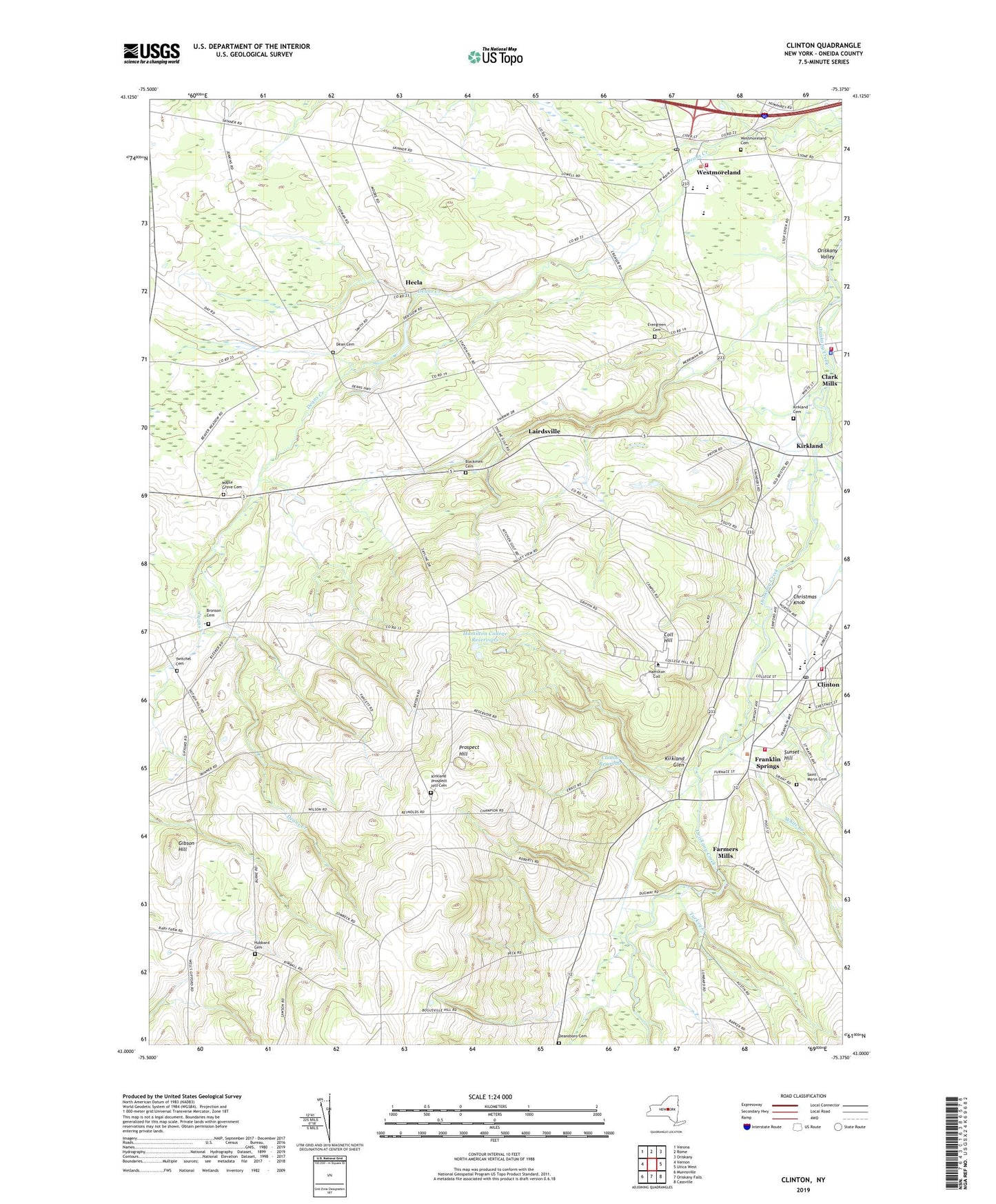
2023 topographic map quadrangle Clinton in the state of New York. Scale: 1:24000. Based on the newly updated USGS 7.5' US Topo map series, this map is in the following counties: Oneida. The map contains contour data, water features, and other items you are used to seeing on USGS maps, but also has updated roads and other features. This is the next generation of topographic maps. Printed on high-quality waterproof paper with UV fade-resistant inks.
Quads adjacent to this one:
West: Vernon
Northwest: Verona
North: Rome
Northeast: Oriskany
East: Utica West
Southeast: Cassville
South: Oriskany Falls
Southwest: Munnsville
This map covers the same area as the classic USGS quad with code o43075a4.
Contains the following named places: Afro-Latin Cultural Center, Alumni Gymnasium, Anderson-Connell Alumni Center, Annunciation Church, Azel Backus House, Babbitt Hall, Beinecke Student Activities Village, Benedict Hall, Birdies Eagles and Ducks Golf Course, Blackmen Cemetery, Bristol Campus Center, Bundy Dining Hall, Bundy Hall, Buttrick Hall, Campus Road Athletic Field, Carnegie Hall, Central Oneida County Volunteer Ambulance Corps, Charlean And Wayland Blood Fitness And Dance Center, Christian A Johnson Hall, Christmas Knob, Clark Mills, Clark Mills Census Designated Place, Clark Mills Sewer District Wastewater Treatment Plant, Clark Mills Volunteer Fire Department, Clinton, Clinton Arena, Clinton Elementary School, Clinton Fire Department, Clinton High School, Clinton Post Office, Clinton Reservoir, College Hill, Couper Hall, Daniel Burke Library, Dean Cemetery, Deansboro Cemetery, Dunham Hall, Eells House, Elihu Root House, Emerson Hall, Evergreen Cemetery, Fairway Farm, Farmers Mills, Ferguson House, Ferguson Intramural Fields, Ferry Building, Franklin Springs, Gibson Hill, Glen House, Gray Tennis Courts, Hamilton College, Hamilton College Census Designated Place, Hamilton College Chapel, Hamilton College Golf Course, Hamilton College Reservoirs, Hamilton College Science Center, Hecla, Hinman Farms, Hubbard Cemetery, Keehn Hall, Kirkland, Kirkland Cemetery, Kirkland Cottage, Kirkland Glen, Kirkland Hall, Kirkland Prospect Hill Cemetery, Kirkland Town Library, Kirner-Johnson Building, Lairdsville, Lairdsville United Methodist Church, Lairdsville Volunteer Fire Department, List Art Center, Little Squash Center, Love Field, Major Hall, Maple Grove Cemetery, Margaret Bundy Scott Field House, Mason Field, Maurice Horowitch Career Center, McEwen Dining Hall, McIntosh Hall, Milbank Hall, Minor Hall, Minor Theater, Molly Root House, North Hall, Oriskany Creek Farm, Philip Spencer House, Prospect Hill, Resurrection Assembly of God Church, Rogers Estate, Root Farmhouse, Root Hall, Royce Baseball Field, Rudd Health Center, Sage Rink, Saint James Episcopal Church, Saint Marys Cemetery, Saint Mary's School, Saunders House, Schambach Center For Music And The Performing Arts, School Number 2, Siuda House, Skenandoa Club of Clinton, Skenandoa House, Soper Hall of Commons, South Hall, Steuben Field, Stone Presbyterian Church, Sunset Hill, The Observatory, Town of Kirkland, Town of Westmoreland, Turkey Creek, Twitchel Cemetery, Vernon Center Cemetery, Victory Assembly Church, Village of Clinton, Wallace Johnson House, Wells Corner, Wertimer House, Westmoreland, Westmoreland Cemetery, Westmoreland Census Designated Place, Westmoreland Fire Department, Westmoreland Golf Club, Westmoreland Post Office, Westmoreland Toll Plaza, Westmoreland United Methodist Church, WFRG-FM (Rome), WFXV-TV (Utica), WHCL-FM (Clinton), White Creek, William M Bristol Junior Swimming Pool, WKGW-FM (Utica), Woollcott House, WUUU-FM (Rome), ZIP Codes: 13323, 13341, 13490