MyTopo
Moriches New York US Topo Map
Couldn't load pickup availability
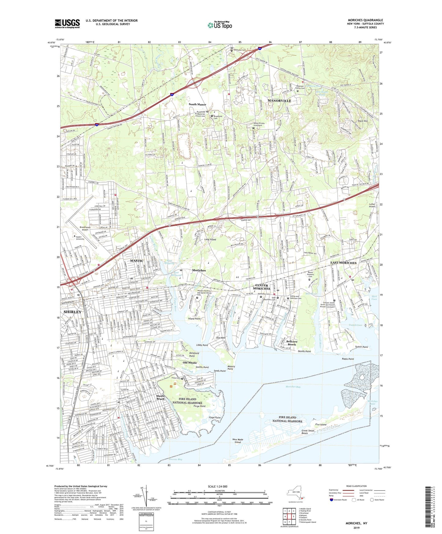
2019 topographic map quadrangle Moriches in the state of New York. Scale: 1:24000. Based on the newly updated USGS 7.5' US Topo map series, this map is in the following counties: Suffolk. The map contains contour data, water features, and other items you are used to seeing on USGS maps, but also has updated roads and other features. This is the next generation of topographic maps. Printed on high-quality waterproof paper with UV fade-resistant inks.
Quads adjacent to this one:
West: Bellport
Northwest: Middle Island
North: Wading River
Northeast: Riverhead
East: Eastport
South: Pattersquash Island
Southwest: Howells Point
Contains the following named places: Areskonk Creek, Assembly of God of Center Moriches, Bayview Baptist Church, Bayview Hospital, Bells African Methodist Episcopal Church, Bellview Beach, Bishop and Robinson Cemetery, Brookfield Cemetery, Brookfield Presbyterian Church, Brookfield Presbyterian Church Cemetery, Brookhaven Airport, Brookhaven Fire Department Station 1, Cedar Lodge Nursing Home, Center Moriches, Center Moriches Census Designated Place, Center Moriches Fire Station, Center Moriches High School, Center Moriches Methodist Church, Center Moriches Post Office, Center Moriches Public Library, Center Moriches Shopping Center, Center Moriches Station, Christ Full Gospel Church, Christ Lutheran Church, Church in the Wildwood, Clayton Huey Elementary School, Colonel Josiah Smith and Howell Private Graveyard, Cranberry Pond, Davids Point, Delafield Point, Dowling College Brookhaven Campus, East Millpond, East Moriches, East Moriches Census Designated Place, East Moriches Community Ambulance Service, East Moriches Fire Department, East Moriches Post Office, East Moriches School, East Moriches Station, East Moriches United Methodist Church, Ely Creek, First Church of God in Christ, First Presbyterian Church, Floyd Cemetery, Floyd Point, Forge Point, Forge River, Grace Lutheran Church, Greenwood Village, Home Creek, Hot Water Pond, Iglesia Fuente de Jacob, Island Point, Kingdom Hall of Jehovah's Witnesses, Lawrence Creek, Libby Point, Long Island Game Farm, Lons Creek, Lufker Airport, Manorville, Manorville Census Designated Place, Manorville Community Ambulance Service, Manorville Community Church, Manorville Fire Department Headquarters, Manorville Fire Department Station 1, Manorville Fire Department Station 2, Manorville Gap Filler Annex, Manorville Post Office, Marks Canal, Mastic, Mastic Beach, Mastic Beach Census Designated Place, Mastic Beach Fire Department, Mastic Beach Post Office, Mastic Census Designated Place, Mastic Fire Station, Mastic Post Office, Mastic Station, Mastic Volunteer Ambulance Service, Mastics - Moriches - Shirley Community Library, Masury Point, Methodist Cemetery, Mill Pond, Moriches, Moriches Census Designated Place, Moriches Elementary School, Moriches Inlet, Moriches Post Office, Moriches Yacht Club, Mount Pleasant Cemetery, Mud Creek, Narrow Bay, Nathaniel Woodhull Elementary School, New Hope Revival Church, New Made Island, New York National Speedway, Old Mastic, Old Neck, Old Neck Creek, Old Ship of Zion United Holy Church, Olde Beachfern Cemetery, Orchard Neck Creek, Pattersquash Creek, Pine Hills Country Club, Poospatuck Creek, Poospatuck Reservation, Presbyterian Church of the Moriches, Radio Point, Robinson Family Cemetery, Rock Hill, Rock Hill Country Club, Saint Andrew Episcopal Church, Saint Andrews School, Saint Angelas Convent, Saint John The Evangelist Roman Catholic Church, Saint John the Evangelist School, Saint John's Episcopal Church, Saint Jude's Hall, Saint Jude's Roman Catholic Church, Saint Peter and Paul Roman Catholic Church, Sands Point, Second Neck Creek, Senix Creek, Shirley, Shirley Census Designated Place, Shirley Community Ambulance, Shirley Drive-In, Shirley Post Office, Smith Point County Park, Smiths Point, South Bay Bible Fellowship Church, South Manor, South Street School, Terrell River, The Lagoon, The Links at Shirley, Tuthill Cove, Tuthill Point, Upton Station, Village of Mastic Beach, West Millpond, William Floyd Elementary School, William Floyd Estate, William Floyd High School, William Hawkins and Daniel Downs Cemetery, Wines Private Graveyard, WPBX-FM (Southampton), WRCN-FM (Riverhead), ZIP Codes: 11934, 11940, 11949, 11950, 11951, 11955