MyTopo
Niskayuna New York US Topo Map
Couldn't load pickup availability
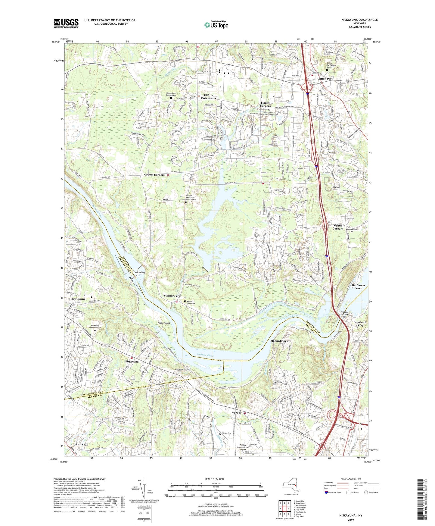
2023 topographic map quadrangle Niskayuna in the state of New York. Scale: 1:24000. Based on the newly updated USGS 7.5' US Topo map series, this map is in the following counties: Saratoga, Albany, Schenectady. The map contains contour data, water features, and other items you are used to seeing on USGS maps, but also has updated roads and other features. This is the next generation of topographic maps. Printed on high-quality waterproof paper with UV fade-resistant inks.
Quads adjacent to this one:
West: Schenectady
Northwest: Burnt Hills
North: Round Lake
Northeast: Mechanicville
East: Troy North
Southeast: Troy South
South: Albany
Southwest: Voorheesville
This map covers the same area as the classic USGS quad with code o42073g7.
Contains the following named places: Albany County Jail, Amity Dutch Reformed Church, Arongen Elementary School, Beacon Pointe Memory Care Assisted Living Center, Bens Greenhouse, Birchwood Elementary School, Boght Hills School, Bowman Orchards, Burns Whitney Park, Central Square Mobile Home Park, Christ Community Reformed Church, Church of Christ, Clare Bridge of Niskayuna Assisted Living Center, Clifton Gardens Census Designated Place, Clifton Knolls Executive Golf Course, Clifton Knolls-Mill Creek Census Designated Place, Clifton Park, Clifton Park - Halfmoon Public Library, Clifton Park and Halfmoon Emergency Corps, Clifton Park Baptist Cemetery, Clifton Park Baptist Church, Clifton Park Center, Clifton Park Community Church, Clifton Park Fire Department, Clifton Park Post Office, Clifton Park United Methodist Church, Clifton Park Village Cemetery, Colonie Reservoir, Delphus Kill, Devoe's Rainbow Orchards, Diamond Reef Yacht Club, Dunsbach Ferry, Edison Club Golf Course, Flagler Corners, Forts Ferry School, General Electric Research and Development Center Heliport, Goat Island, Grays Corners, Groom Church, Groom Corners, Grooms Methodist Church Cemetery, Guptill Industrial Park, Halfmoon Beach, Halfmoon Post Office, Harvest Church, Hicks Fruit Farm, Idyllwood Orchard, Iroquois Middle School, Jonesville Fire District Station 2, Kaiser Industrial Park, King Crest Farm, King of Kings Lutheran Church, Klamsteam Marina, Knolls Atomic Power Lab Ambulance, Latham Drive-In, Latham Outlet Village Shopping Center, Lawrence Tree Farm, Lisha Kill, Lishakill Park, Lock Number 7, Marotta Health and Wellness Church, Martindale Mobile Home Park, Mill Road Acres Golf Course, Millious Dutch Reformed Church Cemetery, Mohawk River Country Club, Mohawk View, Most Holy Redeemer Cemetery, New Loudon Center Shopping Center, New York State Game Management Area, Niska Island, Niskayuna, Niskayuna Fire Company District Number 2, Niskayuna Reformed Church, Northstar Church, Northway Bible Chapel, Northway Fellowship Church, Okte Elementary School, Oronacah Farm, Plaza Seven Shopping Center, Prince of Peace Lutheran Church, Riverview Orchards, Rosendale School, Saint Ambrose School, Saint Edward's Church, Saint Georges Church, Saint George's Episcopal Church, Saint Leo Church, Saratoga Drive-In, School Number 4, School Number 6, Schuyler Ridge Nursing Home, Shakers Creek, Shenendehowa High School, Shenendehowa United Methodist Church, Sheperd's Hey Farm, Sicker Cemetery, Springbrook Mobile Home Park, Stony Creek, Thaddeus Kosciusko Bridge, Town of Clifton Park, Town of Niskayuna, Veeder Elementary School, Verdoy, Verdoy Volunteer Fire Department, Vischer Ferry, Vischer Ferry Cemetery, Vischer Ferry Fire District Station 1, Vischer Ferry Fire District Station 2, Vischer Ferry Fire District Station 3, West Crescent Cemetery, Whitney Estates, WTRY Radio Tower (Ticonderoga), WTRY-AM (Troy), ZIP Codes: 12065, 12110, 12148, 12309