MyTopo
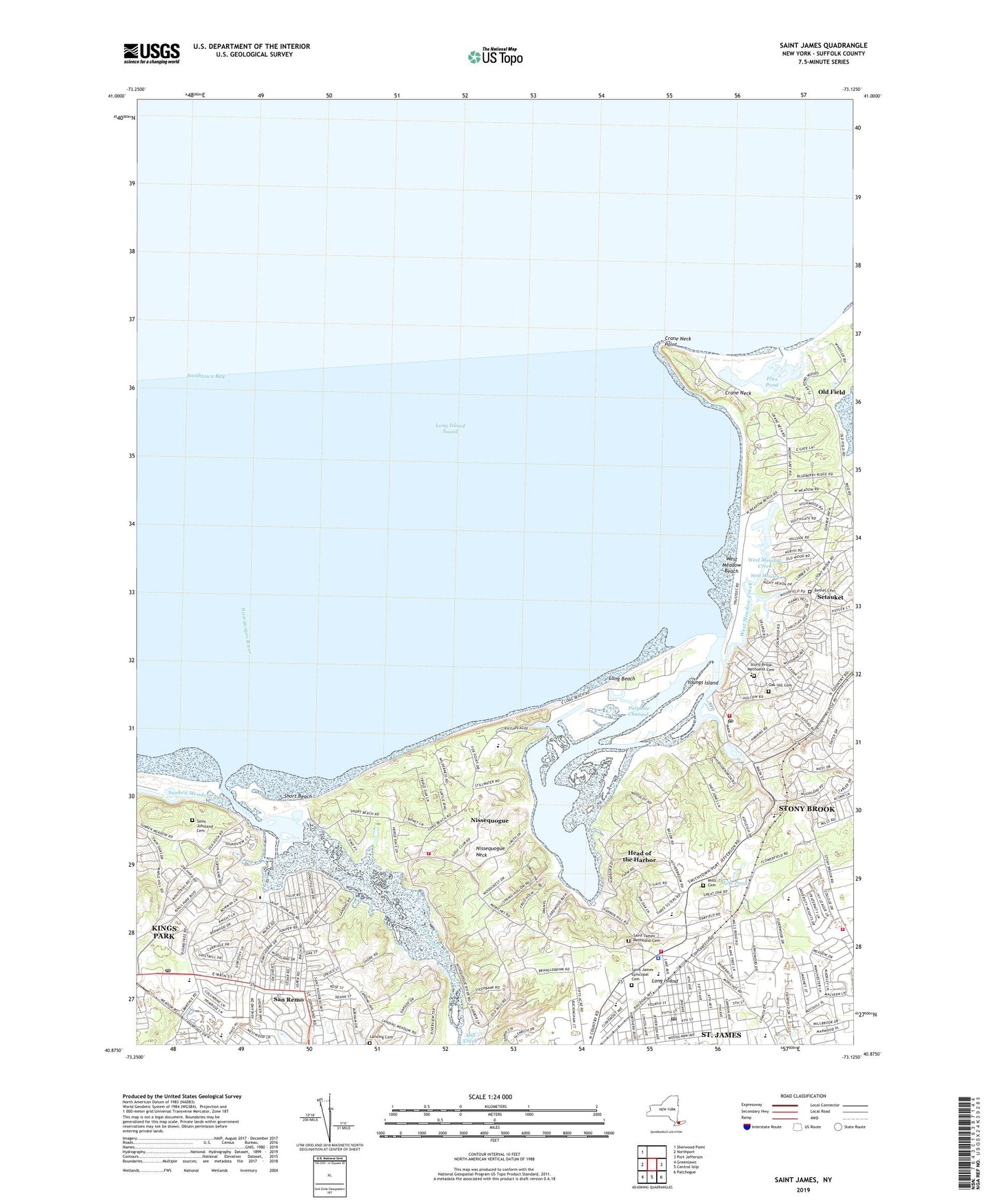
Saint James New York US Topo Map
Couldn't load pickup availability
2023 topographic map quadrangle Saint James in the state of New York. Scale: 1:24000. Based on the newly updated USGS 7.5' US Topo map series, this map is in the following counties: Suffolk. The map contains contour data, water features, and other items you are used to seeing on USGS maps, but also has updated roads and other features. This is the next generation of topographic maps. Printed on high-quality waterproof paper with UV fade-resistant inks.
Quads adjacent to this one:
West: Northport
Northwest: Sherwood Point
East: Port Jefferson
Southeast: Patchogue
South: Central Islip
Southwest: Greenlawn
This map covers the same area as the classic USGS quad with code o40073h2.
Contains the following named places: All Souls Episcopal Church, Bethel Cemetery, Christian Avenue School, Community School, Crane Neck, Crane Neck Point, Flax Pond, Flowerfield Airport, Gaynor Park, Harbor Country Day School, Harrison Pond Park, Head of the Harbor, Head of the Harbor Village Police Department, Kings Park Census Designated Place, Kings Park High School, Kings Park Post Office, Kings Park Psychiatric Center, Knox School, Landing Cemetery, Little Africa Town Park, Long Beach, Long Beach Town Park, Long Island Museum of American Art History and Carriages, Maryville Convent, Mill Creek, Mills Cemetery, Mills Pond, Mills Pond Elementary School, Nissequogue, Nissequogue Fire Department, Nissequogue Golf Course, Nissequogue Neck, Nissequogue Point Beach Club, Nissequogue River, Nissequogue School, North Country School, North Shore Montessori School, Oak Hill Cemetery, Old Field, Old Field Club, Olson Memorial Town Park, Parkview Elementary School, Porpoise Channel, Saint Anthonys High School, Saint James, Saint James Census Designated Place, Saint James Elementary School, Saint James Episcopal Cemetery, Saint James Episcopal Church, Saint James Fire Department, Saint James Healthcare Center, Saint James Lutheran Church, Saint James Methodist Cemetery, Saint James Post Office, Saint James Station, Saint Johnland Cemetery, Saint Johnland Childrens Home, Saint Johnland Nursing Center, Saints Phillips and James School, San Remo, San Remo Elementary School, Short Beach, Smithtown Bay Yacht Club, Smithtown Landing Country Club, Stony Brook, Stony Brook Census Designated Place, Stony Brook Community Methodist Church, Stony Brook Fire Department, Stony Brook Fire Department Station 2, Stony Brook Girls School, Stony Brook Harbor, Stony Brook Methodist Cemetery, Stony Brook Post Office, Stony Brook School, Stony Brook Station, Stony Brook Volunteer Ambulance Corps, Stony Brook Yacht Club, Sunken Meadow Creek, The Mallows, Town of Smithtown, Village of Head of the Harbor, Village of Nissequogue, Village of Old Field, W S Mount Elementary School, West Meadow, West Meadow Beach, West Meadow Beach Historic District, West Meadow Creek, West Meadow Wetlands Reserve, Woodcrest, Youngs Island, ZIP Codes: 11754, 11780, 11790