MyTopo
Sloatsburg New York US Topo Map
Couldn't load pickup availability
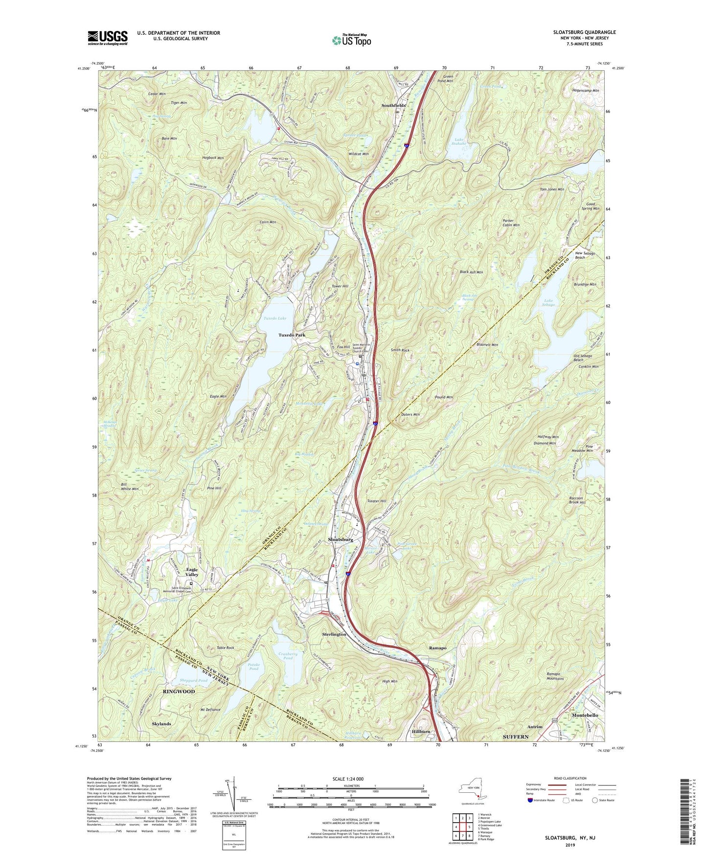
2023 topographic map quadrangle Sloatsburg in the states of New York, New Jersey. Scale: 1:24000. Based on the newly updated USGS 7.5' US Topo map series, this map is in the following counties: Orange, Rockland, Passaic, Bergen. The map contains contour data, water features, and other items you are used to seeing on USGS maps, but also has updated roads and other features. This is the next generation of topographic maps. Printed on high-quality waterproof paper with UV fade-resistant inks.
Quads adjacent to this one:
West: Greenwood Lake
Northwest: Warwick
North: Monroe
Northeast: Popolopen Lake
East: Thiells
Southeast: Park Ridge
South: Ramsey
Southwest: Wanaque
This map covers the same area as the classic USGS quad with code o41074b2.
Contains the following named places: Bare Mountain, Bill White Mountain, Black Ash Mountain, Black Ash Swamp, Blauvelt Mountain, Bog Meadow, Brundige Mountain, Cairn Mountain, Cedar Mountain, Clinton Woods, Cranberry Pond, Dater Mountain County Park, Daters Mountain, Delaney Swamp, Diamond Creek, Diamond Mountain, Eagle Lake, Eagle Mountain, Eagle Valley, Eagle Valley Volunteer Fire Company, Flag Swamp, Fox Hill, George F Baker High School, George Grant Mason Elementary School, Good Spring Mountain, Green Pond, Green Pond Mountain, Halfway Mountain, High Mountain, Hillburn Reservoir, Hogback Mountain, Indian Kill, Kakiat Trail, Lake Sebago, Lake Skemonto, Lake Stahahe, Laurel Ridge, Little Long Pond, Long Swamp, Louis E Euvard Memorial Field, McKeags Meadow, Memorial Hospital, Metro-North Tuxedo Station, Mirror Lake, Mountain Lake, New Sebago Beach, Nungin Sunwon Buddhist Temple, Old Sebago Beach, Parker Cabin Hollow, Parker Cabin Mountain, Pine Grove Lake, Pine Hill, Pine Meadow Brook, Pine Meadow Lake, Pine Meadow Mountain, Pine Meadow Trail, Potake Pond, Pound Mountain, Raccoon Brook Hill, Ramapo, Ramapo Rest Area, Ramapo-Dunderberg Trail, Saint Elizabeth Memorial Chapel Cemetery, Saint Joan of Arc Catholic Church, Saint Joseph Adult Care Home, Saint Mary's Episcopal Church, Saint Marys In Tuxedo Church Cemetery, Saint Marys Villa Academy, Shelton College, Sheppard Pond, Skylands, Sleater Hill, Sloatsburg, Sloatsburg Elementary School, Sloatsburg Municipal Building, Sloatsburg Post Office, Sloatsburg Public Library, Sloatsburg Rest Area, Sloatsburg United Methodist Church, Sloatsburg Volunteer Community Ambulance Corps, Sloatsburg Volunteer Fire Department, Smith Rock, Southfields, Southfields Post Office, Spring Brook, Spruce Pond, Spruce Pond Camp, Spruce Swamp, Sterling Forest Volunteer Fire Company Number 2, Sterlington, Stony Brook, Summit Brook, Table Rock, Tiger Mountain, Tom Jones Mountain, Torne Brook, Tower Hill, Town of Tuxedo, Tuxedo, Tuxedo Lake, Tuxedo Memorial Park, Tuxedo Park, Tuxedo Park Fire Department, Tuxedo Park Golf Course, Tuxedo Park Library, Tuxedo Park Post Office, Tuxedo Park School, Tuxedo Square Shopping Center, Village of Hillburn, Village of Sloatsburg, Village of Tuxedo, Village of Tuxedo Park, Warwick Brook, We-Wah Lake, Whitney Brook, Wildcat Mountain, ZIP Codes: 10931, 10974, 10987