MyTopo
Elk Park North Carolina US Topo Map
Couldn't load pickup availability
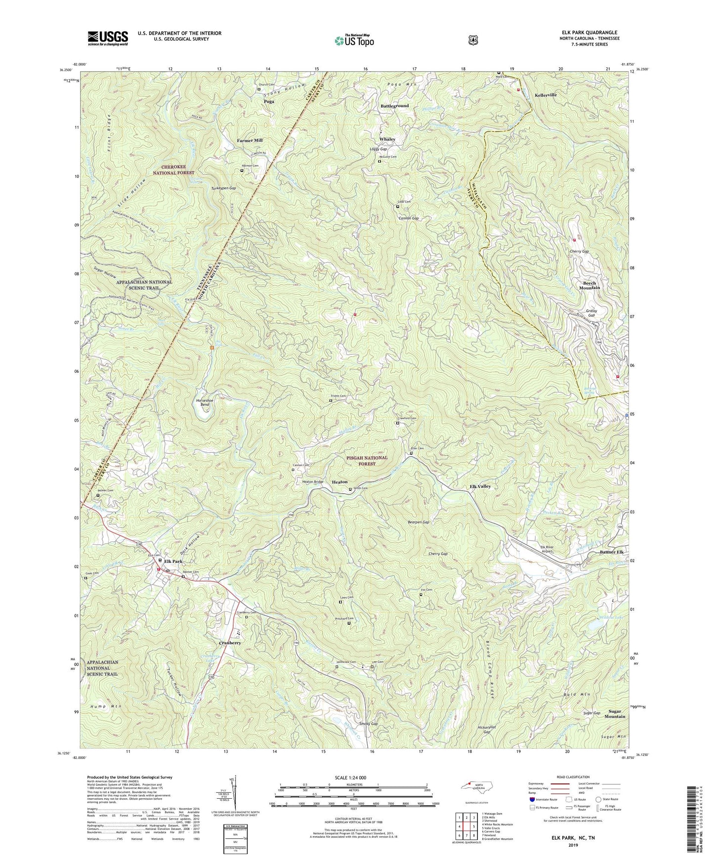
2019 topographic map quadrangle Elk Park in the states of North Carolina, Tennessee. Scale: 1:24000. Based on the newly updated USGS 7.5' US Topo map series, this map is in the following counties: Avery, Carter, Watauga. The map contains contour data, water features, and other items you are used to seeing on USGS maps, but also has updated roads and other features. This is the next generation of topographic maps. Printed on high-quality waterproof paper with UV fade-resistant inks.
Quads adjacent to this one:
West: White Rocks Mountain
Northwest: Watauga Dam
North: Elk Mills
Northeast: Sherwood
East: Valle Crucis
Southeast: Grandfather Mountain
South: Newland
Southwest: Carvers Gap
Contains the following named places: Arbor Dale Church, Avery County Emergency Medical Services Banner Elk Station, Avery County Emergency Rescue Squad Ambulance Service, Bald Mountain, Banner Cemetery, Battleground, Bear Branch, Bearpen Gap, Beech Creek Church, Beech Creek Mountain Church, Beech Creek School, Beech Mountain, Beech Mountain Church, Beech Mountain Police Department, Beech Mountain School, Beech Mountain Volunteer Fire Department - Station 2, Beech Mountain Volunteer Fire Department Station 1, Big Black Pine Rough, Big Falls, Big Pine Mountain, Big Ridge, Blevins Creek, Blevins Creek Chapel, Blevins Ridge, Blood Camp Ridge, Buck Mountain, Buck Mountain School, Buckeye Creek, Buckeye Spring, Cannon Branch, Cannon Cemetery, Cannon Gap, Cherokee Wildlife Management Area, Cherry Gap, Chestnut Ridge, Clingman Mine Branch, Cook Cemetery, Cooper Branch, Cranberry, Cranberry Cemetery, Cranberry Creek, Cranberry Dam, Cranberry High School, Cranberry Lake, Cranberry Mines, Crawford Cemetery, Curtis Creek, Curtis Creek Church, Dark Hollow, Dark Ridge, Don Nelan Appalachian Trail Shelter, Double Knobs, Egg Knob, Elk Falls Point of Interest, Elk Park, Elk Park Elementary School, Elk Park Post Office, Elk Park Volunteer Fire Department, Elk Ridge, Elk River Airport, Elk Valley, Eller Cemetery, Ellis Cemetery, Fall Creek, Fall Creek Church, Fall Creek Volunteer Fire Department Station 1, Fall Creek Volunteer Fire Department Station 2, Farmer Mill, Flint Ridge, Forked Ridge, Fox Cemetery, Friendship Church, Grandfather Home for Children, Grassy Gap, Grassy Gap Creek, Greenbrier Creek, Harmon Cemetery, Heaton, Heaton Bridge, Hemlock Hill, Hickorynut Gap, High Point Church, Holston Camp, Holtsclaw Cemetery, Horney Branch, Horse Ridge, Horseshoe Bend, Jones Branch, Jones Falls, Kellersville School, Kellerville, Laurel Fork School, Laws Cemetery, Lee Branch, Lee Cemetery, Lees-McRae College, Leroy Creek, Little Black Pine Rough, Little Elk Church, Little Elk Creek, Little Hump Mountain, Little Pine Mountain, Loggy Gap, Lost Ridge, McGuire Cemetery, Mill Creek, Miller Branch, Nowhere Branch, Nowhere Ridge, Palmer Cemetery, Peavine Branch, Phillips Branch, Piney Grove Church, Piney Grove Church of Christ Cemetery, Pinnacle Ridge, Pinnacles of the Beech, Pisgah Game Lands, Pleasant Valley Church, Poga, Poga Mountain, Poga School, Pond Creek, Pritchard Cemetery, Puckett Branch, Ramp Branch, Red Rock Ridge, Round Knob, Skalley Branch, Skalley Knob, Slide Hollow, Smith Cemetery, Smoky Gap, Smoky Mountain, State Line Branch, Stony Creek, Stony Hollow, Sugar Gap, Sugar Hollow, Taylor Chapel, Town of Beech Mountain, Town of Elk Park, Township of Banner Elk, Township of Beech Mountain, Township of Cranberry, Township of Elk Park, Township of Heaton, Trivett Branch, Trivett Cemetery, Tucker Hollow, Turkeypen Gap, Twisting Falls, Union Church, Valley Haven Church, Ward Cemetery, Ward Mountain, Whaley, Whitehead Creek, Wildcat Creek, Wildcat Lake, ZIP Code: 28622