MyTopo
White Rocks Mountain Tennessee US Topo Map
Couldn't load pickup availability
Also explore the White Rocks Mountain Forest Service Topo of this same quad for updated USFS data
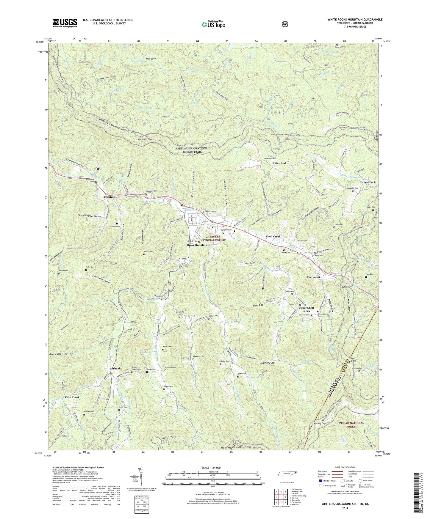
2022 topographic map quadrangle White Rocks Mountain in the states of Tennessee, North Carolina. Scale: 1:24000. Based on the newly updated USGS 7.5' US Topo map series, this map is in the following counties: Carter, Avery. The map contains contour data, water features, and other items you are used to seeing on USGS maps, but also has updated roads and other features. This is the next generation of topographic maps. Printed on high-quality waterproof paper with UV fade-resistant inks.
Quads adjacent to this one:
West: Iron Mountain Gap
Northwest: Elizabethton
North: Watauga Dam
Northeast: Elk Mills
East: Elk Park
Southeast: Newland
South: Carvers Gap
Southwest: Bakersville
This map covers the same area as the classic USGS quad with code o36082b1.
Contains the following named places: Barnett Cemetery, Bear Branch, Bear Ridge, Bearwallow Branch, Bearwallow Hollow, Big Bear Cove Ridge, Big Nance Ridge, Big Ridge, Birchfield Cemetery, Bitter End, Bitter End School, Blackwell Cemetery, Bluegrass Hollow, Bowling Branch, Bowling Chapel, Bradley Gap, Buck Cemetery, Buck Creek, Bunton Branch, Burbank, Burbank Freewill Baptist Church, Burbank School, Calhoun Cemetery, Camp Ten Branch, Campbell Pen Knob, Caraway Cemetery, Cherry Flats Ridge, Cloudland Elementary School, Cloudland High School, Commissioner District 2, Cook Branch, Cordell Cemetery, Cove Creek, Cove Creek School, Crabtree, Crabtree Church, Dave Miller Hollow, Depot Hollow, Dolan Hollow, Doll Branch, Doll Flats, Duck Branch, Ellis Hollow, Elm Hollow, Evergreen, Evergreen Freewill Baptist Church, Firescald Branch, Five Poplar Branch, Fork Ridge, Freeman Cemetery, Frog Level, George Creek, Gibbs Cemetery, Gouge Cemetery, Grays Chapel, Greer Cemetery, Hampton Cemetery, Hampton Creek, Hampton Creek Ridge, Hampton Creek School, Hamptons Forge, Harris Hollow, Harrison Street Hollow, Hays Branch, Heaton Creek, Heaton Creek Ridge, Heaton Creek School, Heupscup Knobs, High Point Church, Hodge Hollow, Houston Ridge, Hump Mountain, Isaacs Cemetery, Johnson Cemetery, Johnson Hollow, Jones Cemetery, Julian Cemetery, Knight Cemetery, Laban, Lacy Trap Branch, Lacy Trap Ridge, Laurel Branch, Laurel Fork, Laurel Fork Trail, Laurel Fork Wildlife Management Area, Left Prong Hampton Creek, Leonard Branch, Little Cove Creek, Little Laurel Fork, Little Roaring Creek, Lower Heaton Creek Church, Lower Shell Creek Christian Church, Magill Memorial Church, Markland Cemetery, McClain Cemetery, McKinney Gap, Middle Branch, Miller Cemetery, Miller Hollow, Mine Hollow, Moreland Branch, Moreland Cemetery, Moreland Gap, Morgan Branch, Morgan Branch Chapel, Morgan Hollow, Morlands Mill, Northeast Correctional Complex Carter County Annex, Oaks Cemetery, Odemville, Odom Trout Lake, Odom Trout Lake Dam, Panther Branch, Perkins Cemetery, Perkins Hollow, Perry Branch, Perry Cemetery, Peters Cemetery, Piney Mountain, Richardson Cemetery, Roan Mountain, Roan Mountain Census Designated Place, Roan Mountain Division, Roan Mountain Post Office, Roan Mountain Volunteer Fire Department, Roaring Creek, Saint Johns Church, Shell Cemetery, Shell Creek, Shell Creek School, Shelly Hollow, Shoemaker Branch, Smith Cemetery, Squawberry, Stout Cemetery, Sugar Hollow, Sugar Hollow Church, Sugar Hollow Creek, Sugar Hollow School, Sunrise View Church, Toms Branch, Upper Heaton Creek Church, Upper Shell Creek, Upper Shell Creek Christian Church, Upper Shell Creek School, Vance Gap, Vanderpool Ridge, Wagner Branch, Webb Hollow, White Rock Lookout Tower, White Rocks Mountain, Whiteoak Ridge, Wilder Mine Hollow, Wilson Cemetery, Winter Hollow, Winters Cemetery, Yellow Mountain Gap, ZIP Codes: 37658, 37687