MyTopo
Northeast Goldsboro North Carolina US Topo Map
Couldn't load pickup availability
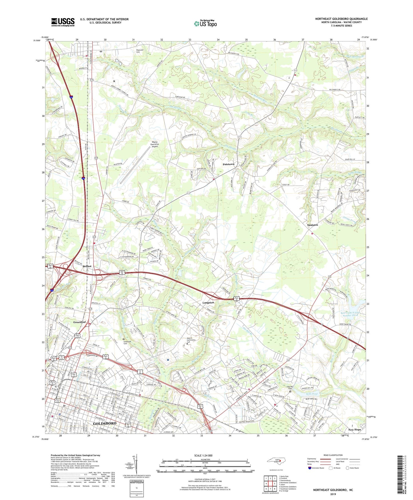
2019 topographic map quadrangle Northeast Goldsboro in the state of North Carolina. Scale: 1:24000. Based on the newly updated USGS 7.5' US Topo map series, this map is in the following counties: Wayne. The map contains contour data, water features, and other items you are used to seeing on USGS maps, but also has updated roads and other features. This is the next generation of topographic maps. Printed on high-quality waterproof paper with UV fade-resistant inks.
Quads adjacent to this one:
West: Northwest Goldsboro
Northwest: Kenly East
North: Fremont
Northeast: Stantonsburg
East: Jason
Southeast: La Grange
South: Southeast Goldsboro
Southwest: Southwest Goldsboro
Contains the following named places: Adamsville Church, Alpha and Omega Christian Center, Alterra Sterling House of Goldsboro, Anointed Vision Christian Church, Antioch Church, Antioch Volunteer Fire Department - Wayne County Station 7, Bayleaf, Bear Creek W/S Lake Number Four, Bear Creek W/S Lake Number Three, Bearcreek, Belfast, Belfast Elementary School, Belfast School, Belfast Volunteer Fire Department - Watne County Station 11, Berkeley Mall, Best Grove Church, Bethel Church, Big Daddys Airport, Billy Branch, Bread of Heaven United Holy Church, Brian Center Health and Rehabilitation of Goldsboro, Central Heights, Central Heights Free Will Church, Central School, City of Goldsboro, Coley Acres, Colonial Acres, Community Developmental School, Dennis Best Lots, Eastern Wayne Elementary School, Eastern Wayne High School, Eastern Wayne Junior High School, Eastgate Shopping Center, Edgewood School, Fairview Park, First Pentecostal Holiness Church, First Presbyterian Church, Forest Hill, Free Chapel, Freedom Baptist Church, Goldsboro, Goldsboro Fire Department Station 1, Goldsboro Fire Department Station 2, Goldsboro Fire Department Station 3, Goldsboro Fire Department Station 5, Goldsboro High School, Goldsboro Junior High School, Goldsboro Plaza, Goldsboro Police Department, Goldsboro Post Office, Goldsboro Seventh Day Adventist Church, Goldsboro Volunteer Rescue and Emergency Medical Services, Good Shepherd Lutheran Church, Gospel Tabernacle Church, Grace Baptist Church, Granny Branch, Greenleaf, Greenleaf Cemetery, Greenleaf School, H Weil Dam, Handley Acres, Herman Park, Howell Branch, Jefferson United Methodist Church, John Oliver Center, Kingdom Hall of Jehovahs Witnesses, Kitty Askins Hospice Center, Langston, Liberty Church, Little Nahunta Church, Long Branch, Millers Crossing, Mimosa Park, Mission of Love Church, Moccasin Run, Mount Carmel Church, Mount Zion Church, Musgrave Crossroads, Nahunta Church, New Greenleaf Church of Christ, New Hope, New Hope Census Designated Place, New Hope Church, New Hope Road Church of God, New Life Baptist Church, New Spirit Church, Nichols Shopping Center, North Drive School, North Plaza, Northfields, Northview Church, Oak Forest Road Church of Christ, Oakridge Church of God of Prophecy, Old Mill Branch, Old Mill Cemetery, Parker Chapel, Patetown, Patetown Church of God, Patetown Volunteer Fire Department - Wayne County Station 10, Peacock Park, Pentecostal Christian Assembly, Pentecostal Holy Church, Philadelphia Community Church, Pikeville, Pikeville - Pleasant Grove Volunteer Fire Department, Pikeville Cemetery, Pikeville Post Office, Pine Haven, Pinemont, Pineview Church, Pinewood, Pinewood Presbyterian Church, Pinewood Volunteer Fire Department, Pleasant View, Quail Park, Ravenwood, Reedy Branch, Ridgewood, Saint Marys Catholic Church, Saint Marys School, Saint Paul Church, Saint Stephen Missionary Baptist Church, Salem Acres, Salem Church, Saulston, Saulston United Methodist Church, Saulston Volunteer Fire Department, Shiloh Church, Smith Mill Run, Spring Hill, Stoney Creek, Stoney Manor Mobile Home Park, Stoney Run, Stony Creek Church, Sunrise Shopping Center, Teakwood, The Church of Jesus Christ of Latter Day Saints, The Pines at Goldsboro, Thomas Bass Dam, Thompsons Church, Tiffany Gardens, Town of Pikeville, Township of Goldsboro, Township of Pikeville, Township of Stoney Creek, True Holiness Assembly Church, Victory Free Will Baptist Church, Vinson Manor, Walnut Street School, Wayne Community College, Wayne County Day School, Wayne County Emergency Medical Services Station 6, Wayne County Mental Health Center, Wayne County Public Library - Main Branch, Wayne County Public Library - Pikeville Branch, Wayne County Sheriff's Office, Wayne Executive Jetport, Wayne Memorial Hospital, Wayne Plaza, White Oak Church, White Oak Grove Church, Wills Pond, Winbon Acres, Woods Chapel, Woods Grove Church, Woodside Mobile Home Park, ZIP Code: 27863