MyTopo
Southeast Goldsboro North Carolina US Topo Map
Couldn't load pickup availability
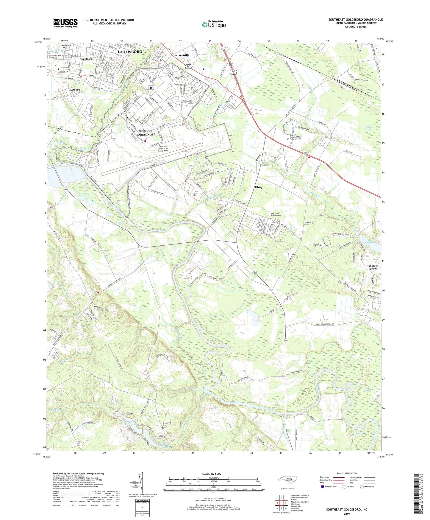
2022 topographic map quadrangle Southeast Goldsboro in the state of North Carolina. Scale: 1:24000. Based on the newly updated USGS 7.5' US Topo map series, this map is in the following counties: Wayne. The map contains contour data, water features, and other items you are used to seeing on USGS maps, but also has updated roads and other features. This is the next generation of topographic maps. Printed on high-quality waterproof paper with UV fade-resistant inks.
Quads adjacent to this one:
West: Southwest Goldsboro
Northwest: Northwest Goldsboro
North: Northeast Goldsboro
Northeast: Jason
East: La Grange
Southeast: Seven Springs
South: Williams
Southwest: Mount Olive
This map covers the same area as the classic USGS quad with code o35077c8.
Contains the following named places: 4th Medical Group - Seymour Johnson Air Force Base Thomas Koritz Hospital, Adamsville, Adamsville Church, Adamsville Church of God, Airboro, Anderwood Estates, Arrington Volunteer Fire Department, Ashley Plaza, Atkinson Chapel, Berkeley Post Office, Berkeley Village, Branch Church, Brogden Chapel, Burnt Mill Branch, Cabin Branch, Camp Carver, Carver Heights Elementary School, Casey Chapel, Caseys Trailer Lodge, Community Church of Christ, Daniels Memorial Church, Deerwood, Dillard Elementary School, Donaldson Mobile Home Park, East End School, Eastern Carolina State Veterans Cemetery, Elroy, Elroy Census Designated Place, Elroy Volunteer Fire Department - Station 1, Emmaus Church, Faith Alliance Church, Faith United Holy Church, Fellows Branch, First African Baptist Church, Goldsboro Chapel Free Will Church, Goldsboro Fire Department Station 4, Goldsboro Wesleyan Church, Grace Mission, Green Meadows, Greenfield Memorial Park Cemetery, Greenwood School, Guiding Star Holy Church, Hickory Hills Mobile Home Park, Hillcrest Farm, Holly Green Church, Holy Temple, Irongate, Johnson Chapel, Korean Presbyterian Church, Madison Avenue Church, Meadow Lane School, Middle School North, Middle School South, Millers Chapel, Mina Weil Park, New Hope Friends Cemetery, New Hope Friends Church, New Saint John African Methodist Episcopal Church, New Stoney Hill Church, Oak Forest, Old Smoky Church, Peace Church, Pine Level Branch, Princeton Deliverance Center, Saint Andrews Episcopal Church, Saint John Church, Saint Luke Church, Sandy Springs, Seymour Johnson Air Force Base, Seymour Johnson Air Force Base Fire Department, Seymour Johnson Homes, Sheridan Forest, Sleepy Creek, Sleepy Creek Lake Lower, Sleepy Creek Lake Lower Dam, Sleepy Creek Lake Upper, Sleepy Creek Lake Upper Dam, Southridge Mobile Home Park, Stoney Creek, Stoney Creek Mobile Home Park, Township of New Hope, Trinity Church, Walker Memorial Church, Walker Mill Run, Walnut Creek, Walnut Pocosin, Webtown, Willow Dale Cemetery, Woodshire Mobile Estates, ZIP Codes: 27531, 27534