MyTopo
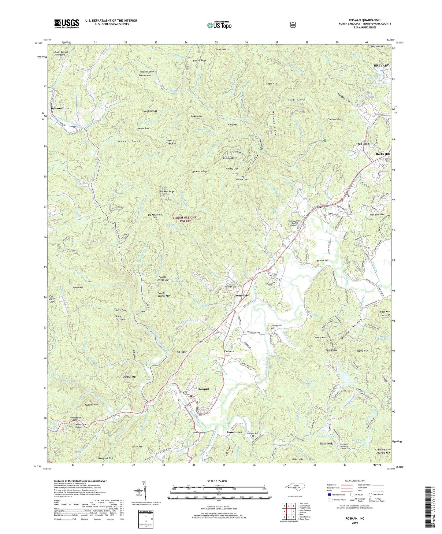
Rosman North Carolina US Topo Map
Couldn't load pickup availability
2019 topographic map quadrangle Rosman in the state of North Carolina. Scale: 1:24000. Based on the newly updated USGS 7.5' US Topo map series, this map is in the following counties: Transylvania. The map contains contour data, water features, and other items you are used to seeing on USGS maps, but also has updated roads and other features. This is the next generation of topographic maps. Printed on high-quality waterproof paper with UV fade-resistant inks.
Quads adjacent to this one:
West: Lake Toxaway
Northwest: Sam Knob
North: Shining Rock
Northeast: Pisgah Forest
East: Brevard
Southeast: Table Rock
Southwest: Reid
Contains the following named places: Adams Branch, Aiken Mill Creek, Aiken Mountain, Arthur Lake, Ash Cove, Balsam Grove, Balsam Grove Post Office, Balsam Grove Volunteer Fire Department, Barberry Heights, Bart Branch, Beasley Branch, Big Bearwallow Creek, Big Mountain Branch, Big Mountain Gap, Big Mountain Ridge, Big Ridge, Bird Rock Falls, Blue Ridge Branch, Boring Creek, Brackens Creek, Brevard Music Center Lake, Browns Mill Creek, Brushy Knob, Brushy Ridge, Brushy Ridge Branch, Buffeys Branch, Bunker Hill, Bynum Branch, Calvert, Camp Cherryfield, Camp Illahee, Cantrell Creek, Carson Creek, Catheys Creek, Catheys Creek Baptist Church Cemetery, Catheys Creek Church, Catheys Creek Estates, Catheys Creek Falls, Cedar Rock Creek, Charles Creek, Cherryfield, Cherryfield Creek, Chestnut Gap, Connestee Fire Rescue Station 92, Cove Hollow, Crawford Mountain, Crow Branch, Cycleham Gap, Daves Cove, Daves Rock, Deep Woods Dam, Deep Woods Lake, Diamond Creek, Double Springs Gap, Double Springs Mountain, Dunns Creek, East Fork, East Fork French Broad River, East Fork Methodist Church Cemetery, Flat Creek, Ford Lake, Ford Lake Dam, Frozen Creek, Gads Cove, Galloway Creek, Gaylors Branch, Gerren Creek, Gillespie Cemetery, Glady Branch, Glady Fork, Grassy Gap, Graveyard Hill, Henry Mountain, Hickory Mountain Branch, High Loaf Mountain, Illahee Hills, Indian Camp Branch, Indian Creek, Jason Branch, Joshua Branch, Kagle Branch, Kagle Mountain, Kaiser Lake, Kelley Branch, Kelley Mountain, Keystone Camp, King Mountain, Kuykendall Creek, Kuykendall Recreation Site, Lake Wanteska, Lake Wanteska Dam, Lamance Creek, Laurel Branch, Laurel Falls, Laurel Falls Lake, Laurel Lake, Laurel Lake Dam, Limekiln Branch, Little Bearwallow Creek, Little Egypt, Little Tarkiln Branch, Long Branch, Long Hollow, Long Hollow Gap, Lora Young Dam, Lora Young Lake, Low Notch Gap, Lower Creek, Mason Creek, Matheys Branch, McFarland Lake, Middle Creek, Middle Fork French Broad River, Mill Creek, Mitchums Lake, Morgan Hill, Morgan Mill Creek, Mount Moriah Church, Mountain Tea Branch, North Fork French Broad River, Panther Mountain, Patterson Creek, Paxton Creek, Peter Weaver Creek, Pine Grove Gap, Piney Mountain, Piney Woods, Powelltown, Quebec Mountain, Rainbow Lake, Revels Mountain, Revels Prong, Rich Cove, Rocky Hill, Rocky Mountain, Rosman, Rosman Elementary School, Rosman Fire and Rescue Station 6, Rosman High School, Rosman Post Office, Rover Church, Sawmill Creek, Schoolpath Branch, Sega Lake, Selica, Shearin Dam, Shearin Pond, Shoal Creek, Shoal Creek Church, Southern Mountain, Spanish Oak Branch, Spice Cove, Spice Cove Mountain, Stone Mountain, Tarkiln Branch, Tarkiln Mountain, Three Forks Mountain, Town of Rosman, Township of Catheys Creek, Transylvania County, Transylvania School Camp, Tucker Creek, Upper Creek, Walker Mountain, Walnut Cove, Walnut Gap, Walnut Hollow, West Fork French Broad River, Whetstone Gap, Whetstone Ridge, Whitmire Cemetery, Wilson Mill Creek, Wolfpen Cove, Woodruff Branch, Woodruff Mountain, Zion Church, ZIP Code: 28712