MyTopo
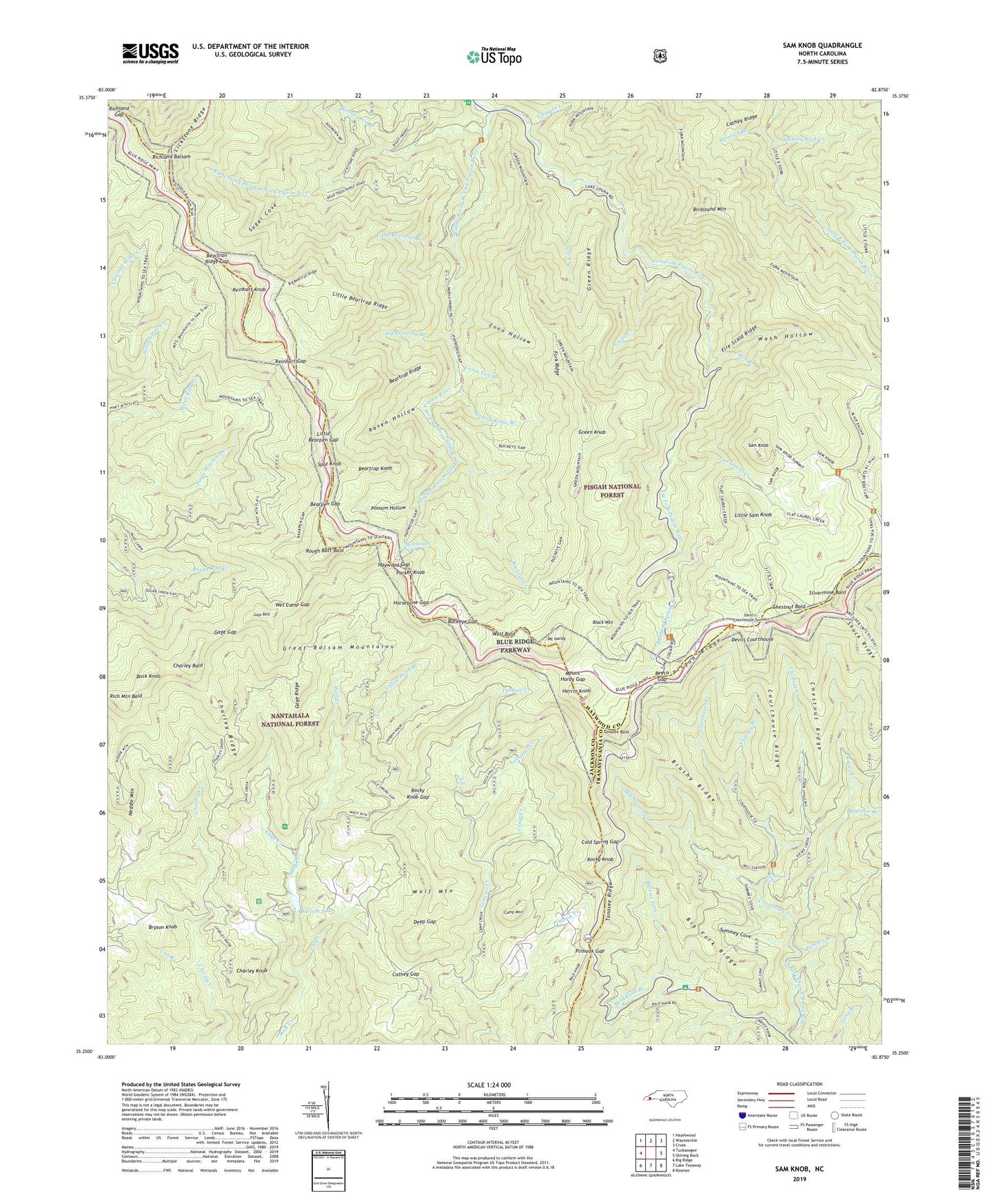
Sam Knob North Carolina US Topo Map
Couldn't load pickup availability
Also explore the Sam Knob Forest Service Topo of this same quad for updated USFS data
2022 topographic map quadrangle Sam Knob in the state of North Carolina. Scale: 1:24000. Based on the newly updated USGS 7.5' US Topo map series, this map is in the following counties: Haywood, Jackson, Transylvania. The map contains contour data, water features, and other items you are used to seeing on USGS maps, but also has updated roads and other features. This is the next generation of topographic maps. Printed on high-quality waterproof paper with UV fade-resistant inks.
Quads adjacent to this one:
West: Tuckasegee
Northwest: Hazelwood
North: Waynesville
Northeast: Cruso
East: Shining Rock
Southeast: Rosman
South: Lake Toxaway
Southwest: Big Ridge
This map covers the same area as the classic USGS quad with code o35082c8.
Contains the following named places: Bald Knob Branch, Balsam Lake, Bearpen Branch, Bearpen Gap, Beartrail Ridge Gap, Beartrap Knob, Beartrap Ridge, Beech Gap, Beetree Fork, Big Beartrail Ridge, Big Beartrap Branch, Big Fork Ridge, Birdstand Mountain, Black Mountain, Boomer Inn Branch, Brushy Ridge, Bryson Knob, Bubbling Spring Branch, Buck Knob, Buckeye Creek, Buckeye Gap, Camp Creek, Camp Mountain, Camp Two Branch, Cathey Gap, Cathey Ridge, Charley Bald, Charley Creek School, Charley Knob, Charley Ridge, Chestnut Bald, Chestnut Creek, Chestnut Ridge, Coalney Branch, Cold Creek, Cold Spring Gap, Coon Hollow, Courthouse Creek, Courthouse Falls, Courthouse Ridge, Cub Branch, Deep Gap, Devils Courthouse, Devil's Courthouse Tunnel, Dill Falls, Fire Scald Ridge, Flat Laurel Creek, Fork Mountain, Fork Ridge, Gage Bald, Gage Creek, Gage Gap, Gage Ridge, Grassy Ridge Branch, Great Balsam Mountains, Green Creek, Green Knob, Green Ridge, Haywood Gap, Haywood Gap Stream, Hemlock Branch, Herrin Knob, Horsebone Gap, Kiesee Creek, Lickstone Ridge, Little Bearpen Gap, Little Beartrap Branch, Little Beartrap Ridge, Little Sam Knob, Middle Prong West Fork Pigeon River, Middle Prong Wilderness, Mill Station Creek, Mount Hardy, Mount Hardy Gap, Neddie Mountain, Panther Branch, Parker Knob, Pinhook Creek, Pinhook Gap, Pisgah Ridge, Possum Hollow, Raven Hollow, Reinhart Gap, Reinhart Knob, Rich Mountain, Rich Mountain Bald, Richland Balsam, Richland Gap, Right Hand Prong West Fork Pigeon River, Rocky Knob, Rocky Knob Gap, Rough Butt Bald, Sam Branch, Sam Knob, Sassafras Creek, Shining Rock Creek, Shuck Ridge, Silvermine Bald, Spot Knob, Sugar Cove, Summey Cove, Sunburst Recreation Area, Sweetwater Spring, Tanasee Bald, Tanasee Ridge, Tom Creek, Township of Cecil, Turnpike Creek, Wash Hollow, Wet Camp Gap, Wolf Bald, Wolf Mountain, Yellow Patch Branch