MyTopo
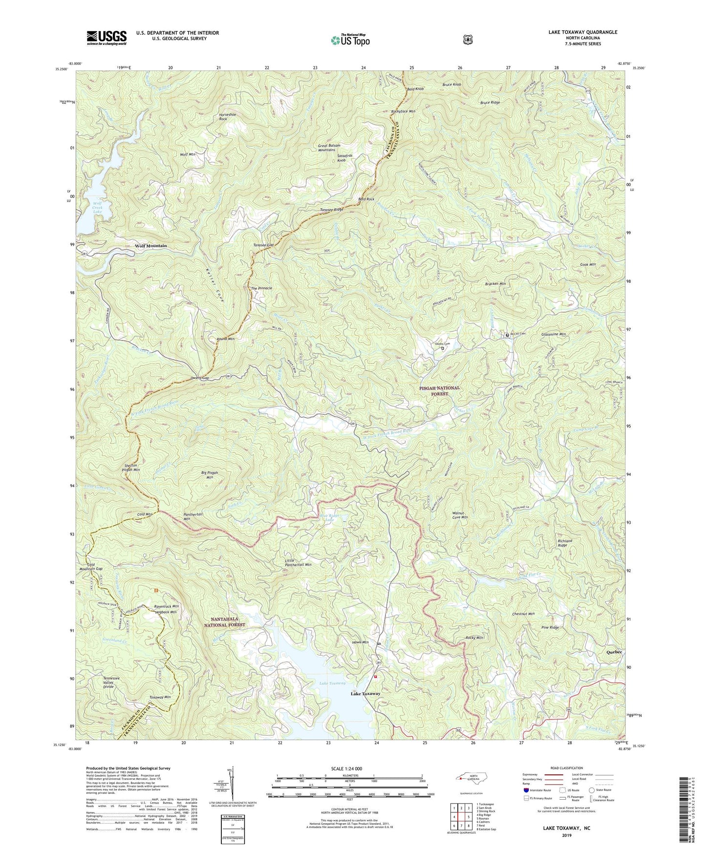
Lake Toxaway North Carolina US Topo Map
Couldn't load pickup availability
Also explore the Lake Toxaway Forest Service Topo of this same quad for updated USFS data
2022 topographic map quadrangle Lake Toxaway in the state of North Carolina. Scale: 1:24000. Based on the newly updated USGS 7.5' US Topo map series, this map is in the following counties: Transylvania, Jackson. The map contains contour data, water features, and other items you are used to seeing on USGS maps, but also has updated roads and other features. This is the next generation of topographic maps. Printed on high-quality waterproof paper with UV fade-resistant inks.
Quads adjacent to this one:
West: Big Ridge
Northwest: Tuckasegee
North: Sam Knob
Northeast: Shining Rock
East: Rosman
South: Reid
Southwest: Cashiers
This map covers the same area as the classic USGS quad with code o35082b8.
Contains the following named places: Bald Knob, Bald Rock, Beasley Creek, Big Pisgah Church, Big Pisgah Mountain, Blue Ridge Hills Lake, Blue Ridge Hills Lake Dam, Blue Ridge Lake, Bracken Creek, Bracken Mountain, Bruce Knob, Bruce Ridge, Camp Cove Branch, Camp Toxaway, Canaan, Charley Creek, Chestnut Mountain, Cold Creek, Cold Mountain, Cold Mountain Gap, Cook Mountain, Deep Ford Creek, Dismal Creek, Dismal Falls, Double Branch, Fork Creek, Fox Ridge, Glassmine Mountain, Hawk Mountain, Hogback Valley, Horseshoe Rock, Indian Lake Estates, Indian Lake Upper, Indian Lake Upper Dam, Jake Branch, Jerry Branch, Johnies Creek, Keller Cove, Lake Toxaway, Lake Toxaway Church, Lake Toxaway Fire Department, Lake Toxaway Post Office, Little Panthertail Mountain, Long Branch, Macedonia Church, McCall Cemetery, McLain Branch, Melhany Creek, Mill Branch, Mill Creek, Miser Creek, North Fork Flat Creek, North Fork Tucker Creek, Oak Grove Church, Owens Cemetery, Owens Gap, Panthertail Mountain, Parker Creek, Pine Ridge, Quebec, Ravenrock Mountain, Richland Creek, Richland Ridge, Rock Bridge, Rocky Mountain, Rockyface Mountain, Round Mountain, Sal Creek, Sassafras Knob, Shelton Pisgah Mountain, South Fork Flat Creek, T Fields Dam, Tanasee Creek, Tanasee Creek Lake, Tanasee Gap, The Pinnacle, Township of Canada, Township of Gloucester, Toxaway Lower Dam, Toxaway Mountain, Toxaway Mountain Lookout, Upper Lake Toxaway, Upper Lake Toxaway Dam, Walnut Cove, Walnut Cove Mountain, Wolf Creek Lake, Wolf Mountain, Wolf Mountain Church, Wolf Ridge, Woods Church, Woods Memorial Church, ZIP Code: 28747