MyTopo
Canal Fulton Ohio US Topo Map
Couldn't load pickup availability
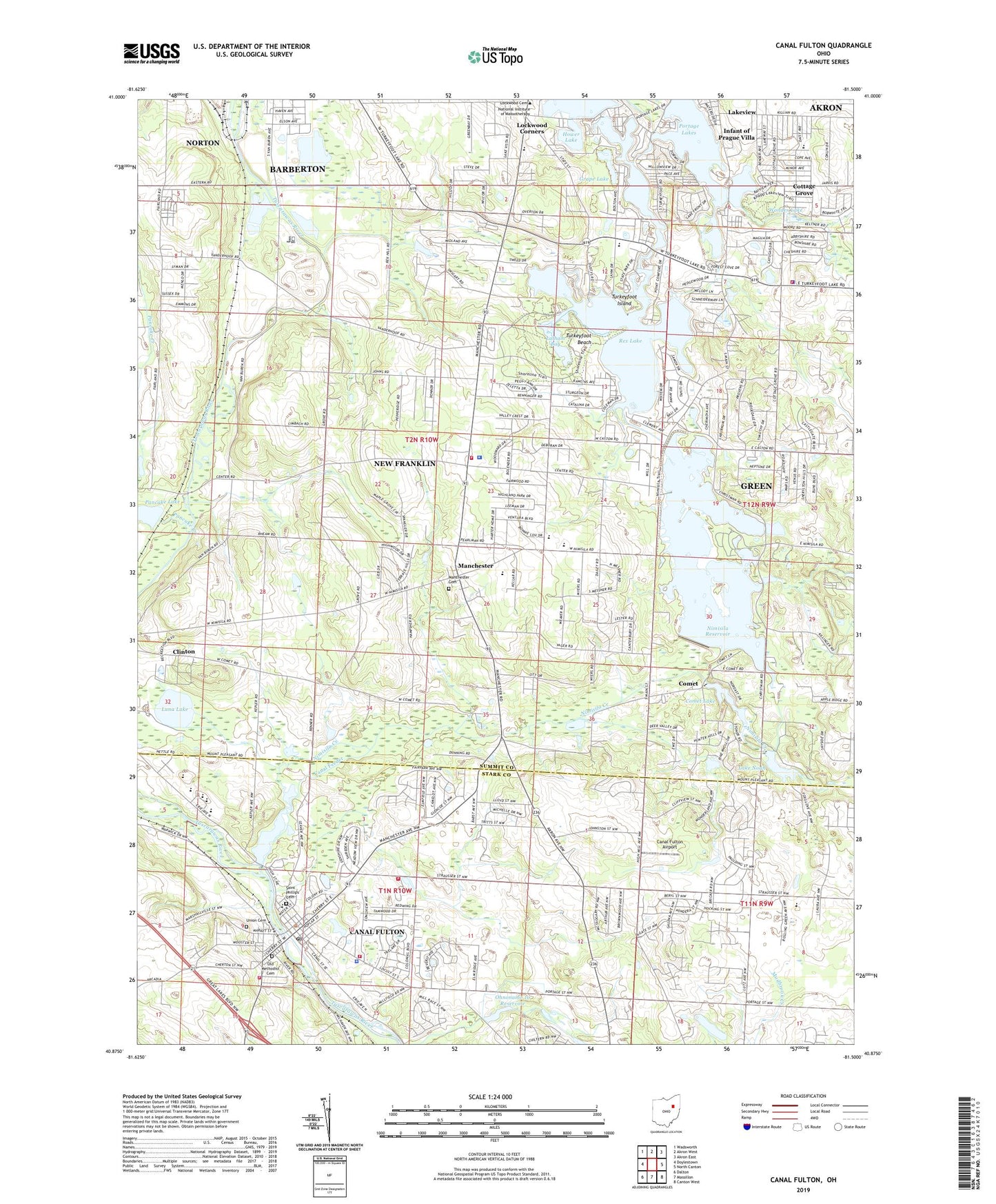
2019 topographic map quadrangle Canal Fulton in the state of Ohio. Scale: 1:24000. Based on the newly updated USGS 7.5' US Topo map series, this map is in the following counties: Summit, Stark. The map contains contour data, water features, and other items you are used to seeing on USGS maps, but also has updated roads and other features. This is the next generation of topographic maps. Printed on high-quality waterproof paper with UV fade-resistant inks.
Quads adjacent to this one:
West: Doylestown
Northwest: Wadsworth
North: Akron West
Northeast: Akron East
East: North Canton
Southeast: Canton West
South: Massillon
Southwest: Dalton
Contains the following named places: Aldawood Hills, Bay Side Picnic Area, Big Oaks Picnic Area, Brimestone Corners, Camelot Hills, Camp Y Noah, Canal Feeder, Canal Fulton, Canal Fulton Airport, Canal Fulton Elementary School, Canal Fulton Fire Department Station 1, Canal Fulton Historic District, Canal Fulton Police Department, Canal Fulton Post Office, Canal Fulton West Side Fire Station, City of Canal Fulton, City of New Franklin, Clardale Farm, Comet, Comet Lake, Comet Lake Dam, Comet Post Office, Comet Trailer Park, Cornerstone Church, Cottage Grove, Cottage Grove Elementary School, Cottage Grove Lake, Country Place Estates, Deer Valley Estates, Ellis Estates, Elson Park, Flight Path Farms, Forestwood, Grape Lake, Green Fire Department - Station 2, Hearthstone Estates, Hemlock Green Estates, Hidden Lake, High Point Picnic Area, Hill Farms, Hillcrest Highlands, Infant of Prague Villa, K and S Greenhouse and Plant Farm, Kings Ridge, Lake Lucern, Lake Lucern Dam, Lake Noah, Lake Noah Dam, Lakeview, Latham Bay, Latham Lane Picnic Area, Lawrence Township Fire Department, Lockwood Corners, Luna Lake, Lyons Den Golf Course, Manchester, Manchester Cemetery, Manchester High School, Manchester Middle School, Merestead Farms, Miller Lake, Mud Lake, New Franklin, New Franklin Fire Department Station 1, New Franklin Fire Department Station 2, New Franklin Police Department, Nimisila Creek, Nimisila Mobile Home Park, Nimisila Reservoir, Nimisila Sunset Heights, Nolley Elementary School, North Reservoir, Northwest High School, Northwest Intermediate School, Ohnoname 10 Dam, Ohnoname 10 Reservoir, Old Methodist Cemetery, Old Park Picnic Area, Pancake Creek, Pancake Lake, Pancake Lake Dam, Pine Knoll Estates, Pleasant Hills Estates, Portage Lakes, Portage Lakes State Park, Portage Lakes Wetland State Nature Preserve, Rex Hill Mobile Home Park, Rex Lake, Robins Trace, Rolling Green Golf Course, Saint Francis de Sales School, Saint Phillips Cemetery, Sandy Beach Trailer Park, Sherylton Hills, Solar Estates, Summit County Sheriff's Office, Tamarack Highlands, Tamarack Lake Estates, Township of Franklin, Turkeyfoot Beach, Turkeyfoot Elementary School, Turkeyfoot Golf Course, Turkeyfoot Heights, Turkeyfoot Island, Turkeyfoot Junction, Turkeyfoot Lake, Union Cemetery, Washington School, West Fulton, West Reservoir, West Reservoir Dam, William S Stinson Elementary School, Withering Heights, Wonder Lake, ZIP Codes: 44216, 44319, 44614