MyTopo
Massillon Ohio US Topo Map
Couldn't load pickup availability
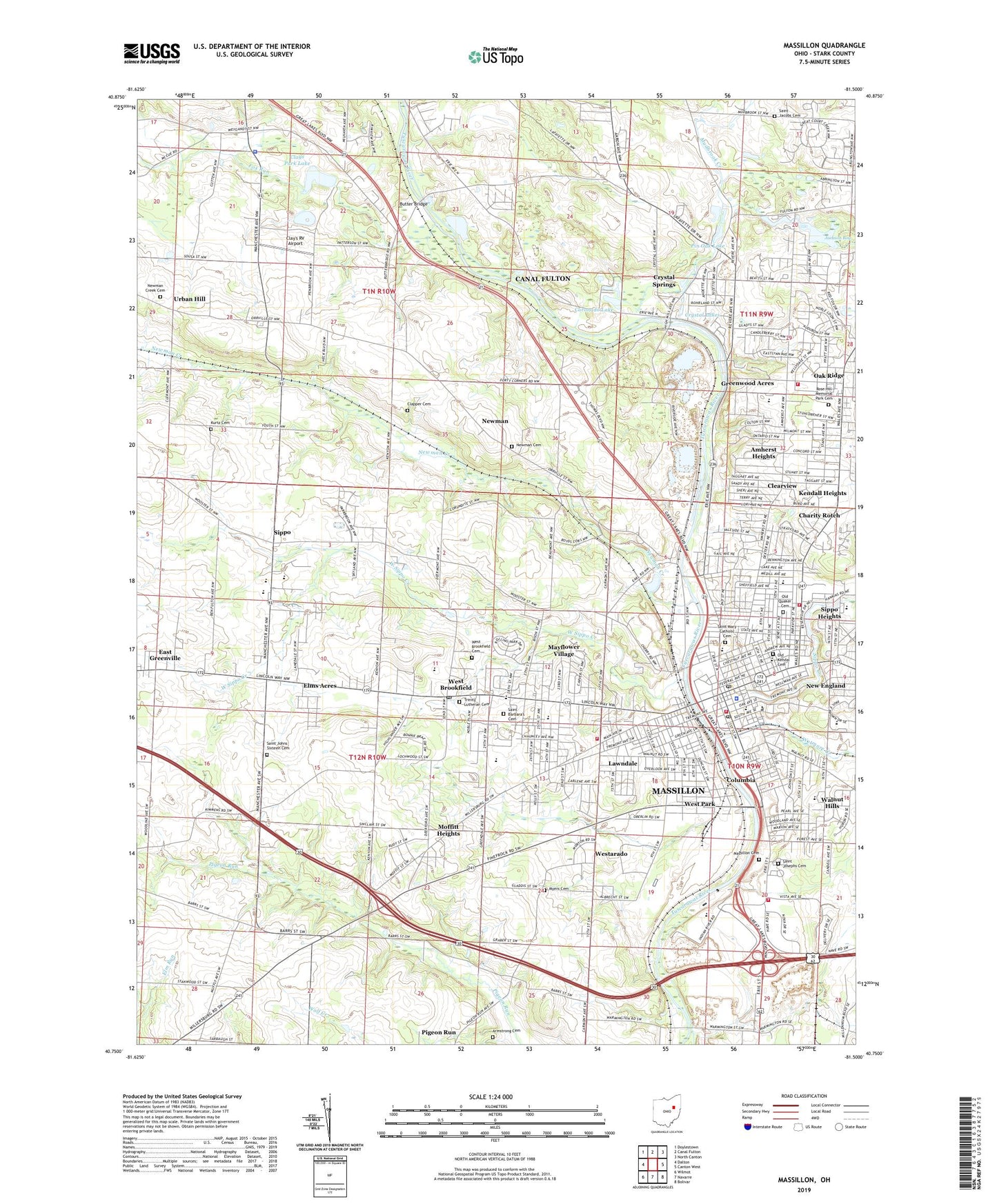
2023 topographic map quadrangle Massillon in the state of Ohio. Scale: 1:24000. Based on the newly updated USGS 7.5' US Topo map series, this map is in the following counties: Stark. The map contains contour data, water features, and other items you are used to seeing on USGS maps, but also has updated roads and other features. This is the next generation of topographic maps. Printed on high-quality waterproof paper with UV fade-resistant inks.
Quads adjacent to this one:
West: Dalton
Northwest: Doylestown
North: Canal Fulton
Northeast: North Canton
East: Canton West
Southeast: Bolivar
South: Navarre
Southwest: Wilmot
This map covers the same area as the classic USGS quad with code o40081g5.
Contains the following named places: Affinity Medical Center - Massillon Campus, Agathon Ball Field, Amherst Elementary School, Amherst Heights, Amherst Park Shopping Center, Andrews Junior High School, Armstrong Cemetery, Arthur Genschaft Memorial Park, Audubon Ridge, Autumn Ridge Estates, Bethel African Methodist Episcopal Church, Bowers Elementary School, Butter Bridge, Calvary Baptist Church of Moffitt Heights, Camp Trinity, Carrington, Central Presbyterian Church, Charity Rotch, Church of Christ, Church of God in Christ, Church of the Nazarene, City of Massillon, Clapper Cemetery, Clays Park, Clays Park Lake, Clays Park Lake Dam, Clay's RV Airport, Clearview, Columbia, Coronado Lake, Coventry Hills, Crystal Lake Park, Crystal Lakes, Crystal Spring Post Office, Crystal Springs, Duncan Plaza Shopping Center, East Brookfield, Edmund A Jones Junior High School, Elms Acres, Elms Country Club, Emerson Elementary School, Epworth Methodist Church, Faith Lutheran Church, Finelrock Industrial Park, First Assembly of God Church, First Baptist Church, First Baptist Church Childrens Center, First Christian Church, First Church of Christ Scientist, First Church of God, First Methodist Church, First Reformed Church, First Spiritualist Church, First United Brethren Church, First Wesleyan Methodist Church, Forty Corners Village, Fourth Street Historic District, Fox Run, Franklin Elementary School, Friendship Baptist Church, Gainey Heliport, Gloucester Village, Gorrell Elementary School, Grace United Church of Christ, Greenwood Acres, Highland Park, Horace Mann Elementary School, Igl Pond, Ilg Pond Dam, Indian River School, Jackson Bog, Jackson Bog State Nature Preserve, Jackson Township Fire Department Station 2, Kendall Heights, Kingdom Hall of Jehovahs Witnesses, Kiwanis Park, Kurtz Cemetery, L And S Trailer Park, Lawndale, Lawrence Township Police Department, Lincoln Elementary School, Lincoln Park, Longfellow Junior High School, Mary Day Sanitarium, Massillon, Massillon Baptist College, Massillon Baptist Temple, Massillon Boys Club, Massillon Cemetery, Massillon City Hall, Massillon Fire Department Central Fire Station, Massillon Fire Department Station 2, Massillon Fire Department Station 3, Massillon Fire Department Station 4, Massillon Industrial Mall, Massillon Municipal Helipad 8, Massillon Municipal Heliport, Massillon Museum, Massillon Police Department, Massillon Post Office, Massillon Public Library, Massillon State Hospital, Massillon Towne Plaza Shopping Center, Massillon Womans Club, Mayflower Village, Midwestern Heliport, Moffitt Heights, Moffitt Heights Elementary School, Mudbrook Creek, Myers Cemetery, Myers Church, Myers School, New England, Newman, Newman Cemetery, Newman Creek, Newman Creek Cemetery, Newman Elementary School, Newman Post Office, North Lawrence Church, North School, North Sippo Park, North Street School, Nova Technology Park, Oak Avenue African Methodist Episcopal Zion Church, Oak Ridge, Ohio Baptist Acres Camp, Ohio Military Museum, Old Kendal Cemetery, Old Quaker Cemetery, Pauls, Pin Oak Lake, Pinn, Reorganized Church of Jesus Christ of Latter Day Saints, Rhodes, Rolling Hills Village, Rose Hill Memorial Park Cemetery, Saint Barbaras Catholic Church, Saint Barbara's Cemetery, Saint Barbaras School, Saint Dymphna Chapel, Saint George Greek Orthodox Church, Saint Jacobs Cemetery, Saint Jacobs Church, Saint James African Methodist Episcopal Church, Saint John Lutheran Church, Saint Johns Sixteen Cemetery, Saint Johns United Church of Christ, Saint Joseph School, Saint Josephs Catholic Church, Saint Josephs Cemetery, Saint Mary Catholic Cemetery, Saint Marys Catholic Church, Saint Marys School, Saint Pauls Church of God in Christ, Saint Pauls Lutheran Church, Saint Timothys Episcopal Church, Salvation Army Citadel, Scenic Ridge, Serenity Shores, Sherwood, Shiloh Baptist Church, Shirver Park, Sippo, Sippo Creek, Sippo Heights, Sippo Post Office, Sixteen Reformed Church, Slankers Mill, Smith Ambulance of Stark - Summit, Smith Elementary School, South Sippo Park, Spring Valley Estates, Thomas W Harvey Elementary School, Top of the Hill Mobile Home Park, Township of Lawrence, Township of Tuscarawas, Trinity Lutheran Cemetery, Trinity Lutheran Church, Tripodi Heliport, Tuslaw High School, Tuslaw Lions Club Park, Twin Maples Sanitarium, Urban Hill, Veterans Park, Wales Square Shopping Center, Walnut Hills, Walnut Hills Christian Church, Walnut Hills Park, Wampler Park, Washington High School, Waterside, Wesley Methodist Church, West Brookfield, West Brookfield Cemetery, West Brookfield Post Office, West Massillon, West Park, West Side Branch Massillon Public Library, West Sippo Creek, Westarado, Wetmore Creek, Whittier School, WTIG-AM (Massillon), ZIP Code: 44647