MyTopo
Chagrin Falls Ohio US Topo Map
Couldn't load pickup availability
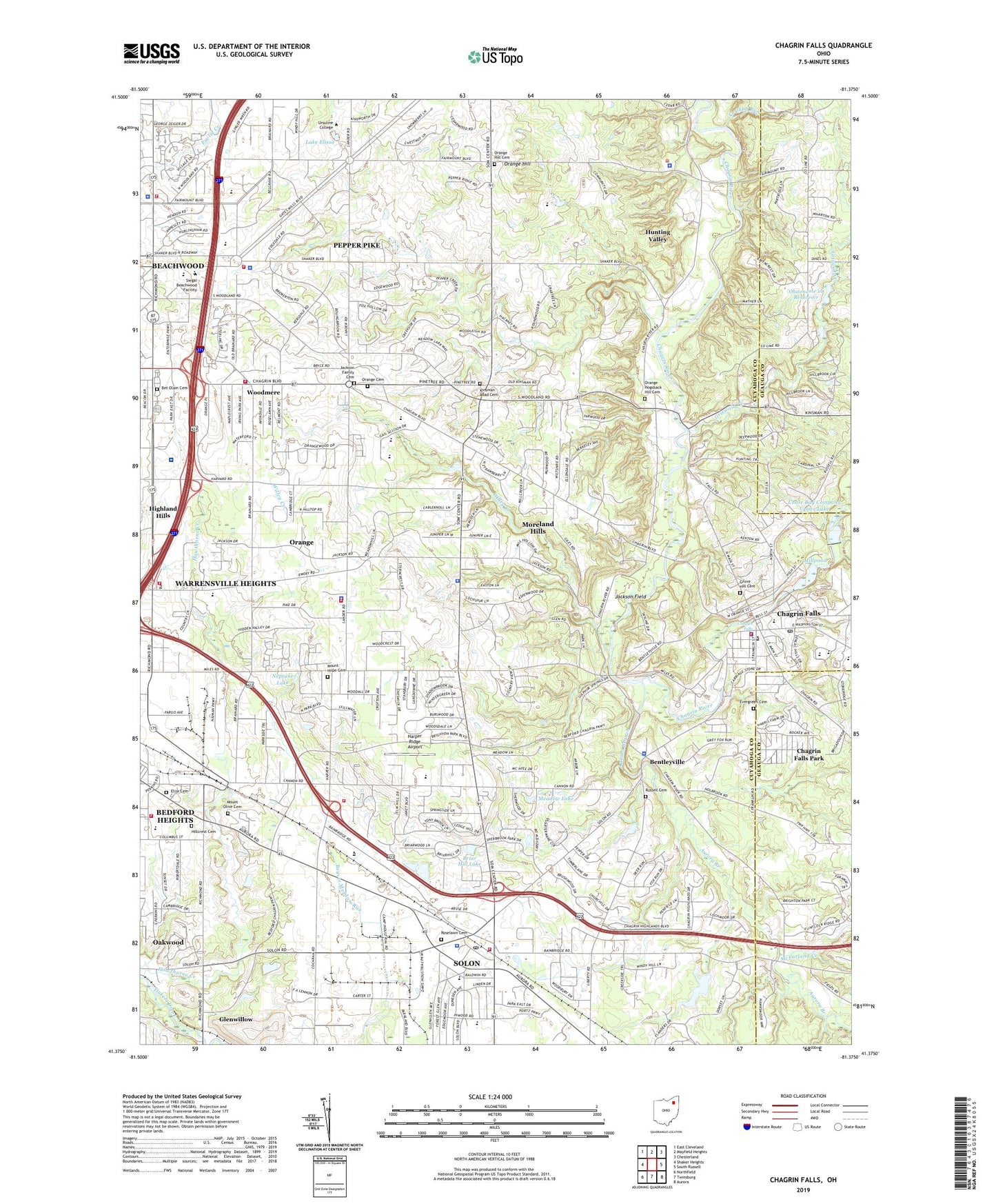
2023 topographic map quadrangle Chagrin Falls in the state of Ohio. Scale: 1:24000. Based on the newly updated USGS 7.5' US Topo map series, this map is in the following counties: Cuyahoga, Geauga. The map contains contour data, water features, and other items you are used to seeing on USGS maps, but also has updated roads and other features. This is the next generation of topographic maps. Printed on high-quality waterproof paper with UV fade-resistant inks.
Quads adjacent to this one:
West: Shaker Heights
Northwest: East Cleveland
North: Mayfield Heights
Northeast: Chesterland
East: South Russell
Southeast: Aurora
South: Twinsburg
Southwest: Northfield
This map covers the same area as the classic USGS quad with code o41081d4.
Contains the following named places: Asbury Seminary, Aurora Branch, Ballard Brady Middle School, Beachwood City Hall, Beachwood Fire Department Station 1 Headquarters, Beachwood Police Department, Bedford Chagrin Parkway, Bedford Heights City Hall, Bedford Heights Fire Department, Bedford Heights Industrial Park, Beechbrook Orphanage, Beechmont Country Club, Beechwood Place Shopping Center, Bentleyville, Bentleyville Police Department, Bet Olam Cemetery, Briar Hill Lake, Century Church, Chagrin Falls, Chagrin Falls Fire Department, Chagrin Falls High School, Chagrin Falls Middle School, Chagrin Falls Park, Chagrin Falls Police Department, Chagrin Falls Post Office, Chagrin Falls Shopping Center, Chagrin Falls Triangle Park Commercial Historic District, Chagrin Falls Wastewater Treatment Facility, Chagrin Falls West Side Historic District, Chagrin State Scenic River, Chagrin Valley Country Club, Chagrin Valley Parkway, Chagrin-Richmond Plaza, Channons Crossing, Chase Bag Company Lower Lake, Chase Bag Company Lower Lake Dam, Chase Bag Company Upper Lake, Chase Bag Company Upper Lake Dam, City of Pepper Pike, City of Solon, Cleveland Clinic Solon Family Health Care Center, Community Church, Congregation Shaarey Tikvah, Cowans, Creek Chub Run, Cuyahoga Regional Sanitary Landfill, Daisy Hill Greenhouses, Dauby Science Center, Dorothy E Lewis Elementary School, Elija Cemetery, Eton Square Shopping Center, Evergreen Cemetery, Evergreen Manor, First Church of Christ Scientist, Fritzsche Center, Fuchs Mizrachi School, Garfield Church, Golf Course Heliport, Grace Hall, Griswold Creek, Grove Hill Cemetery, Harper Ridge Airport, Hawthorn Ridge Picnic Area, Hawthorne Valley Country Club, Heskett Middle School, Hillcrest Cemetery, Hiram House Camp, Hunting Valley, Hunting Valley Police Department, Hunting Valley Village Hall, Ingalls Airport, Jackson Family Cemetery, Jackson Field, Jackson Road Heliport, Joy Plant Heliport, Kinsman Road Cemetery, Lake Elissa, Lander Circle, Landerwood Plaza Shopping Center, Lewis Sands Elementary School, Look About Lodge, Malicki Creek, Matthew O'Brien Campus Center, McFarland Creek, McFarland Homestead, Meadow Lake, Millpond, Moreland Hills, Moreland Hills Country Club, Moreland Hills Police Department, Moreland Hills Primary School, Moreland Hills Village Hall, Mother of Perpetual Help Shrine, Mount Hope Cemetery, Mount Olive Cemetery, Mullen Academic Building, Murphy Hall, Neptune Lake, Nike Site CL-34L, North Solon, Northeast Ohio Medical Reserve Corps, Ohnoname 16 Dam, Ohnoname 16 Reservoir, Orange, Orange Cemetery, Orange Center, Orange High School, Orange Hill, Orange Hill Cemetery, Orange Hogsback Hill Cemetery, Orange Post Office, Orange Town Hall, Orange Village Fire Department, Orange Village Police Department, Orangewood Place Office Building, Pavilion Shopping Center, Pepper Pike, Pepper Pike City Hall, Pepper Pike Country Club, Pepper Pike Elementary School, Pepper Pike Fire Department, Pilla Center, Rabbi Enoch H Kronheim Memorial Library, Ralph M Besse Library, Riverside Park, Roselawn Cemetery, Russell Cemetery, Saint Jude Catholic Church, Saint Judes School, Saint Lukes Emergency Center, Saint Mark Center, Saint Martins Church, Siegal Beachwood Facility, Sister Dorothy Kazel Global Awareness Center, Solar Shopping Center, Solon, Solon City Hall, Solon Community Park, Solon Fire Department Station 1, Solon Fire Department Station 2, Solon High School, Solon Mall Shopping Center, Solon Police Department, Solon Post Office, Solon Square Shopping Center, Som Jackson Heliport, Sophia Center, South Chagrin Reservation, Squaw Rock Picnic Area, Stepnorth Retail Cluster Mall Shopping Center, Sulphur Springs Picnic Area, Temple Brith Emeth, The Shelterhouse Picnic Area, Township of Chagrin Falls, Trinity Church, United Methodist Church of Chagrin Falls, University Hospitals Ahuja Medical Center, University Mednet Clinic, Ursuline College, Ursuline Educational Center, V J S Heliport, Village of Bentleyville, Village of Chagrin Falls, Village of Hunting Valley, Village of Moreland Hills, Village of Orange, Village of Woodmere, Village Square Shopping Center, Warrensville Heights Fire Department Station 2, Wasmer Gallery, WCLV-FM (Cleveland), Willey Creek, Windsor Hospital, WJMO-FM (Cleveland Heights), Woodmere, Woodmere Fire Department, Woodmere Village Police Department, ZIP Codes: 44022, 44139