MyTopo
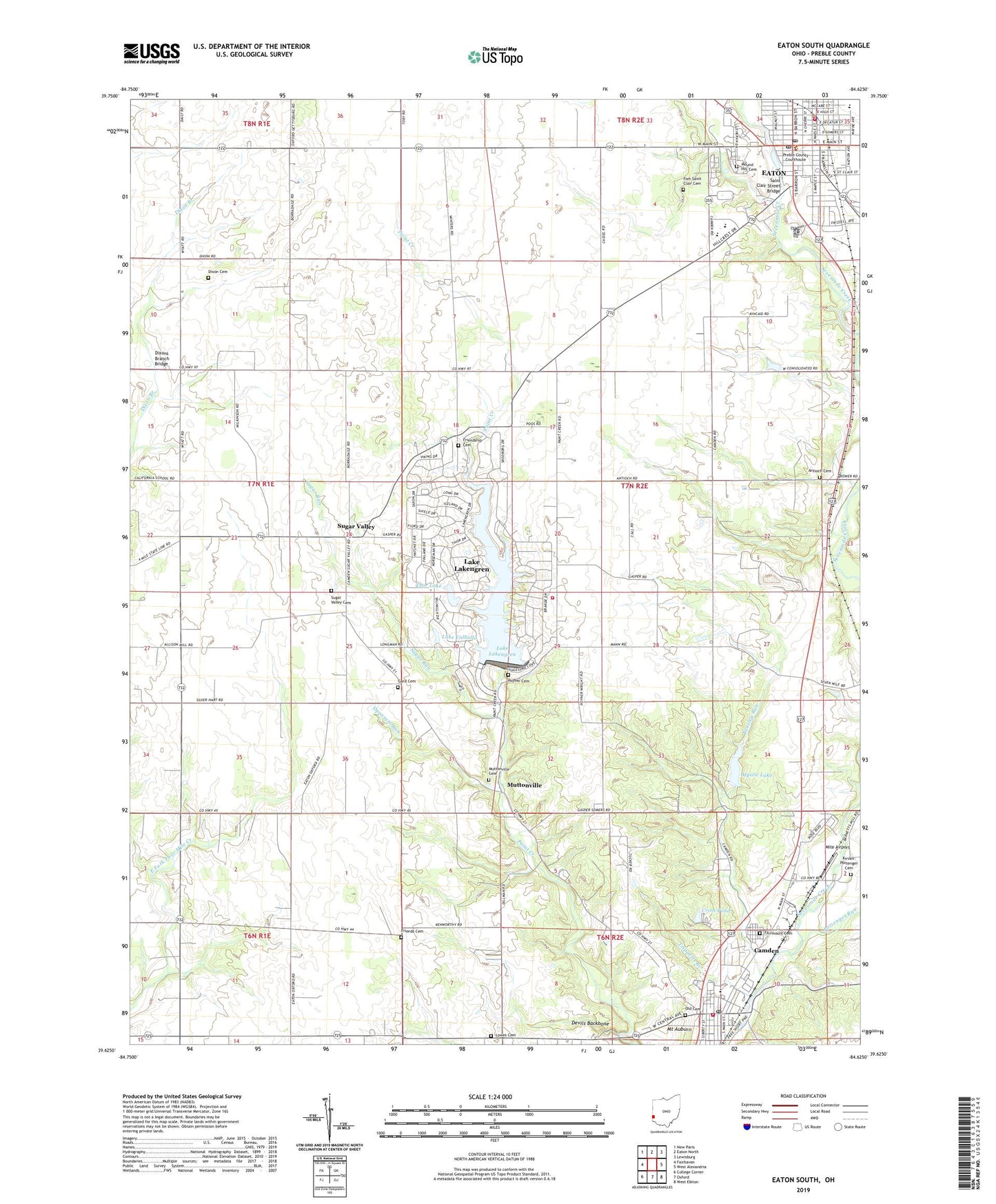
Eaton South Ohio US Topo Map
Couldn't load pickup availability
2019 topographic map quadrangle Eaton South in the state of Ohio. Scale: 1:24000. Based on the newly updated USGS 7.5' US Topo map series, this map is in the following counties: Preble. The map contains contour data, water features, and other items you are used to seeing on USGS maps, but also has updated roads and other features. This is the next generation of topographic maps. Printed on high-quality waterproof paper with UV fade-resistant inks.
Quads adjacent to this one:
West: Fairhaven
Northwest: New Paris
North: Eaton North
Northeast: Lewisburg
East: West Alexandria
Southeast: West Elkton
South: Oxford
Southwest: College Corner
Contains the following named places: Antioch Cemetery, Antioch Church, Antioch Springs Farm, Barnet School, Beasley Run, Brooke-Gould Memorial Library, Brubaker Farms, Bruce Elementary School, Camden, Camden - Somers Township Fire and Rescue, Camden Elementary School, Camden High School, Camden Pentecostal Church, Camden Post Office, Camden United Methodist Church, Camp Cartwright, Church of Christ, Conarroe Corners, Corvin, Cross Pond, Cross Pond Dam, Dearth Building, Devils Backbone, Dixon Cemetery, Dixons Branch Bridge, Eaton, Eaton Church of Christ, Eaton Country Club, Eaton Fire and EMS Division Station 1, Eaton High School, Eaton Police Division, Eaton Post Office, Eaton United Church of Christ, Evangel Assembly of God Church, Fairmount Cemetery, First Church of God, First Southern Baptist Church, First United Presbyterian Church, Flora School, Fort Saint Clair Cemetery, Fort Saint Clair State Park, Fosterville, Friends Cemetery, Friendship Cemetery, Friendship Church, Gard Cemetery, Gasper Township Fire Department, Grace Brethren Church, Grace Lutheran Church, Hart School, Hollingsworth East Elementary School, Kirven - Pottenger Cemetery, Lake Lakengren, Lake Lakengren Census Designated Place, Lake Lakengren Dam, Lake Valhalla, Lake Valhalla Dam, Lohrey Farms, Lowers School, Lowes Cemetery, Mite Airport, Mound Hill Cemetery, Mount Auburn, Muttonville, Muttonville Cemetery, Mystic Lake, Mystic Lake Dam, Old Cemetery, Opossum Run, Pioneer School, Pottenger Run, Poyner Cemetery, Preble County, Preble County Courthouse, Preble County Sanitary Landfill, Quail Trail, Quaker Ridge School, Ramsey School, Right Place Farm, Saint Clair Springs Childrens Home, Saint Clair Street Bridge, Saint Mary Church, Saint Paul United Methodist Church, Sugar Run, Sugar Valley, Sugar Valley Cemetery, Sugar Valley Farm, Sugar Valley Post Office, Sugar Valley United Methodist Church, Thor Lake, Thor Lake Dam, Township of Gasper, Trippetts Branch, Village of Camden, Visitation Catholic Church, Walters School, Weadick Farm, Windy Hill Farms, Woodland Trails, ZIP Code: 45311