MyTopo
New Albany Ohio US Topo Map
Couldn't load pickup availability
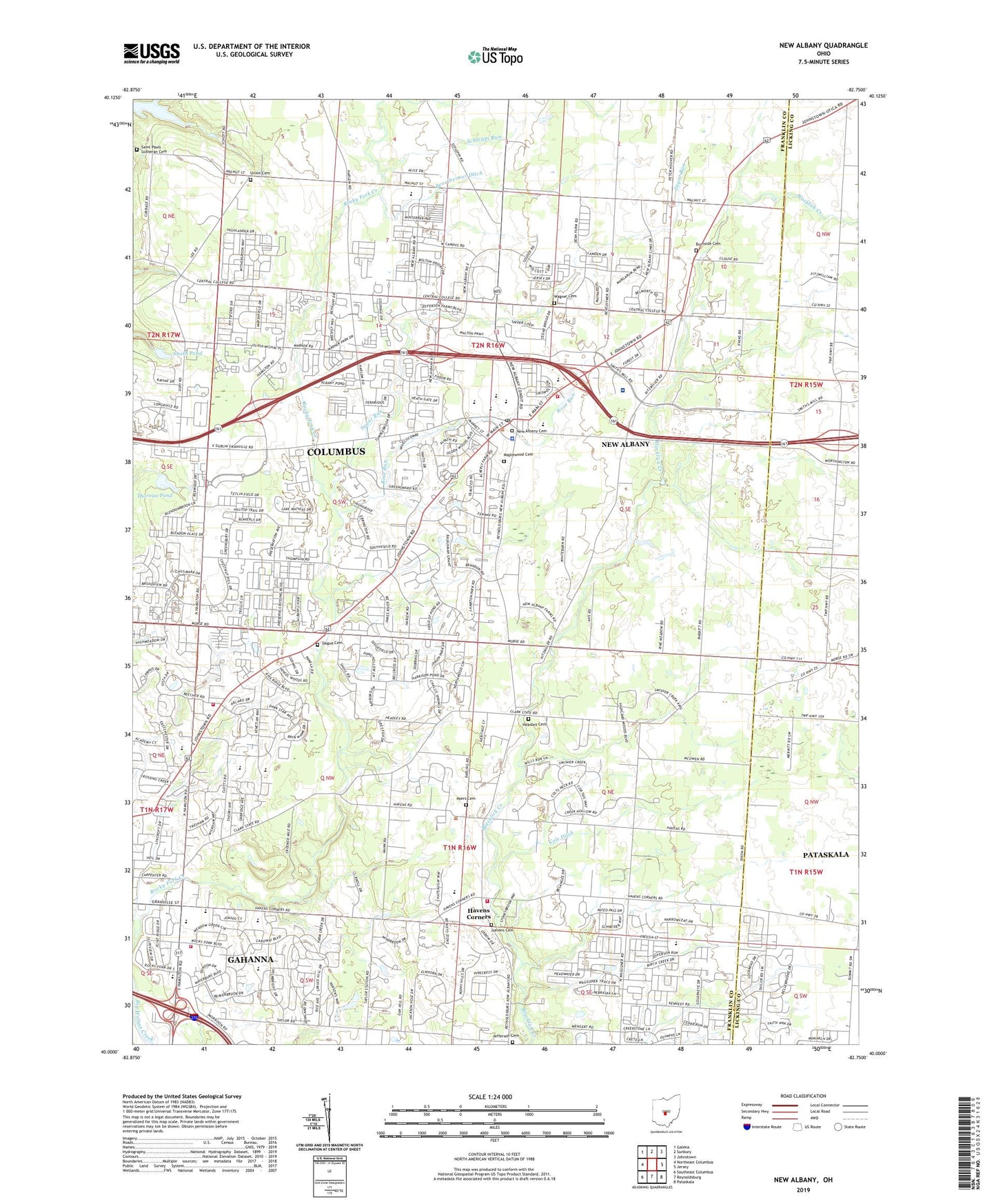
2023 topographic map quadrangle New Albany in the state of Ohio. Scale: 1:24000. Based on the newly updated USGS 7.5' US Topo map series, this map is in the following counties: Franklin, Licking. The map contains contour data, water features, and other items you are used to seeing on USGS maps, but also has updated roads and other features. This is the next generation of topographic maps. Printed on high-quality waterproof paper with UV fade-resistant inks.
Quads adjacent to this one:
West: Northeast Columbus
Northwest: Galena
North: Sunbury
Northeast: Johnstown
East: Jersey
Southeast: Pataskala
South: Reynoldsburg
Southwest: Southeast Columbus
This map covers the same area as the classic USGS quad with code o40082a7.
Contains the following named places: Ackerly Park, Albany Park, Asbury Heights, Ayers Cemetery, Beech, Beech Post Office, Beth Messiah Congregation, Bevelheimer Ditch, Bevelheimer Park, Burnside Cemetery, Cedar Run, City of New Albany, Clivdon, Clivdon Mews, Cobblestone At The Preserve, Cole Ditch, Colts Neck, Creekstone, Dague Cemetery, Ealy Crossing, Estates At Fieldstone, Fenway, Fieldstone, First Korean Church of Columbus, Franklin Church, Gahanna City Hall, Gahanna Municipal Heliport, Gahanna Post Office, Gahanna Woods Park, Hampstead Green, Hampstead Heath, Hamptons At New Albany, Havens Cemetery, Havens Corners, Havens Corners Church of Christ in Christian Union, Havens Corners Post Office, Havenswood, Headley Cemetery, Hoover Reservoir, Hunters Ridge Mall Shopping Center, Jefferson Cemetery, Jefferson Community Park, Jefferson Estates, Jefferson Meadows, Jefferson Township Administration Building, Jefferson Township Fire Department, Jersey Chapel, Kerr-Harrington House Museum, Kitzmiller Crossing, Lambton Park, Lansdowne, Lincoln Elementary School, Lincoln High School, Lincoln Schools, Lyttle Airport, Maplewood Cemetery, Mifflin Township Division of Fire Station 131 Headquarters, Mifflin Township Fire Station 133, Morrison Farms, Mount Carmel New Albany Surgical Hospital, New Albany, New Albany Cemetery, New Albany Country Club, New Albany Elementary School, New Albany Farms, New Albany High School, New Albany Middle School, New Albany Police Department, New Albany Post Office, New Albany Village Hall, Oakland, Ovid, Ovid Post Office, Parkwood, Pickett Place, Pinecrest, Plain Township Fire Department, Plain Township Park, Planters Grove, Rocky Point Plaza Shopping Center, Rogers Corner Shopping Center, Rose Run, Rose Run Park, Royal Elm, Saint Matthews School, Saint Pauls Church, Saint Pauls Lutheran Cemetery, Schleppi Run, Shepherd Church of The Nazarene, Smith Pond, Smith Pond Dam, Stepping Stone, Stone Ridge Plaza Shopping Center, Sugar Run, Swickard Woods, Taylor Station Church, The Golf Club, The Greens At Clarenton, The Offices at North High Place, The Woods At Havens Run, Thoreau Pond, Thoreau Pond Dam, Township of Blendon, Township of Jefferson, Township of Mifflin, Township of Plain, Union Cemetery, United Baptist Church, Villas At Hawks Crest, Vista Plaza Shopping Center, Waggoner Chase, Waggoner Trace, Wagner Cemetery, Walden Waterfowl Refuge, Waterston, WCVO-FM (Gahanna), Willow Brook Crossing, Winding Hollow Country Club, Wiveliscombe, Wonderland, Wonderland Community Church, Wonderland Post Office, Woods At Sugar Run, ZIP Codes: 43004, 43054, 43230