MyTopo
Peninsula Ohio US Topo Map
Couldn't load pickup availability
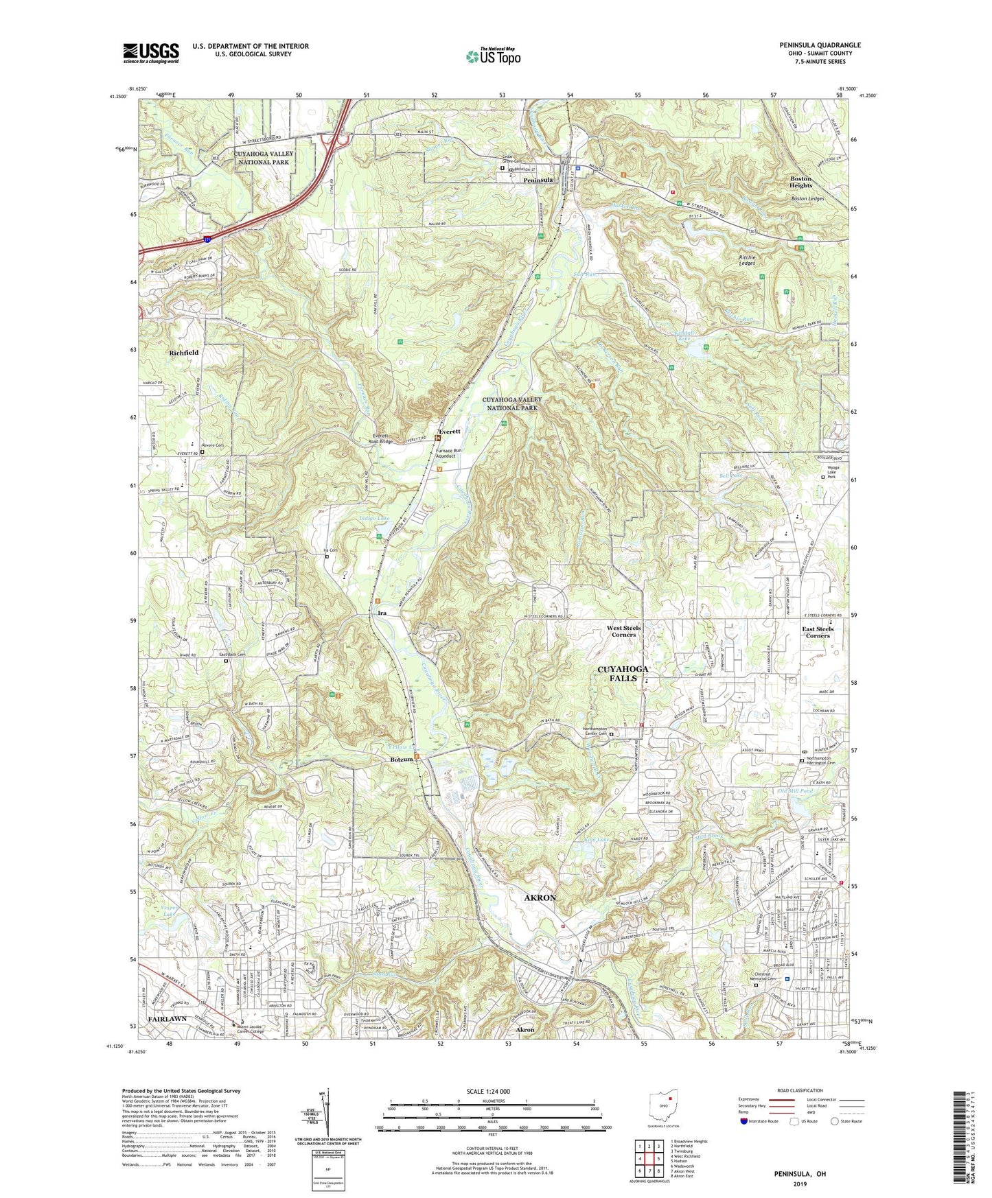
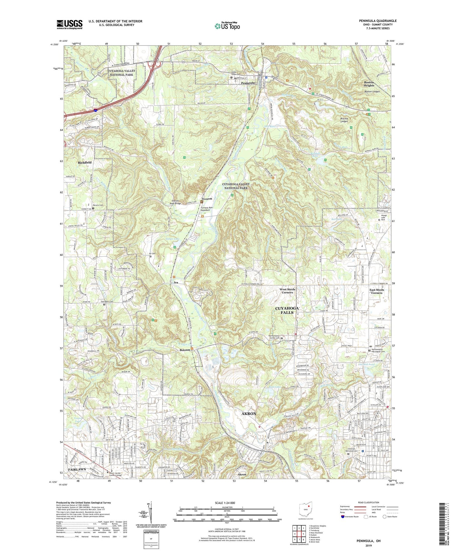
2019 topographic map quadrangle Peninsula in the state of Ohio. Scale: 1:24000. Based on the newly updated USGS 7.5' US Topo map series, this map is in the following counties: Summit. The map contains contour data, water features, and other items you are used to seeing on USGS maps, but also has updated roads and other features. This is the next generation of topographic maps. Printed on high-quality waterproof paper with UV fade-resistant inks.
Quads adjacent to this one:
West: West Richfield
Northwest: Broadview Heights
North: Northfield
Northeast: Twinsburg
East: Hudson
Southeast: Akron East
South: Akron West
Southwest: Wadsworth
Contains the following named places: Akron Fire Department Station 11, Akron Regional Landfill, Akron Water Pollution Control Station, Alder Creek Centre Shopping Center, Ascot Park, Babb Run Park, Bell Lake, Bell Lake Dam, Billow Memorial Chapel, Blossom Music Center, Bolich Middle School, Boston Ledges, Boston Run, Botzum, Botzum Post Office, Brandywine Golf Club, Camp Butler Lake, Camp Butler Lake Dam, Camp Christopher, Camp Manatoc, Camp Mueller, Cedar Grove Cemetery, Chestnut Hill Memorial Cemetery, City of Fairlawn, Cranmer, Cranmer Post Office, Croghan Park, Cuyahoga Falls Fire Department Station 3, Cuyahoga Falls Fire Department Station 4, Deep Lock, Dickerson Run, East Bath Cemetery, East Steels Corners, Everett, Everett Post Office, Everett Road Bridge, Fair Lawn Lutheran Church, Fairlawn, Fairlawn Plaza Shopping Center, Fairlawn Post Office, Furnace Run, Furnace Run Aqueduct, Furnace Run South, Greater State Road Shopping Center, Hale Run, Harrington Cemetery, Haskell Run, Herberich Primary School, Hillcrest Elementary School, Immaculate Heart of Mary Church, Immaculate Heart of Mary School, Indian Rock Centre Shopping Center, Indian Springs Mobile Home Park, Indigo Lake, Indigo Lake Station, Indigo Lake Trailhead, Ira, Ira Cemetery, Ira Creek, Ira Post Office, Iron Bridge, Joeys Run, Kendall Lake, Kool Lake, Lake Litchfield, Lake Litchfield Dam, Langes Run, Ledgewood Camp, Liberty Commons Shopping Center, McDowell Branch Akron-Summit County Public Library, Merchants Square Shopping Center, Merriman Centre Shopping Center, Merriman Valley Shopping Center, Mother of Sorrows Church, Mud Brook, Newberry Park, North Revere Run, North Revere Run East, Northampton Baptist Church, Northampton Center, Northampton Center Cemetery, Northampton School, Northampton Square Shopping Center, Northampton United Methodist Church, Northlawn Memorial Gardens, Northminster Presbyterian Church, Oak Leaf Mobile Home Park, Old Mill Pond, Old Portage Heliport, Pancake Lock, Parkwood Plaza Shopping Center, Peninsula, Peninsula Post Office, Peninsula United Methodist Church, Peninsula Village Historic District, Revere Cemetery, Revere High School, Revere Middle School, Revere Run, Richardson Elementary School, Richfield Coliseum, Riding Run, Ritchie Ledges, Ritchie Run, Robinson Run, Saalfield Pond Dam Number One, Saalfield Pond Number One, Salt Run, Sand Run, Sand Run Metropolitan Park, Slipper Run, Sourek Run, State Road Mall Shopping Center, State Road Post Office, Steeles Corners Christian Church, Summit County, Summit Mall Shopping Center, Tamsin Park, Township of Boston, Township of Northampton, Unitarian Universalist Church of Akron, Valley Fire District Station 1, Valley View Golf Club, Valley Vista Park, Vesper Lake, Village of Peninsula, Village of Peninsula Police Department, Virginia Kendall Park, Virginia Kendall Park Lake Dam, Waupaca Run, WCUE-AM (Cuyahoga Falls), West Steels Corners, Western Reserve Hospital, WKDD-FM (Akron), Wood Park, Woodridge High School, Woodridge Intermediate Elementary School, Woodward Creek, WSLR-AM (Akron), Yellow Creek, ZIP Codes: 44223, 44264, 44313