MyTopo
Wauseon Ohio US Topo Map
Couldn't load pickup availability
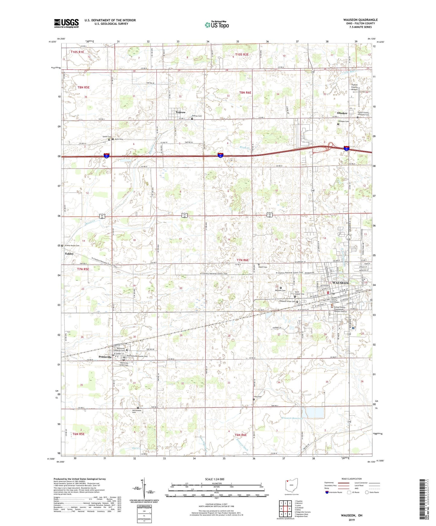
2023 topographic map quadrangle Wauseon in the state of Ohio. Scale: 1:24000. Based on the newly updated USGS 7.5' US Topo map series, this map is in the following counties: Fulton. The map contains contour data, water features, and other items you are used to seeing on USGS maps, but also has updated roads and other features. This is the next generation of topographic maps. Printed on high-quality waterproof paper with UV fade-resistant inks.
Quads adjacent to this one:
West: Archbold
Northwest: Fayette
North: Morenci
Northeast: Lyons
East: Delta
Southeast: Napoleon East
South: Napoleon West
Southwest: Ridgeville Corners
This map covers the same area as the classic USGS quad with code o41084e2.
Contains the following named places: Aeschliman Cemetery, Ayers Cemetery, Bayes Cemetery, Bethel Church, Burr Road Middle School, Christ United Methodist Church, Church of the Master United Methodist Church, City of Wauseon, Congregational United Church of Christ, Depot Park, Dover Glen, Eckley, Eckley Amish Cemetery, Elm Street Elementary School, Emmaus Evangelical Lutheran Church, Evangelical Mennonite Church, Exit 3 Airport, First Baptist Church, First Christian Church, First Church of God, Fountain Church, Fulton County, Fulton County Administration Building, Fulton County Airport, Fulton County Courthouse, Fulton County Economic Opportunity Center, Fulton County Emergency Medical Services, Fulton County Fairgrounds, Fulton County Health Center, Fulton County Historical Museum, Fulton County Infirmary Cemetery, Fulton County Sheriff's Office, Homecoming Park, Ironwood Golf Course, Lena Cemetery, Memorial Auditorium, Mikesell Cemetery, North Clinton Mennonite Church, North Park, Ottokee, Ottokee Cemetery, Ottokee Post Office, Ottokee Station, Pettisville, Pettisville Cemetery, Pettisville Census Designated Place, Pettisville Elementary School, Pettisville High School, Pettisville Lutheran Cemetery, Pettisville Missionary Church, Pettisville Post Office, Pettisville Union Cemetery, Reighard Park, Rotary Park, Saint Caspar Cemetery, Saint Caspers Roman Catholic Church, School Number 1, School Number 11, School Number 14, School Number 3, School Number 4, School Number 5, School Number 6, School Number 7, School Number 8, School Number 9, Smith Cemetery, South Park, Star Mobile Court, Tedrow, Tedrow Assembly of God Church, Tedrow Cemetery, Tedrow Census Designated Place, Tedrow Mennonite Church, Tedrow Post Office, Tedrow United Methodist Church, The Church of Jesus Christ of Latter Day Saints, Timber Creek, Township of Clinton, Township of Dover, Trinity Lutheran Church, Wabash Park, Wauseon, Wauseon Church of the Nazarene, Wauseon Depot, Wauseon Elementary School, Wauseon Fire Department, Wauseon High School, Wauseon Middle School, Wauseon Police Department, Wauseon Post Office, Wauseon Public Library, Wauseon Reservoir, Wauseon Reservoir Number Two, Wauseon Town Hall, Wauseon Union Cemetery, Wauseon Water Treatment Plant, West Clinton Mennonite Church, West Fulton Dunkard Brethren Church, WMTR-FM (Archbold), ZIP Codes: 43553, 43567