MyTopo
Edmond Oklahoma US Topo Map
Couldn't load pickup availability
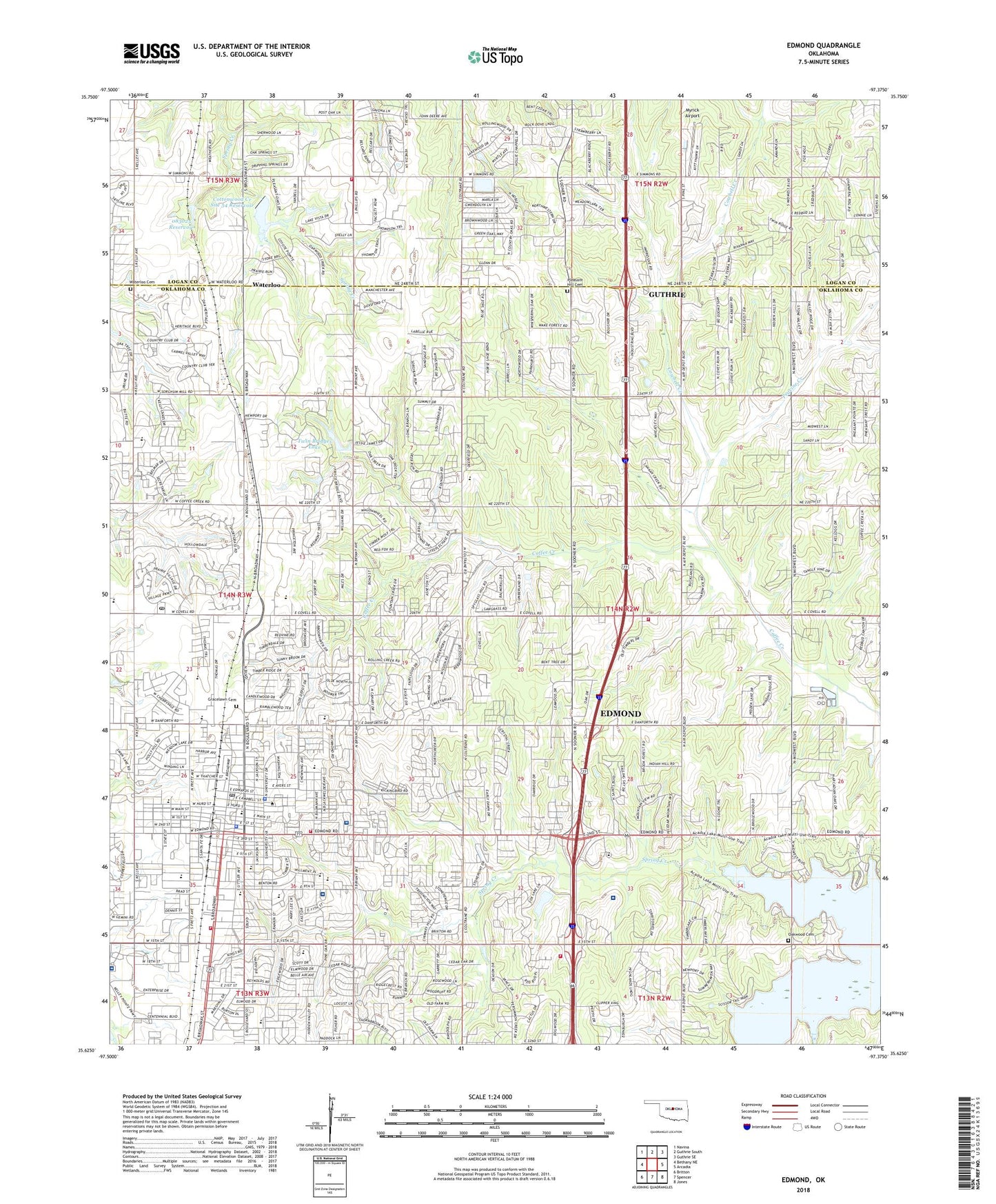
2018 topographic map quadrangle Edmond in the state of Oklahoma. Scale: 1:24000. Based on the newly updated USGS 7.5' US Topo map series, this map is in the following counties: Oklahoma, Logan. The map contains contour data, water features, and other items you are used to seeing on USGS maps, but also has updated roads and other features. This is the next generation of topographic maps. Printed on high-quality waterproof paper with UV fade-resistant inks.
Quads adjacent to this one:
West: Bethany NE
Northwest: Navina
North: Guthrie South
Northeast: Guthrie SE
East: Arcadia
Southeast: Jones
South: Spencer
Southwest: Britton
Contains the following named places: AMG Specialty Hospital - Edmond, Baptist Student Union-Edmond, Belmont Farms, Bryant Square, Caisteal Creek, Calvary Temple, Cathedral of the Hills, Centennial Elementary School, Central Middle School, Channing Unitarian-Universalist, Cheyenne Middle School, Chitwood Park, Christian Faith, Church of Christ-Midway, Church of Christ-Westwood, Church of God, City of Edmond, Clegern Elementary School, Coffee Creek Post Office, Cottonwood Creek Site 54 Dam, Cottonwood Creek Site 54 Reservoir, Cowbell Creek, Cross Timbers Elementary School, Edmond, Edmond Airport, Edmond Christian Church, Edmond Church of Christ, Edmond Family Worship Center, Edmond Fire Department Station 1, Edmond Fire Department Station 2, Edmond Fire Department Station 4, Edmond Fire Department Station 5, Edmond North High School, Edmond Plaza, Edmond Police Department, Edmond Post Office, Emmanuel Southern Baptist Church, Fairview Church, Faith Bible Church, Faith Family Worship Center, Fink Park, First Christian Church-Edmond, First Church of the Nazarene, First United Methodist Church, Gracelawn Cemetery, Hafer Park, Henderson Hills Baptist Church, Heritage Baptist Church, Highland Park Baptist Church, Howell School, Ida Freeman Elementary School, John Ross Elementary School, KCSC-FM (Edmond), KOKF-FM (Edmond), Memorial High School, Myrick Airport, New Covenant United Methodist Church, North Oaks Shopping Center, North Waterloo Gas and Oil Field, Northeast Edmond Gas and Oil Field, Northern Hills Elementary School, Oak Cliff Fire Protection District Station 1, Oaktree Assembly of God, Oakwood Cemetery, Oklahoma Christian Academy, Oklahoma Christian Health, Oklahoma Christian School, Oklahoma University Medical Center Edmond, Oknoname 083025 Dam, Oknoname 083025 Reservoir, Orvis Risner Elementary School, Peace Lutheran Church, Peavine Creek, Philadelphia Church of God, Pleasant Hill Cemetery, Reorganized Church of Jesus, Russell Dougherty Elementary School, Saint Elizabeth Ann Seton School, Saint Johns Catholic Church, Saint Mark Lutheran Church, Saint Marys Episcopal Church, Saint Mary's Episcopal School, Saint Marys School, Sequoyah Middle School, Summit Medical Center, Sunset Elementary School, Sunset Heights Baptist Church, Township of Edmond, Trinity Community Center, Twin Bridges Dam, Twin Bridges Lake, United Baptist Church, University of Central Oklahoma, University of Central Oklahoma Campus Police Department, Waterloo, Waterloo Cemetery, Waterloo Road Baptist Church, Wesley Foundation Ministries, Westbrook Shopping Center, Will Rogers Elementary School, ZIP Codes: 73003, 73034